| Title | Date | Type | Setname | ||
|---|---|---|---|---|---|
| 51 |
 |
Governor's Conference (1937) P.1 | 1937-09-16 | Image/StillImage | dha_cp |
| 52 |
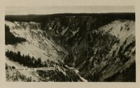 |
Grand Canyon of the Yellowstone River, within the national park | 1920; 1921; 1922; 1923; 1924; 1925; 1926; 1927; 1928; 1929 | Image/StillImage | uum_map |
| 53 |
 |
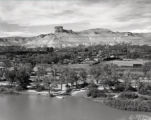
Grand Teton p.1 | 1924 | Image/StillImage | dha_cp |
| 54 |
 |
Great falls of the Yellowstone, from point lookout | 1920; 1921; 1922; 1923; 1924; 1925; 1926; 1927; 1928; 1929 | Image/StillImage | uum_map |
| 55 |
 |
Green River p.1 | 1933-07-24 | Image/StillImage | dha_cp |
| 56 |
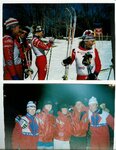 |
Heidi Selnes and the University of Utah Ski Team [02] | 1996-03-06; 1996-03-07; 1996-03-08; 1996-03-09 | Image/StillImage | uum_map_usa |
| 57 |
 |
Horse Creek (Wyo.) p. 1 | 1925; 1926; 1927; 1928; 1929; 1930; 1931; 1932; 1933; 1934; 1935; 1936; 1937; 1938 | Image/StillImage | dha_cp |
| 58 |
 |
Howard home at Byron | 1907; 1908; 1909; 1910; 1911; 1912; 1913; 1914; 1915; 1916; 1917; 1918; 1919; 1920; 1921; 1922; 1923; 1924; 1925; 1926; 1927; 1928; 1929; 1930; 1931; 1932; 1933; 1934; 1935 | Image/StillImage | uum_map |
| 59 |
 |
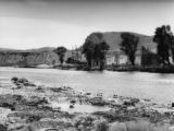
Independence Rock, the Sweetwater River and Devil's Gate | 1930; 1931; 1932; 1933; 1934; 1935; 1936; 1937; 1938; 1939; 1940; 1941; 1942; 1943; 1944; 1945; 1946; 1947; 1948; 1949; 1950; 1951; 1952; 1953; 1954; 1955; 1956; 1957; 1958; 1959; 1960 | Image/StillImage | uum_map |
| 60 |
 |
Indian Sketches from the Journals of T. D. Brown and Jacob Hamblin | 1869 | Image/StillImage | uaida_main |
| 61 |
 |
Inscription Island | 1940; 1941; 1942; 1943; 1944; 1945; 1946; 1947; 1948; 1949; 1950 | Image/StillImage | dha_alwmc |
| 62 |
 |
Kings Peak, Utah-Wyoming 1982 | 1982 | Image/StillImage | ucl_maps |
| 63 |
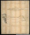 |
Map of an exploring expedition to the Rocky Mountains in the year 1842 and to Oregon & North California in the years 1843-44 | 1845 | Image/StillImage | uu_awm |
| 64 |
 |
Map of Indian Reservation in the West, 1929 | Image/StillImage | uaida_main | |
| 65 |
 |
Map of Northern Utah, Early Settlements | Image/StillImage | uaida_main | |
| 66 |
 |
Map of Shoshone, Goshute, Bannock, Wind River and Panamint Indian Tribal Groups | 1957 | Image/StillImage | uaida_main |
| 67 |
 |
Map of Western Indian Territory Before 1850 | Image/StillImage | uaida_main | |
| 68 |
 |
Map showing the boundary of the Shoshone Indian territory | 1941 | Image/StillImage | uaida_main |
| 69 |
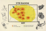 |
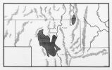
Map titled "Ute Bands Map" | Image/StillImage | uaida_main | |
| 70 |
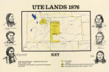 |
Map titled "Ute Lands, 1876" | Image/StillImage | uaida_main | |
| 71 |
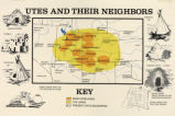 |
Map titled, "Utes and Their Neighbors" | Image/StillImage | uaida_main | |
| 72 |
 |
Marriner Eccles and friends [02] | 1930; 1931; 1932; 1933; 1934; 1935; 1936; 1937; 1938; 1939; 1940; 1941; 1942; 1943; 1944; 1945; 1946; 1947; 1948; 1949; 1950; 1951; 1952; 1953; 1954; 1955; 1956; 1957; 1958; 1959; 1960 | Image/StillImage | uum_map |
| 73 |
 |
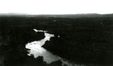
Meandering Stream - Yellowstone NP | 1910; 1911; 1912; 1913; 1914; 1915; 1916; 1917; 1918; 1919; 1920; 1921; 1922; 1923; 1924; 1925; 1926; 1927; 1928; 1929; 1930; 1931; 1932; 1933; 1934; 1935 | Image/StillImage | uum_map |
| 74 |
 |
Mormon Pioneer Trail | Image/StillImage | ucl_maps | |
| 75 |
 |
Mountain range, possibly Glacier National Park | 1930; 1931; 1932; 1933; 1934; 1935; 1936; 1937; 1938; 1939; 1940 | Image/StillImage | uum_map |