Home
Browse
Ask Us
Chat
Harmful Language Statement
Log in
Advanced Search
Year
1845
1846
1847
1848
1849
1850
1851
1852
1853
1854
1855
1856
1857
1858
1859
1860
1861
1862
1863
1864
1865
1866
1867
1868
1869
1870
1871
1872
1873
1874
1875
1876
1877
1878
1879
1880
1881
1882
1883
1884
1885
1886
1887
1888
1889
1890
1891
1892
1893
1894
1895
1896
1897
1898
1899
1900
1901
1902
1903
1904
1905
1906
1907
1908
1909
1910
1911
1912
1913
1914
1915
1916
1917
1918
1919
1920
1921
1922
1923
1924
1925
1926
1927
1928
1929
1930
1931
1932
1933
1934
1935
1936
1937
1938
1939
1940
1941
1942
1943
1944
1945
1946
1947
1948
1949
1950
1951
1952
1953
1954
1955
1956
1957
1958
1959
1960
1961
1962
1963
1964
1965
1966
1967
1968
1969
1970
1971
1972
1973
1974
1975
1976
1977
1978
1979
1980
1981
1982
1983
1984
1985
1986
1987
1988
1989
1990
1991
1992
1993
1994
1995
1996
1997
1998
1999
2000
2001
2002
TO
1845
1846
1847
1848
1849
1850
1851
1852
1853
1854
1855
1856
1857
1858
1859
1860
1861
1862
1863
1864
1865
1866
1867
1868
1869
1870
1871
1872
1873
1874
1875
1876
1877
1878
1879
1880
1881
1882
1883
1884
1885
1886
1887
1888
1889
1890
1891
1892
1893
1894
1895
1896
1897
1898
1899
1900
1901
1902
1903
1904
1905
1906
1907
1908
1909
1910
1911
1912
1913
1914
1915
1916
1917
1918
1919
1920
1921
1922
1923
1924
1925
1926
1927
1928
1929
1930
1931
1932
1933
1934
1935
1936
1937
1938
1939
1940
1941
1942
1943
1944
1945
1946
1947
1948
1949
1950
1951
1952
1953
1954
1955
1956
1957
1958
1959
1960
1961
1962
1963
1964
1965
1966
1967
1968
1969
1970
1971
1972
1973
1974
1975
1976
1977
1978
1979
1980
1981
1982
1983
1984
1985
1986
1987
1988
1989
1990
1991
1992
1993
1994
1995
1996
1997
1998
1999
2000
2001
2002
Type
Image/StillImage
616
Format
image/jpeg
616
Institution
University of Utah Marriott Library
503
Department of Cultural and Community ...
70
Utah American Indian Digital Archive
21
Uintah County Library
15
University of Utah Partnerships
7
Collection
Al W. Morton Collection, 1930s-1950s
4
American Westward Migration
5
Classified Photographs
66
Photo Archives
374
Regional History Center
2
Ski and Snow Sports Photo Archives
100
UAIDA Main Collection
21
Uintah County Regional History Center...
13
Utah Artists Project
2
Utah River Running Photo Archives
29
More
Filters:
Format:
"image/jpeg"
Spatial Coverage:
"Wyoming"
Type:
"Image/StillImage"
1
-
25
of
616
<
1
2
3
4
5
6
7
8
9
10
>
Gallery view
Number of results to display per page
10
25
50
100
200
Sort by Relevance
Sort by Title A-Z
Sort by Title Z-A
Sort by Date Ascending
Sort by Date Descending
Sort by Last Modified Ascending
Sort by Last Modified Descending
Title
Date
Type
Setname
1
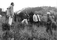
Alex Morley, Paul McCollister, and Willie Schaeffler on the far right, scoping out the mountain about half way up of what is now known as the "Slalom" ski run at Jackson Hole, circa 1961
1959; 1960; 1961; 1962; 1963
Image/StillImage
uum_map_usa
2
Anticline - Five miles east of Cody, Wyo.
1914-06
Image/StillImage
uum_map
3
Anticline - Five miles east of Cody, Wyo.
1914-06
Image/StillImage
uum_map
4
Anticline - Five miles east of Cody, Wyo.
1914-06
Image/StillImage
uum_map
5
Anticline - Sheep Mountain - Wyo
1914-06
Image/StillImage
uum_map
6
Anticline - Sheep Mountain - Wyo
1914-06
Image/StillImage
uum_map
7
Anticline - Sheep Mountain - Wyo
1914-06
Image/StillImage
uum_map
8
Ashley National Forest - Forest Visitor Map 1998
1998
Image/StillImage
ucl_maps
9
Band in front of Lyman High school, Wyoming, circa 1920s
1918; 1919; 1920; 1921; 1922; 1923; 1924; 1925; 1926; 1927; 1928; 1929; 1930; 1931
Image/StillImage
uum_map
10
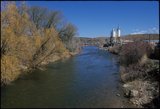
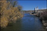
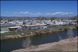
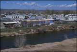
Bear River at Evanston, Wyoming [01]
2002-04-29
Image/StillImage
uum_map
11
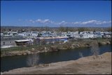
Bear River at Evanston, Wyoming [02]
2002-04-29
Image/StillImage
uum_map
12
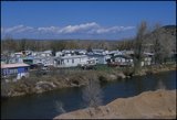
Bear River at Evanston, Wyoming [03]
2002-04-29
Image/StillImage
uum_map
13
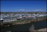
Bear River at Evanston, Wyoming [04]
2002-04-29
Image/StillImage
uum_map
14
Bear River at Evanston, Wyoming [05]
2002-04-29
Image/StillImage
uum_map
15
Bear River at Evanston, Wyoming [06]
2002-04-29
Image/StillImage
uum_map
16
Bear River at Evanston, Wyoming [07]
2002-04-29
Image/StillImage
uum_map
17
Bear River at Evanston, Wyoming [08]
2002-04-29
Image/StillImage
uum_map
18
Bear River at Evanston, Wyoming [09]
2002-04-29
Image/StillImage
uum_map
19
Bear River at Evanston, Wyoming [10]
2002-04-29
Image/StillImage
uum_map
20
Bear River at Evanston, Wyoming [11]
2002-04-29
Image/StillImage
uum_map
21
Bear River at Evanston, Wyoming [12]
2002-04-29
Image/StillImage
uum_map
22
Bear River at Evanston, Wyoming [13]
2002-04-29
Image/StillImage
uum_map
23
Bear River Bottoms south of Evanston (negative) [01]
2001-09-18; 2001-09-19
Image/StillImage
uum_map
24
Bear River Bottoms south of Evanston (negative) [02]
2001-09-18; 2001-09-19
Image/StillImage
uum_map
25
Bear River Bottoms south of Evanston (negative) [03]
2001-09-18; 2001-09-19
Image/StillImage
uum_map
1
-
25
of
616
<
1
2
3
4
5
6
7
8
9
10
>