Home
Browse
Ask Us
Chat
Harmful Language Statement
Log in
Advanced Search
Year
1870
1871
1872
1873
1874
1875
1876
1877
1878
1879
1880
1881
1882
1883
1884
1885
1886
1887
1888
1889
1890
1891
1892
1893
1894
1895
1896
1897
1898
1899
1900
1901
1902
1903
1904
1905
1906
1907
1908
1909
1910
1911
1912
1913
1914
1915
1916
1917
1918
1919
1920
1921
1922
1923
1924
1925
1926
1927
1928
1929
1930
1931
1932
1933
1934
1935
1936
1937
1938
1939
1940
1941
1942
1943
1944
1945
1946
1947
1948
1949
1950
1951
1952
1953
1954
1955
1956
1957
1958
1959
1960
1961
1962
1963
1964
1965
1966
1967
1968
1969
1970
1971
1972
1973
1974
1975
1976
1977
1978
1979
1980
1981
1982
1983
1984
1985
1986
1987
1988
1989
1990
1991
1992
1993
1994
1995
1996
1997
1998
1999
2000
2001
2002
2003
TO
1870
1871
1872
1873
1874
1875
1876
1877
1878
1879
1880
1881
1882
1883
1884
1885
1886
1887
1888
1889
1890
1891
1892
1893
1894
1895
1896
1897
1898
1899
1900
1901
1902
1903
1904
1905
1906
1907
1908
1909
1910
1911
1912
1913
1914
1915
1916
1917
1918
1919
1920
1921
1922
1923
1924
1925
1926
1927
1928
1929
1930
1931
1932
1933
1934
1935
1936
1937
1938
1939
1940
1941
1942
1943
1944
1945
1946
1947
1948
1949
1950
1951
1952
1953
1954
1955
1956
1957
1958
1959
1960
1961
1962
1963
1964
1965
1966
1967
1968
1969
1970
1971
1972
1973
1974
1975
1976
1977
1978
1979
1980
1981
1982
1983
1984
1985
1986
1987
1988
1989
1990
1991
1992
1993
1994
1995
1996
1997
1998
1999
2000
2001
2002
2003
Type
Image
473
Image/StillImage
247
Format
image/jpeg
833
Collection
Beckwith Photograph Collection
45
Photo Archives
585
Ski and Snow Sports Archives
13
UAIDA Main Collection
1
Uintah County Regional History Center...
1
Utah River Running Photo Archives
164
Westminster University Photographs
24
More
Filters:
Format:
"image/jpeg"
Spatial Coverage:
"Washington County (Utah)"
401
-
425
of
833
<
12
13
14
15
16
17
18
19
20
21
>
Gallery view
Number of results to display per page
10
25
50
100
200
Sort by Relevance
Sort by Title A-Z
Sort by Title Z-A
Sort by Date Ascending
Sort by Date Descending
Sort by Last Modified Ascending
Sort by Last Modified Descending
Title
Date
Type
Setname
401
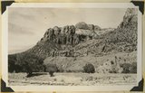
Near Rockville
1936
Image
uum_map
402
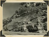
North wall of Parunuweap Canyon. Chinle including Springdale member, first heavy ledge. Wingate, Kayenta, Navajo. Near Stevens Wash, Washington County, Utah.
1936
Image
uum_map
403
Old abandoned cotton mill at Washington, Utah.
1930; 1931; 1932; 1933; 1934; 1935; 1936; 1937
Image
uum_map
404
On Angels Landing trail, Zion [1]
1959-06-24
Image
uum_map
405
On Angels Landing trail, Zion [2]
1959-06-24
Image
uum_map
406
On Angels Landing trail, Zion [3]
1959-06-24
Image
uum_map
407
On Angels Landing trail, Zion [4]
1959-06-24
Image
uum_map
408
On Angels Landing trail, Zion [5]
1959-06-24
Image
uum_map
409
On Angels Landing trail, Zion [6]
1959-06-24
Image
uum_map
410
Oregon-California trip, 1921: Alluvial Cone - Zion Canyon
1921-08-24
Image/StillImage
uum_map
411
Oregon-California trip, 1921: Packs - Auto Camp - Washington, Utah - Sadie, Eugene, Eleanor, Marion, Alvin
1921-08
Image/StillImage
uum_map
412
Oregon-California trip, 1921: Temple - St George - Utah [01]
1921-08
Image/StillImage
uum_map
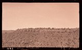
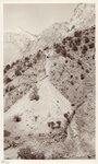
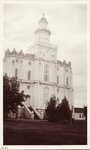
413
Oregon-California trip, 1921: Temple - St George - Utah [02]
1921-08
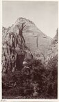
Image/StillImage
uum_map
414
Oregon-California trip, 1921: Zion Canyon [01]
1921-08-24
Image/StillImage
uum_map
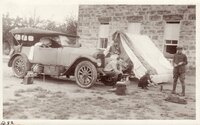
415
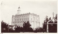
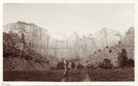
Oregon-California trip, 1921: Zion Canyon [02]
1921-08-24
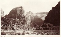
Image/StillImage
uum_map
416
Oregon-California trip, 1921: Zion Canyon [03]
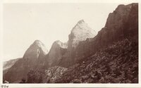
1921-08-24
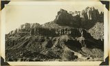
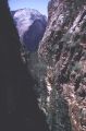
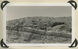
Image/StillImage
uum_map
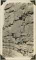
417
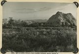
Oregon-California trip, 1921: Zion Canyon [04]
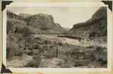
1921-08-24
Image/StillImage
uum_map
418
Overhead cliff near Emerald Pools, Zion
1959-06-24
Image
uum_map
419
Panorama (upper and lower halves), Box canyon of Parunuweap just below "lower falls."
1926
Image
uum_map
420
Part of Chinle formation above Springdale member; sandstone, shales and lime conglomerates. Pine Valley. Zion National Park, 1938
1938
Image
uum_map
421
Part of Chinle formation just above variagated shales in wall of Virgin River Canyon, Springdale, Washington County, Utah, 1930.
1930
Image
uum_map
422
Part of Kolob volcanic field looking southeast across canyons of Virgin River to Moccasin Terrace (skyline). Lava (foreground) has buried rough topography developed on Chinle and Navajo. Above it rises island like Pine Valley Peak of Navajo sandstone (upper right). Towers of Zion (upper left). Washington County, UT, 1942
1942
Image
uum_map
423
Parunuweap Canyon near east boundary of Zion Park, Utah, 1936.
1936
Image
uum_map
424
Parunuweap Canyon, looking NW toward the Watchman. Springdale member center cliffs, Utah, 1936.
1936
Image
uum_map
425
Parunuweap formation overlying Moenkopi; on divide between two tributaries to Virgin River near Grafton. Washington County, UT, 1942
1942
Image
uum_map
401
-
425
of
833
<
12
13
14
15
16
17
18
19
20
21
>