Home
Browse
Ask Us
Chat
Harmful Language Statement
Log in
Advanced Search
Year
1870
1871
1872
1873
1874
1875
1876
1877
1878
1879
1880
1881
1882
1883
1884
1885
1886
1887
1888
1889
1890
1891
1892
1893
1894
1895
1896
1897
1898
1899
1900
1901
1902
1903
1904
1905
1906
1907
1908
1909
1910
1911
1912
1913
1914
1915
1916
1917
1918
1919
1920
1921
1922
1923
1924
1925
1926
1927
1928
1929
1930
1931
1932
1933
1934
1935
1936
1937
1938
1939
1940
1941
1942
1943
1944
1945
1946
1947
1948
1949
1950
1951
1952
1953
1954
1955
1956
1957
1958
1959
1960
1961
1962
1963
1964
1965
1966
1967
1968
1969
1970
1971
1972
1973
1974
1975
1976
1977
1978
1979
1980
1981
1982
1983
1984
1985
1986
1987
1988
1989
1990
1991
1992
1993
1994
1995
1996
1997
1998
1999
2000
2001
2002
2003
TO
1870
1871
1872
1873
1874
1875
1876
1877
1878
1879
1880
1881
1882
1883
1884
1885
1886
1887
1888
1889
1890
1891
1892
1893
1894
1895
1896
1897
1898
1899
1900
1901
1902
1903
1904
1905
1906
1907
1908
1909
1910
1911
1912
1913
1914
1915
1916
1917
1918
1919
1920
1921
1922
1923
1924
1925
1926
1927
1928
1929
1930
1931
1932
1933
1934
1935
1936
1937
1938
1939
1940
1941
1942
1943
1944
1945
1946
1947
1948
1949
1950
1951
1952
1953
1954
1955
1956
1957
1958
1959
1960
1961
1962
1963
1964
1965
1966
1967
1968
1969
1970
1971
1972
1973
1974
1975
1976
1977
1978
1979
1980
1981
1982
1983
1984
1985
1986
1987
1988
1989
1990
1991
1992
1993
1994
1995
1996
1997
1998
1999
2000
2001
2002
2003
Type
Image
473
Image/StillImage
247
Format
image/jpeg
833
Collection
Beckwith Photograph Collection
45
Photo Archives
585
Ski and Snow Sports Archives
13
UAIDA Main Collection
1
Uintah County Regional History Center...
1
Utah River Running Photo Archives
164
Westminster University Photographs
24
More
Filters:
Format:
"image/jpeg"
Spatial Coverage:
"Washington County (Utah)"
326
-
350
of
833
<
9
10
11
12
13
14
15
16
17
18
>
Gallery view
Number of results to display per page
10
25
50
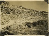
100
200
Sort by Relevance
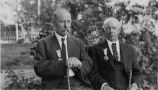
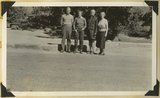
Sort by Title A-Z
Sort by Title Z-A
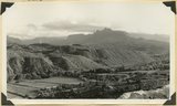
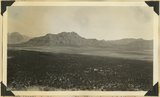
Sort by Date Ascending
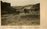
Sort by Date Descending
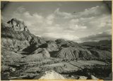
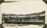
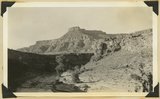
Sort by Last Modified Ascending
Sort by Last Modified Descending
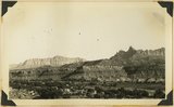
Title
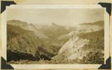
Date
Type
Setname
326
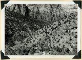
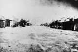
Landslide at mouth of Parunuweap (right center) extends from south of Springdale (foreground) across Parunuweap to base of Eagle Crags (top center). Involves entire Chinle formation. Washington County, UT. 1939
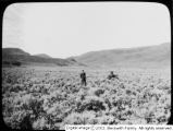
1939
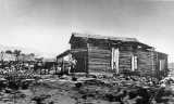
Image
uum_map
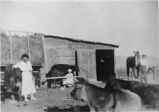
327
Landslide in Chinle formation from base of Navajo Mountains Sandstone, Springdale member of Chinle (middle right). Near headquarters, Zion National Park, UT. 1939
1939
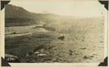
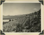
Image
uum_map
328
Landslide, 1 mile south of Springdale, covers strata from base of Navajo (top left) to Shinarump. Springdale member of Chinle (left middle). Washington County, UT. 1939
1939
Image
uum_map
329
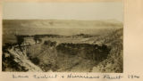
Lava Contact & Hurricane Fault, 1900
1900
Image
uum_map
330
Lava flow over gravel wash. South of Toquerville, Utah, along main road from Zion Canyon to Anderson's Ranch.
1930; 1931; 1932; 1933; 1934; 1935; 1936; 1937
Image
uum_map
331
Left: George Guglielmo San Giovani; Right: Horatio Pickett
1912-09
Image
uum_map
332
Limestone near base of Timpoweap member of the Moenkopi formation, Alkali Wash. Washington County, Utah, 1938.
1938
Image
uum_map
333
Looking across Big Plains toward Smithsonian Butte (middle background), West Temple (upper right). Foreground forested east slope of Little Creek Mountain, Shinarump; middle distance, dry farm lands on Chinle strata. Washington County, Utah, 1937.
1937
Image
uum_map
334
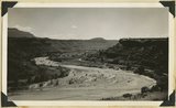
Looking down Virgin River 1900
1900
Image
uum_map
335
Looking north across Timpoweap Canyon: foreground Kaibab; middle flat, base of Moenkopi red shales; distance, Moenkopi capped by Shinarump; platform at upper left, Virgin limestone member. Washington County, Utah, 1937.
1937
Image
uum_map
336
Looking south from old park headquarters, Zion
1959-06-24
Image
uum_map
337
Looking southeast across Rockville, Moenkopi (at river), Shinarump (mesa caps), Chinle (broken slopes), Navajo (top), showing Eagle Crag (right), and South Mountain (left), Washington County, Utah, 1936.
1936
Image
uum_map
338
Looking west down Parunuweap from point 4 miles above junction at Rockville.
1926
Image
uum_map
339
Looking west from Horse Pasture toward Guardian Angel, 1936.
1936
Image
uum_map
340
Lower red beds of the Moenkopi formation near mouth of Taylor Creek, flat land (left center), on downthrow side of Hurricane fault, Kanarraville. Washington County, UT, 1940
1940
Image
uum_map
341
Lowery and Gregory, Virgin City, 1937.
1937
Image
uum_map
342
Main Street of Silver Reef, Utah.
1880; 1881; 1882; 1883; 1884; 1885
uum_map
343
Man on horseback watching cattle graze at the shore of the Rio Virgin.
1909-09
uum_map
344
Man standing on the porch of a log cabin in Silver Reef, Utah.
1880; 1881; 1882; 1883; 1884; 1885; 1886; 1887; 1888; 1889; 1890
uum_map
345
Martin McAllister, William Thompson and Samuel Wells as they appeared in the musical "Rob-Roy McGregor" produced by Thompson's Band of St. George, Utah, 1890s.
1890; 1891; 1892; 1893; 1894; 1895; 1896; 1897; 1898; 1899; 1900
Image
uum_map
346
Massacre Hill
Image
dc_bpc
347
Maud Bigler in the play "Capitola", St. George, Utah, 1890s
1890; 1891; 1892; 1893; 1894; 1895; 1896; 1897; 1898; 1899; 1900
Image
uum_map
348
Meadow land along upper Kolob Creek, developed in Tropic shale, Washington County, UT, 1939
1939
Image
uum_map
349
Meanders of the Virgin River, near Rockville. Moenkopi capped by Shinarump. Washington County, Utah, 1936.
1936
Image
uum_map
350
Members of the Burascano family in St. George, Utah.
Image
uum_map
326
-
350
of
833
<
9
10
11
12
13
14
15
16
17
18
>