Home
Browse
Ask Us
Chat
Harmful Language Statement
Log in
Advanced Search
Year
1922
1923
1924
1925
1926
1927
1928
1929
1930
1931
1932
1933
1934
1935
1936
1937
1938
1939
1940
1941
1942
1943
1944
1945
1946
1947
1948
1949
1950
1951
1952
1953
1954
1955
1956
1957
1958
1959
1960
TO
1922
1923
1924
1925
1926
1927
1928
1929
1930
1931
1932
1933
1934
1935
1936
1937
1938
1939
1940
1941
1942
1943
1944
1945
1946
1947
1948
1949
1950
1951
1952
1953
1954
1955
1956
1957
1958
1959
1960
Type
Image
25
Image/StillImage
1
Format
image/jpeg
26
Collection
Al W. Morton Collection, 1930s-1950s
1
Photo Archives
25
Filters:
Format:
"image/jpeg"
Spatial Coverage:
"Virgin River"
1
-
25
of
26
<
1
2
>
Gallery view
Number of results to display per page
10
25
50
100
200
Sort by Relevance
Sort by Title A-Z
Sort by Title Z-A
Sort by Date Ascending
Sort by Date Descending
Sort by Last Modified Ascending
Sort by Last Modified Descending
Title
Date
Type
Setname
1
Virgin River
1950; 1951; 1952; 1953; 1954; 1955; 1956; 1957; 1958; 1959; 1960
Image/StillImage
dha_alwmc
2
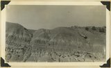
"Marls" in Chinle formation, Springdale, Washington County, Utah, 1936.
1936
Image
uum_map
3
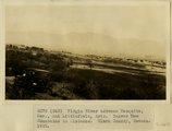
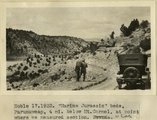
Virgin River near Littlefield. Mojave County, AZ. 1922
1922
Image
uum_map
4
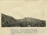
Bank of Virgin River near Mt. Carmel. Marine Jurassic overlying Navajo sandstone. Kane County, UT. 1922
1922
Image
uum_map
5
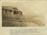
Bank of Virgin River. Road cut in Pliocene(?) wash deposits. 4 miles south of Littlefield. Mojave County, AZ. 1922
1922
Image
uum_map
6
Virgin River between Mesquite, NV and Littlefield, AZ. Beaver Dam Mountains in distance. Clark County, NV. 1922
1922
Image
uum_map
7
Virgin River near Mesquite, Nev. Beaver Dam Mountains in distance. Clark County, NV. 1922
1922
Image
uum_map
8
'Marine Jurassic' beds, Paunuweap, 4 miles below Mt. Carmel., at point where we measured section. UT
1922
Image
uum_map
9
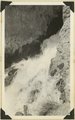
Cascade Falls, source of Virgin River. Point of emergence from Wasatch limestone. Garfield County, Utah, 1937.
1937
Image
uum_map
10
Head of canyon of Virgin River near Mt. Carmel. Marine Jurassic overlying Navajo sandstone. Kane County, UT. 1922
1922
Image
uum_map
11
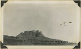
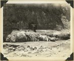
The Hurricane Fault where it crosses the Virgin River. La Verkin Warm Sulphur Springs in canyon.
1930; 1931; 1932; 1933; 1934; 1935; 1936; 1937
Image
uum_map
12
Moenkopi capped by Shinarump. Coalpits volcano in distance. Virgin River in foreground. Rockville, Washington County, Utah, 1936.
1936
Image
uum_map
13
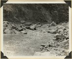
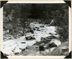
Virgin River in Zion National Park: erosion of land slide at flood stage
1937; 1938
Image
uum_map
14
Virgin River in Zion National Park: flood stage
1937; 1938
Image
uum_map
15
Virgin River in Zion National Park: flood stage
1937; 1938
Image
uum_map
16
Virgin River in Zion National Park: rising flood from shower on Kolob Terrace
1937; 1938
Image
uum_map
17
Virgin River in Zion National Park: rising flood from shower on Kolob Terrace
1937; 1938
Image
uum_map
18
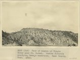
Grafton fault at west end of Smithsonian Butte, looking northward across Virgin River. Coalpits volcano in middle background, edge of Kolob plateau in distance. Washington County, Utah, 1936.
1936
Image
uum_map
19
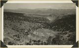
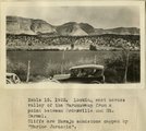
Looking east across valley of the Parunuweap from a point between Orderville and Mt. Carmel. Cliffs are Navajo sandstone capped by 'Marine Jurassic'
1922
Image
uum_map
20
View looking north across Virgin River at Rockville. Foreground, Moenkopi capped by Shinarump; middle distance, Chinle; distance, Navajo forming Mount Kinesava. Washington County, Utah, 1936.
1936
Image
uum_map
21
Virgin River at La Verkin Hot Springs. Shacks are shelters over intake pipes leading to the pool quarter of a mile down the river. Washington County, Utah, 1937.
1937
Image
uum_map
22
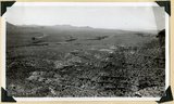
Wash of Virgin River at Grafton, 30 feet wide in 1860, now 1000 feet wide, Moenkopi forms banks, Navajo beyond, Washington County, Utah, 1930.
1930; 1931; 1932; 1933; 1934; 1935; 1936; 1937
Image
uum_map
23
Site of Springdale, Virgin River Valley, below mouth of Zion Canyon. At left, the Watchman. Navajo sandstone, underlaid by Chinle: middle cliff is Springdale member. Washington County, UT
1937; 1938
Image
uum_map
24
Source of the Virgin River. Looking northwest along Cascade Falls Trail. Spring issues from Wasatch limestone cliffs of Markagunt Plateau. Garfield County, Utah, 1937.
1937
Image
uum_map
25
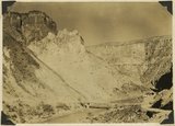
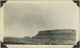
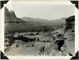
View looking S-SW from foothills 2 miles west of Virgin City. Shnabkaib member of Moenkopi (foreground). Timpoweap member of Moenkopi into which Timpoweap Canyon of the Virgin River is cut (middle distance). Sugar Loaf and other lava capped mesas (left distance)' crest of Hurricane Cliffs (right distance), Washington County, UT, 1938
1938
Image
uum_map
1
-
25
of
26
<
1
2
>