Home
Browse
Ask Us
Chat
Harmful Language Statement
Log in
Advanced Search
Year
1863
1864
1865
1866
1867
1868
1869
1870
1871
1872
1873
1874
1875
1876
1877
1878
1879
1880
1881
1882
1883
1884
1885
1886
1887
1888
1889
1890
1891
1892
1893
1894
1895
1896
1897
1898
1899
1900
1901
1902
1903
1904
1905
1906
1907
1908
1909
1910
1911
1912
1913
1914
1915
1916
1917
1918
1919
1920
1921
1922
1923
1924
1925
1926
1927
1928
1929
1930
1931
1932
1933
1934
1935
1936
1937
1938
1939
1940
1941
1942
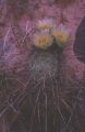
1943
1944
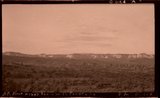
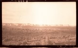
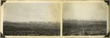
1945
1946
1947
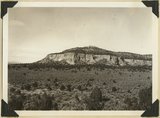
1948
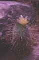
1949
1950
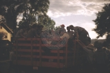
1951
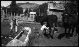
1952
1953
1954
1955
1956
1957
1958
1959
1960
1961
1962
1963
1964
1965
1966
1967
1968
1969
1970
1971
1972
1973
1974
1975
1976
1977
1978
1979
1980
1981
1982
1983
1984
1985
1986
1987
1988
1989
1990
1991
TO
1863
1864
1865
1866
1867
1868
1869
1870
1871
1872
1873
1874
1875
1876
1877
1878
1879
1880
1881
1882
1883
1884
1885
1886
1887
1888
1889
1890
1891
1892
1893
1894
1895
1896
1897
1898
1899
1900
1901
1902
1903
1904
1905
1906
1907
1908
1909
1910
1911
1912
1913
1914
1915
1916
1917
1918
1919
1920
1921
1922
1923
1924
1925
1926
1927
1928
1929
1930
1931
1932
1933
1934
1935
1936
1937
1938
1939
1940
1941
1942
1943
1944
1945
1946
1947
1948
1949
1950
1951
1952
1953
1954
1955
1956
1957
1958
1959
1960
1961
1962
1963
1964
1965
1966
1967
1968
1969
1970
1971
1972
1973
1974
1975
1976
1977
1978
1979
1980
1981
1982
1983
1984
1985
1986
1987
1988
1989
1990
1991
Type
Image
1,241
Image/StillImage
112
Format
image/jpeg
1,411
Collection
Beckwith Photograph Collection
9
Photo Archives
1,248
Utah River Running Photo Archives
152
Westminster University Photographs
2
Filters:
Format:
"image/jpeg"
Spatial Coverage:
"Kane County (Utah)"
76
-
100
of
1,411
<
1
2
3
4
5
6
7
8
9
10
>
Gallery view
Number of results to display per page
10
25
50
100
200
Sort by Relevance
Sort by Title A-Z
Sort by Title Z-A
Sort by Date Ascending
Sort by Date Descending
Sort by Last Modified Ascending
Sort by Last Modified Descending
Title
Date
Type
Setname
76
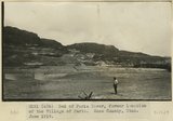
Bed of Paria River, former location of the Village of Paria. Kane County, UT. June 1918
1918
Image
uum_map
77
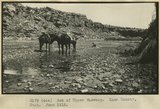
Bed of Upper Wahweap. Kane County, UT. June 1918
1918
Image
uum_map
78
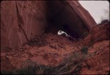
Below to Gregory Bridge from large cove downstream
1963-04-23
Image
uum_map
79
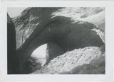
Bement Arch
1963
Image
uum_map
80
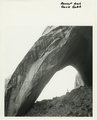
Bement Arch, Davis Gulch
1940; 1941; 1942; 1943; 1944; 1945; 1946; 1947; 1948; 1949; 1950; 1951; 1952; 1953; 1954; 1955; 1956; 1957; 1958; 1959; 1960; 1961; 1962; 1963; 1964; 1965; 1966; 1967; 1968; 1969; 1970; 1971; 1972; 1973; 1974; 1975; 1976; 1977; 1978; 1979; 1980
Image
uum_map
81
Bement Arch, Davis Gulch
1940; 1941; 1942; 1943; 1944; 1945; 1946; 1947; 1948; 1949; 1950; 1951; 1952; 1953; 1954; 1955; 1956; 1957; 1958; 1959; 1960; 1961; 1962; 1963; 1964; 1965; 1966; 1967; 1968; 1969; 1970; 1971; 1972; 1973; 1974; 1975; 1976; 1977; 1978; 1979; 1980
Image
uum_map
82
Bement Arch, Davis Gulch
1964-05
Image
uum_map
83
Bench extending from Kaiparowits Plateau near Fifty Mile Point. Kane County, UT. June 1918
1918
Image
uum_map
84
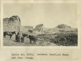
Between Gunsight Pass and Kane Creek
1922
Image
uum_map
85
Beveled erosion surface above alluvium flat into which is cut Deer Range wash. Kane County, Utah, 1934.
1934
Image
uum_map
86
Big Meadow Canyon. Carmel formation. Kane County, Utah.
1930
Image
uum_map
87
Big Plains, west dipping surface eroded on east dipping Chinle beds, now coated with coalescing fans. Little Creek Terrace in right background, Kane County, UT, 1939
1939
Image
uum_map
88
Blackbrush in bloom, Hidden Passage Bar [1]
1963-04-25
Image
uum_map
89
Blackbrush in bloom, Hidden Passage Bar [2]
1963-04-25
Image
uum_map
90
Block mesas from south, panorama.
1937
Image
uum_map
91
Block mesas from south, panorama.
1937
Image
uum_map
92
Block mesas from the south, panorama.
1937
Image
uum_map
93
Block Mesas, east of Elephant Gap. Navajo sandstone capped by Carmel. Kane County, Utah, 1936.
1936
Image
uum_map
94
Blooming hedgehog cactus in Forbidden Canyon [1]
1963-04-25
Image
uum_map
95
Blooming hedgehog cactus in Forbidden Canyon [2]
1963-04-25
Image
uum_map
96
Boarding stake-bed truck to return to Salt Lake City on top of all the trip gear.
1954-07
Image
uum_map_rr
97
Boy at Esplin home in Orderville
Image
uum_map
98
Boy with a melon
Image
uum_map
99
Breakfast in the rain (refreshing!)
1985-05-10; 1985-05-11; 1985-05-12
Image
uum_map
100
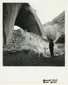
Brian Head formation, consolidated (white wall) and disintegrated (upper slopes), and pink Wasatch limestones (lowest slopes). Seamans Canyon west of Gravel Pass. Kane County, UT, 1944
1944
Image
uum_map
76
-
100
of
1,411
<
1
2
3
4
5
6
7
8
9
10
>