Home
Browse
Ask Us
Chat
Harmful Language Statement
Log in
Advanced Search
Year
1853
1854
1855
1856
1857
1858
1859
1860
1861
1862
1863
1864
1865
1866
1867
1868
1869
1870
1871
1872
1873
1874
1875
1876
1877
1878
1879
1880
1881
1882
1883
1884
1885
1886
1887
1888
1889
1890
1891
1892
1893
1894
1895
1896
1897
1898
1899
1900
1901
1902
1903
1904
1905
1906
1907
1908
1909
1910
1911
1912
1913
1914
1915
1916
1917
1918
1919
1920
1921
1922
1923
1924
1925
1926
1927
1928
1929
1930
1931
1932
1933
1934
1935
1936
1937
1938
1939
1940
1941
1942
1943
1944
1945
1946
1947
1948
1949
1950
1951
1952
1953
1954
1955
1956
1957
1958
1959
1960
1961
1962
1963
1964
1965
1966
1967
1968
1969
1970
1971
1972
1973
1974
1975
1976
1977
1978
1979
1980
1981
1982
1983
1984
1985
1986
1987
1988
1989
1990
1991
1992
1993
1994
1995
1996
1997
1998
TO
1853
1854
1855
1856
1857
1858
1859
1860
1861
1862
1863
1864
1865
1866
1867
1868
1869
1870
1871
1872
1873
1874
1875
1876
1877
1878
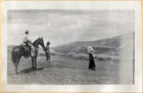
1879
1880
1881
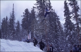
1882
1883
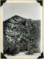
1884
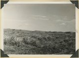
1885
1886
1887
1888
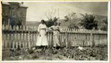
1889
1890
1891
1892
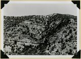
1893
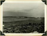
1894
1895
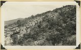
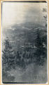
1896
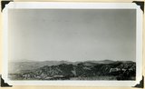
1897
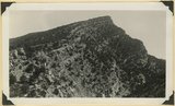
1898
1899
1900
1901
1902
1903
1904
1905
1906
1907
1908
1909
1910
1911
1912
1913
1914
1915
1916
1917
1918
1919
1920
1921
1922
1923
1924
1925
1926
1927
1928
1929
1930
1931
1932
1933
1934
1935
1936
1937
1938
1939
1940
1941
1942
1943
1944
1945
1946
1947
1948
1949
1950
1951
1952
1953
1954
1955
1956
1957
1958
1959
1960
1961
1962
1963
1964
1965
1966
1967
1968
1969
1970
1971
1972
1973
1974
1975
1976
1977
1978
1979
1980
1981
1982
1983
1984
1985
1986
1987
1988
1989
1990
1991
1992
1993
1994
1995
1996
1997
1998
Type
Image
210
Format
image/jpeg
210
Collection
Beckwith Photograph Collection
48
Photo Archives
154
Ski and Snow Sports Archives
4
Westminster University Photographs
4
Filters:
Format:
"image/jpeg"
Spatial Coverage:
"Iron County (Utah)"
Type:
"Image"
176
-
200
of
210
<
1
2
3
4
5
6
7
8
9
>
Gallery view
Number of results to display per page
10
25
50
100
200
Sort by Relevance
Sort by Title A-Z
Sort by Title Z-A
Sort by Date Ascending
Sort by Date Descending
Sort by Last Modified Ascending
Sort by Last Modified Descending
Title
Date
Type
Setname
176
Surface of Kolob Terrace showing sharp drop to heads of deep canyons. Lava in foreground, Washington County, UT. 1939
1939
Image
uum_map
177
Surface of Kolob Terrace. Divide between North Creek and Kolob Creek, Washington County, UT. 1939
1939
Image
uum_map
178
Surface of the Piute Highlands looking north from Mithcell Ridge, Iron County, UT, 1942
1942
Image
uum_map
179
Talus of blocks from basalt sheet. Square Mountain. Iron County, UT. 1941
1941
Image
uum_map
180
Termination of a basalt flow from Hancock Peak, overriding Wasatch limestone, left. Branch of Mammoth Creek, Iron County, UT, 1942
1942
Image
uum_map
181
Three people, a horse and a gun on Cedar Mountain, perhaps on the way from Esplin ranch
Image
uum_map
182
Tilted Cretaceous strata that terminate westward left at the Hurricane fault. Canyon southeast of Summit, Iron County, UT. 1942
1942
Image
uum_map
183
Tilted Cretaceous strata that terminate westward left at the Hurricane fault. Canyon southeast of Summit, Iron County, UT. 1942. Wall of Fiddler Canyon
1942
Image
uum_map
184
Tommy Viele snowboarding at Brian Head, 1998.
1998
Image
uum_map_usa
185
Tommy Viele snowboarding at Brian Head, 1998.
1998
Image
uum_map_usa
186
Top of Brian Head (11,280 feet) showing fracture of rhyolite by frost. Iron County, UT. 1941
1941
Image
uum_map
187
Top of ridge near head of Lauder Valley showing frost work and vegetation on Markagunt Plateau at altitudes between 10,000 and 11,000 feet. Iron County, UT, 1941
1941
Image
uum_map
188
Turkey tracks [1]
Image
dc_bpc
189
Turkey tracks [2]
Image
dc_bpc
190
Two men and a horse - likely on Cedar Mtn in Iron County
Image
uum_map
191
Two women in Cedar City
Image
uum_map
192
Undifferentiated Cretaceous formation near mouth of Parowan Canyon. Iron County, UT
1941
Image
uum_map
193
Undifferentiated Cretaceous formation near mouth of Parowan Canyon. Iron County, UT
1941
Image
uum_map
194
Valley - Cedar Mtn
Image
uum_map
195
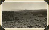
View looking north from near head of South Creek across Coal Canyon, Iron County, UT
1941; 1942
Image
uum_map
196
View looking northeast across Kolob Terrace developed on Cretaceous strata. Pink Cliffs Tertiary (skyline), Black Mountain Volcano (upper left). Iron County, UT, 1942
1942
Image
uum_map
197
View looking northeast across Kolob Terrace. Basalt (foreground), Cretaceous trenched by Crystal Creek (middle), Pink Cliffs-Wasatch (skyline), lower east slope of Black Mountain (extreme left), 'The Gap,' twin peaks (right skyline), stands just south of Navajo Lake. Iron County, UT, 1942
1942
Image
uum_map
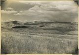
198
View north along the rim of Markagunt Plateau from Brian Head. Iron County, Utah, 1937.
1937
Image
uum_map
199
View south from the base of Horseranch Mountain, across the three deep canyon branches of Taylor Creek. Timber Top Mesa (middle skyline); Navajo sandstone (in walls); Carmel (general surface); Entrada (left center); Smith Mesa, Triassic rocks (upper right); towers of Zion National Park (upper left). Iron County, UT, 1942
1942
Image
uum_map
200
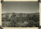
View southeast from top of Brian Head. Hancock Peak in center middle distance; Paunsaugunt Plateau on left horizon. Iron County, Utah, 1936.
1936
Image
uum_map
176
-
200
of
210
<
1
2
3
4
5
6
7
8
9
>