Home
Browse
Ask Us
Chat
Harmful Language Statement
Log in
Advanced Search
Year
1853
1854
1855
1856
1857
1858
1859
1860
1861
1862
1863
1864
1865
1866
1867
1868
1869
1870
1871
1872
1873
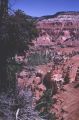
1874
1875
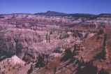
1876
1877
1878
1879
1880
1881
1882
1883
1884
1885
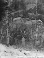
1886
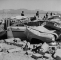
1887
1888
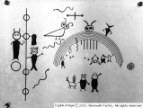
1889
1890
1891
1892
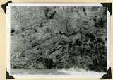
1893
1894
1895
1896
1897
1898
1899
1900
1901
1902
1903
1904
1905
1906
1907
1908
1909
1910
1911
1912
1913
1914
1915
1916
1917
1918
1919
1920
1921
1922
1923
1924
1925
1926
1927
1928
1929
1930
1931
1932
1933
1934
1935
1936
1937
1938
1939
1940
1941
1942
1943
1944
1945
1946
1947
1948
1949
1950
1951
1952
1953
1954
1955
1956
1957
1958
1959
1960
1961
1962
1963
1964
1965
1966
1967
1968
1969
1970
1971
1972
1973
1974
1975
1976
1977
1978
1979
1980
1981
1982
1983
1984
1985
1986
1987
1988
1989
1990
1991
1992
1993
1994
1995
1996
1997
1998
TO
1853
1854
1855
1856
1857
1858
1859
1860
1861
1862
1863
1864
1865
1866
1867
1868
1869
1870
1871
1872
1873
1874
1875
1876
1877
1878
1879
1880
1881
1882
1883
1884
1885
1886
1887
1888
1889
1890
1891
1892
1893
1894
1895
1896
1897
1898
1899
1900
1901
1902
1903
1904
1905
1906
1907
1908
1909
1910
1911
1912
1913
1914
1915
1916
1917
1918
1919
1920
1921
1922
1923
1924
1925
1926
1927
1928
1929
1930
1931
1932
1933
1934
1935
1936
1937
1938
1939
1940
1941
1942
1943
1944
1945
1946
1947
1948
1949
1950
1951
1952
1953
1954
1955
1956
1957
1958
1959
1960
1961
1962
1963
1964
1965
1966
1967
1968
1969
1970
1971
1972
1973
1974
1975
1976
1977
1978
1979
1980
1981
1982
1983
1984
1985
1986
1987
1988
1989
1990
1991
1992
1993
1994
1995
1996
1997
1998
Type
Image
210
Format
image/jpeg
210
Collection
Beckwith Photograph Collection
48
Photo Archives
154
Ski and Snow Sports Archives
4
Westminster College Photographs
4
Filters:
Format:
"image/jpeg"
Spatial Coverage:
"Iron County (Utah)"
Type:
"Image"
26
-
50
of
210
<
1
2
3
4
5
6
7
8
9
>
Gallery view
Number of results to display per page
10
25
50
100
200
Sort by Relevance
Sort by Title A-Z
Sort by Title Z-A
Sort by Date Ascending
Sort by Date Descending
Sort by Last Modified Ascending
Sort by Last Modified Descending
Title
Date
Type
Setname
26
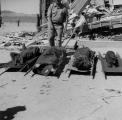
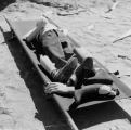
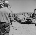
Casualties (dummies). (Johnson covered this open-air test in Nevada for radio station KSUB of Cedar City, Utah.)
1952-04-22
Image
uum_map
27
Casualties (dummies). (Johnson covered this open-air test in Nevada for radio station KSUB of Cedar City, Utah.)
1952-04-22
Image
uum_map
28
Casualties (dummies). (Johnson covered this open-air test in Nevada for radio station KSUB of Cedar City, Utah.)
1952-04-22
Image
uum_map
29
Cedar Breaks and Bristlecone pine
1966-07-04
Image
uum_map
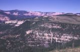
30
Cedar Breaks from a long way off
1966-07-04
Image
uum_map
31
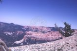
Cedar Breaks National Monument view
1966-07-04
Image
uum_map
32
Cedar Breaks view
1966-07-04
Image
uum_map
33
Cedar Breaks, view along two-mile trail
1966-07-04
Image
uum_map
34
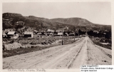
Cedar City View from the North
Image
wc_pc
35
Cedar City, Iron County, Utah: Utah Power & Light photos [07]
1990-10-31
Image
uum_map
36
Cedar City, Iron County, Utah: Utah Power & Light photos [08]
1990-10-31
Image
uum_map
37
Cedar City, Iron County, Utah: Utah Power & Light photos [09]
1990-10-31
Image
uum_map
38
Cone of bristlecone pine, Cedar Breaks
1966-07-04
Image
uum_map
39
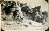
Conglomerate and underlying arkosic sandstone, Kaiparowits formation, Bowery Canyon, Iron County, UT, 1942
1942
Image
uum_map
40
Conglomerate within the Wasatch formation (top and bottom). Bowery Canyon. Iron County, UT, 1942
1942
Image
uum_map
41
Contact of Triassic and Permian (beds in wall wrinkled at base). Cherty limestone lower left. Camp Creek. Iron County, UT. 1941
1941
Image
uum_map
42
Damage to cars and buildings. (Johnson covered this open-air test in Nevada for radio station KSUB of Cedar City, Utah.)
1952-04-22
Image
uum_map
43
Damage to cars and buildings. (Johnson covered this open-air test in Nevada for radio station KSUB of Cedar City, Utah.)
1952-04-22
Image
uum_map
44
Edge of rainbow [1]
1929-12-09
Image
dc_bpc
45
Edge of rainbow [2]
1929-12-09
Image
dc_bpc
46
Emigration Canyon Railway car on the way to the Summit.
1909-07-24
Image
uum_map
47
Exploring
1929-10-12
Image
dc_bpc
48
Face of Hurricane Cliffs between Kanarra and Murie Creeks. Westward dipping lower Moenkopi strata. Edge of South Hills (left center), Square Mountain (left distance). Iron County, UT, 1942
1942
Image
uum_map
49
Fault contact of Carmel (right) and Curtis (left). Coal Canyon above the mouth of Rocky Hollow. Iron County, UT, 1942
1942
Image
uum_map
50
Fault near the mouth of Maple Canyon looking north, upthrown block at left. Iron County, UT, 1942
1942
Image
uum_map
26
-
50
of
210
<
1
2
3
4
5
6
7
8
9
>