1 - 25 of 9
Number of results to display per page
| Title | Date | Type | Setname | ||
|---|---|---|---|---|---|
| 1 | 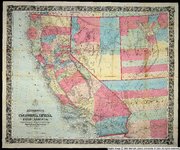 | Bancroft's map of California, Nevada, Utah and Arizona | 1864 | Image | uu_awm |
| 2 |  | California Garden | 1980 | Image/StillImage | uu_uap |
| 3 | 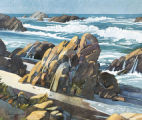 | California Shoreline | 1980 | Image/StillImage | uu_uap |
| 4 | 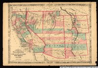 | Johnson's California, with Utah, Nevada, Colorado, New Mexico, and Arizona. | 1864 | Image/StillImage | uu_awm |
| 5 | 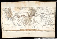 | Karte zu Balduin Mollhausen's Reise vom Mississippi nach der Kuste der Sudsee im Jahre 1853-1854 | 1854 | Image/StillImage | uu_awm |
| 6 | 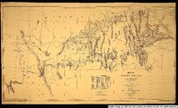 | Map of wagon routes in Utah Territory explored and opened by Capt. J. H. Simpson...in 1858-59. | 1859 | Image/StillImage | uu_awm |
| 7 | 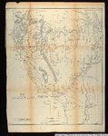 | Map showing the different routes travelled over by the detachments of the Overland Command in the spring of 1855 from Salt Lake City, Utah, to the Bay of San Francisco. | 1855 | Image/StillImage | uu_awm |
| 8 | 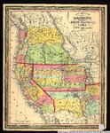 | New map of the state of California, the territories of Oregon, Washington, Utah & New Mexico. | 1853 | Image/StillImage | uu_awm |
| 9 | 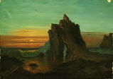 | Sunset on the Coast- California | Image/StillImage | uu_uap |
1 - 25 of 9