|
|
Title | Collection Number And Name | Photo Number |
| 51 |
 |
Same as 2779. Detail contact of conglomerate (foreground) and rough bedded, carbonaceous sandstone above | P0013 Herbert E. Gregory Photograph Collection | P0013n11_163_2781 |
| 52 |
 |
Same as 2779. Detail contact of conglomerate (foreground) and rough bedded, carbonaceous sandstone above | P0013 Herbert E. Gregory Photograph Collection | P0013n11_164_2782 |
| 53 |
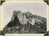 |
Kaiparowits formation unconformable below Wasatch limestone south, foot of Parowan Canyon, Iron County, UT. 1941 | P0013 Herbert E. Gregory Photograph Collection | P0013n11_164_2783 |
| 54 |
 |
Undifferentiated Cretaceous formation near mouth of Parowan Canyon. Iron County, UT | P0013 Herbert E. Gregory Photograph Collection | P0013n11_165_2784 |
| 55 |
 |
Undifferentiated Cretaceous formation near mouth of Parowan Canyon. Iron County, UT | P0013 Herbert E. Gregory Photograph Collection | P0013n11_165_2785 |
| 56 |
 |
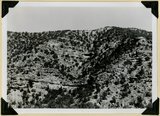
Fault, Wasatch limestone (extreme right) in horizontal contact with undifferentiated Cretaceous. Parowan Canyon. Iron County, UT | P0013 Herbert E. Gregory Photograph Collection | P0013n11_166_2786 |
| 57 |
 |
Fault, Wasatch limestone (extreme right) in horizontal contact with undifferentiated Cretaceous. Parowan Canyon. Iron County, UT | P0013 Herbert E. Gregory Photograph Collection | P0013n11_166_2787 |
| 58 |
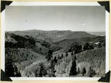 |
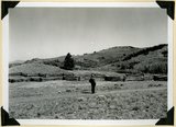
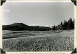
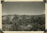
Summit Ridge. View looking south across Braffitts Canyon. Iron County, UT | P0013 Herbert E. Gregory Photograph Collection | P0013n11_167_2788 |
| 59 |
 |
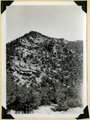
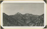
Summit Ridge. Undissected highland 9000 feet near head of Summit Canyon, Iron County | P0013 Herbert E. Gregory Photograph Collection | P0013n11_167_2789 |
| 60 |
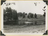 |
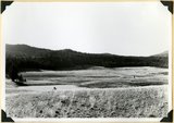
Summit Ridge. Pond supplied chiefly by melting snow. Iron County | P0013 Herbert E. Gregory Photograph Collection | P0013n11_168_2790 |
| 61 |
 |
Summit Ridge. Pond supplied chiefly by melting snow. Iron County | P0013 Herbert E. Gregory Photograph Collection | P0013n11_168_2791 |
| 62 |
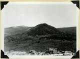 |
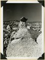
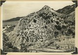
Sugar loaf on outlier of Markagunt Plateau on divide between Parowan and Coal Creek drainage areas. Iron County | P0013 Herbert E. Gregory Photograph Collection | P0013n11_169_2792 |
| 63 |
 |
Surface of Kolob Terrace near Pryor Knoll, Iron County | P0013 Herbert E. Gregory Photograph Collection | P0013n11_169_2793 |
| 64 |
 |
Westward tilting Moenkopi strata; Timpoweap, lower red, Virgin and Shnabkaib members. Mouth of Kanarra Canyon. Iron Co, UT | P0013 Herbert E. Gregory Photograph Collection | P0013n11_170_2794 |
| 65 |
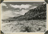 |
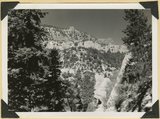
Hurricane Cliffs looking north across mouth of Swayne Creek. Iron County | P0013 Herbert E. Gregory Photograph Collection | P0013n11_170_2795 |
| 66 |
 |
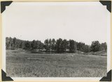
Sidney Valley near head of Castle Creek. Ponds and kame-like accumulation resulting from glaciation. Iron County, UT | P0013 Herbert E. Gregory Photograph Collection | P0013n11_171_2796 |
| 67 |
 |
Sidney Valley near head of Castle Creek. Ponds and kame-like accumulation resulting from glaciation. Iron County, UT | P0013 Herbert E. Gregory Photograph Collection | P0013n11_171_2797 |
| 68 |
 |
Surface of Kolob Terrace near head of Crystal Creek. Developed on Tropic shale | P0013 Herbert E. Gregory Photograph Collection | P0013n11_172_2798 |
| 69 |
 |
Panorama. Surface of Kolob Terrace near the head of Kolob Creek. Iron County, UT | P0013 Herbert E. Gregory Photograph Collection | P0013n11_172_2799 |
| 70 |
 |
Panorama. Surface of Kolob Terrace near the head of Kolob Creek. Iron County, UT | P0013 Herbert E. Gregory Photograph Collection | P0013n11_173_2800 |
| 71 |
 |
View looking north from near head of South Creek across Coal Canyon, Iron County, UT | P0013 Herbert E. Gregory Photograph Collection | P0013n11_173_2801 |
| 72 |
 |
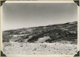
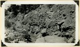
Log Hollow fault (Cretaceous), Kaiparowits formation, on upthrown side (middle and right) in contact with Tertiary (left). Estimated displacement 700 feet. Bowery Canyon, Iron County, UT. 1942 | P0013 Herbert E. Gregory Photograph Collection | P0013n11_174_2802 |
| 73 |
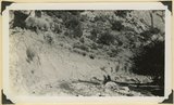 |
Recent trenching of valley fill of stratified sands and clay, upper part of Spring Creek Canyon, Iron County, UT, 1942 | P0013 Herbert E. Gregory Photograph Collection | P0013n11_174_2803 |
| 74 |
 |
Recent trenching of valley fill of stratified sands and clay, upper part of Spring Creek Canyon, Iron County, UT, 1942 | P0013 Herbert E. Gregory Photograph Collection | P0013n11_175_2804 |
| 75 |
 |
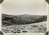
Surface of the Piute Highlands looking north from Mithcell Ridge, Iron County, UT, 1942 | P0013 Herbert E. Gregory Photograph Collection | P0013n11_175_2805 |