|
|
Title | Collection Number And Name | Photo Number |
| 26 |
 |
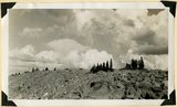
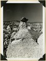
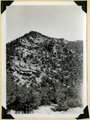
Top of Brian Head (11,280 feet) showing fracture of rhyolite by frost. Iron County, UT. 1941 | P0013 Herbert E. Gregory Photograph Collection | P0013n11_154_2763 |
| 27 |
 |
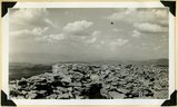
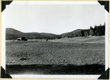
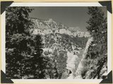
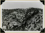
Top of ridge near head of Lauder Valley showing frost work and vegetation on Markagunt Plateau at altitudes between 10,000 and 11,000 feet. Iron County, UT, 1941 | P0013 Herbert E. Gregory Photograph Collection | P0013n11_154_2764 |
| 28 |
 |
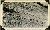
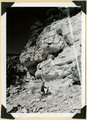
Volcanic Conglomerate at the base of a succession of lavas on the cliff face of Brian Head. Iron County, UT. 1941 | P0013 Herbert E. Gregory Photograph Collection | P0013n11_155_2765 |
| 29 |
 |
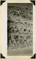
Kaiparowits formation, head of Deep Creek, Iron County, UT. 1941 | P0013 Herbert E. Gregory Photograph Collection | P0013n11_155_2766 |
| 30 |
 |
Kaiparowits formation near southwest corner of Cedar Breaks National Monument. Iron County, UT. 1941 | P0013 Herbert E. Gregory Photograph Collection | P0013n11_156_2767 |
| 31 |
 |
Kaiparowits formation on Cedar City, Cedar Breaks road above Wood's Ranch. Iron County, UT. 1941 | P0013 Herbert E. Gregory Photograph Collection | P0013n11_156_2768 |
| 32 |
 |
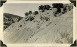
Glacial till, Castle Creek below Sidney Valley. Top of Markagunt Plateau. Iron County, UT. 1941 | P0013 Herbert E. Gregory Photograph Collection | P0013n11_157_2769 |
| 33 |
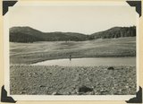 |
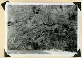
Sidney Valley. Ponds and mounds produced by glaciation. Iron County | P0013 Herbert E. Gregory Photograph Collection | P0013n11_157_2770 |
| 34 |
 |
Sidney Valley. Ponds and mounds produced by glaciation. Iron County | P0013 Herbert E. Gregory Photograph Collection | P0013n11_158_2771 |
| 35 |
 |
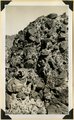
Talus of blocks from basalt sheet. Square Mountain. Iron County, UT. 1941 | P0013 Herbert E. Gregory Photograph Collection | P0013n11_158_2772 |
| 36 |
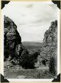 |
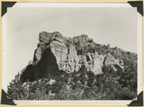
Mouth of Camp Creek. Resistant limestones of lowest Triassic make walls. Iron County, UT. 1941 | P0013 Herbert E. Gregory Photograph Collection | P0013n11_159_2773 |
| 37 |
 |
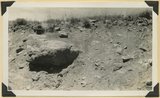
Contact of Triassic and Permian (beds in wall wrinkled at base). Cherty limestone lower left. Camp Creek. Iron County, UT. 1941 | P0013 Herbert E. Gregory Photograph Collection | P0013n11_159_2774 |
| 38 |
 |
Surface of Kolob Terrace looking southeast near Pryor Knoll, Iron County, UT. 1941 | P0013 Herbert E. Gregory Photograph Collection | P0013n11_160_2776 |
| 39 |
 |
Same as 2776. Looking northeast to edge of Markagunt Plateau | P0013 Herbert E. Gregory Photograph Collection | P0013n11_161_2777 |
| 40 |
 |
Same as 2776. Looking north across Coal Creek Canyon. Sugar Loaf on middle skyline | P0013 Herbert E. Gregory Photograph Collection | P0013n11_161_2778 |
| 41 |
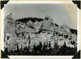 |
Kaiparowits formation Cretaceous. Conglomerate (pinnacles) in contact with bedded arkosie sandstone. Parowan Canyon. Iron Co | P0013 Herbert E. Gregory Photograph Collection | P0013n11_162_2779 |
| 42 |
 |
Same as 2779. Detail contact of conglomerate (foreground) and rough bedded, carbonaceous sandstone above | P0013 Herbert E. Gregory Photograph Collection | P0013n11_163_2780 |
| 43 |
 |
Same as 2779. Detail contact of conglomerate (foreground) and rough bedded, carbonaceous sandstone above | P0013 Herbert E. Gregory Photograph Collection | P0013n11_163_2781 |
| 44 |
 |
Same as 2779. Detail contact of conglomerate (foreground) and rough bedded, carbonaceous sandstone above | P0013 Herbert E. Gregory Photograph Collection | P0013n11_164_2782 |
| 45 |
 |
Kaiparowits formation unconformable below Wasatch limestone south, foot of Parowan Canyon, Iron County, UT. 1941 | P0013 Herbert E. Gregory Photograph Collection | P0013n11_164_2783 |
| 46 |
 |
Undifferentiated Cretaceous formation near mouth of Parowan Canyon. Iron County, UT | P0013 Herbert E. Gregory Photograph Collection | P0013n11_165_2784 |
| 47 |
 |
Undifferentiated Cretaceous formation near mouth of Parowan Canyon. Iron County, UT | P0013 Herbert E. Gregory Photograph Collection | P0013n11_165_2785 |
| 48 |
 |
Fault, Wasatch limestone (extreme right) in horizontal contact with undifferentiated Cretaceous. Parowan Canyon. Iron County, UT | P0013 Herbert E. Gregory Photograph Collection | P0013n11_166_2786 |
| 49 |
 |
Fault, Wasatch limestone (extreme right) in horizontal contact with undifferentiated Cretaceous. Parowan Canyon. Iron County, UT | P0013 Herbert E. Gregory Photograph Collection | P0013n11_166_2787 |
| 50 |
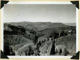 |
Summit Ridge. View looking south across Braffitts Canyon. Iron County, UT | P0013 Herbert E. Gregory Photograph Collection | P0013n11_167_2788 |