|
|
Title | Collection Number And Name | Photo Number |
| 1 |
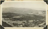 |
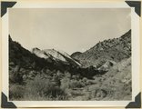
View southwest from Brian Head, showing head of Cedar Canyon, the northern Kolob Plateau, and Pine Valley Mountains (in distance). Iron County, Utah, 1937. | P0013 Herbert E. Gregory Photograph Collection | P0013n10_207_2462 |
| 2 |
 |
View north along the rim of Markagunt Plateau from Brian Head. Iron County, Utah, 1937. | P0013 Herbert E. Gregory Photograph Collection | P0013n10_208_2463 |
| 3 |
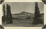 |
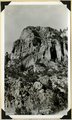
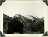
Brian Head, volcanic mass from the north rim of Cedar Breaks, Iron County, Utah, 1937. | P0013 Herbert E. Gregory Photograph Collection | P0013n10_208_2464 |
| 4 |
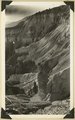 |
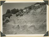
Rim of canyon at Cedar Breaks, Wasatch formation, Iron County, Utah, 1937. | P0013 Herbert E. Gregory Photograph Collection | P0013n10_209_2465 |
| 5 |
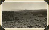 |
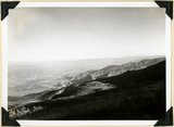
View southeast from top of Brian Head. Hancock Peak in center middle distance; Paunsaugunt Plateau on left horizon. Iron County, Utah, 1936. | P0013 Herbert E. Gregory Photograph Collection | P0013n10_209_2466 |
| 6 |
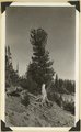 |
Roots of limber pine exposed by erosion, north rim of Cedar Breaks. Iron County, Utah, 1936. | P0013 Herbert E. Gregory Photograph Collection | P0013n10_210_2467 |
| 7 |
 |
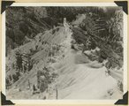
Near west edge of Kolob Terrace, looking northeast across mouth of Coal Creek; tilted rocks at Hurricane fault (middle); Cedar City, lower left. Iron County, UT | P0013 Herbert E. Gregory Photograph Collection | P0013n11_011_2544 |
| 8 |
 |
North Rim of canyon, Wasatch limestone. Iron Mountain in distance west. Cedar Breaks National Monument | P0013 Herbert E. Gregory Photograph Collection | P0013n11_031_2574 |
| 9 |
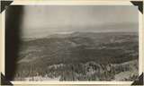 |
Panorama northwest of Brian Head, Markagunt Plateau. Glacial topography foreground; Wasatch formation (middle distance); Little Salt Lake in valley beyond Hurricane Cliffs. Iron County, UT | P0013 Herbert E. Gregory Photograph Collection | P0013n11_031_2575 |
| 10 |
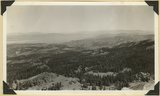 |
Panorama northwest of Brian Head, Markagunt Plateau. Glacial topography foreground; Wasatch formation (middle distance); Little Salt Lake in valley beyond Hurricane Cliffs. Iron County, UT | P0013 Herbert E. Gregory Photograph Collection | P0013n11_032_2576 |
| 11 |
 |
Lava cap on Straight Cliffs formation foot of dugway in Cedar Canyon. Iron County, UT | P0013 Herbert E. Gregory Photograph Collection | P0013n11_033_2577 |
| 12 |
 |
Fault on Rim Point Wasatch formation. Cedar Break National Monument | P0013 Herbert E. Gregory Photograph Collection | P0013n11_033_2578 |
| 13 |
 |
Spur on wall of canyon. Wasatch limestone. Cedar Breaks National Monument | P0013 Herbert E. Gregory Photograph Collection | P0013n11_034_2579 |
| 14 |
 |
Fossiliferous Straight Cliffs sandstone, Kolob Terrace, Washington County, UT, 1939 | P0013 Herbert E. Gregory Photograph Collection | P0013n11_050_2607 |
| 15 |
 |
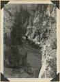
Spring Creek. From open valley (foreground) on Carmel limestone passes into canyon in Navajo sandstone that in part forms Hurricane Cliffs. Typical stream on western Kolob Terrace, Washington County, UT, 1939 | P0013 Herbert E. Gregory Photograph Collection | P0013n11_054_2615 |
| 16 |
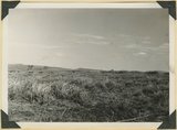 |
Surface of Kolob Terrace. Divide between North Creek and Kolob Creek, Washington County, UT. 1939 | P0013 Herbert E. Gregory Photograph Collection | P0013n11_056_2618 |
| 17 |
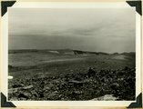 |
Surface of Kolob Terrace showing sharp drop to heads of deep canyons. Lava in foreground, Washington County, UT. 1939 | P0013 Herbert E. Gregory Photograph Collection | P0013n11_057_2619 |
| 18 |
 |
Shnabkaib member of the Moenkopi formation upturned in a fold which involves upper red beds (right), Coal Canyon. Iron County, UT. 1940 | P0013 Herbert E. Gregory Photograph Collection | P0013n11_135_2728 |
| 19 |
 |
Shnabkaib member of the Moenkopi formation upturned in a fold which involves upper red beds (right), Coal Canyon. Iron County, UT. 1940 | P0013 Herbert E. Gregory Photograph Collection | P0013n11_136_2729 |
| 20 |
 |
Winsor formation, two miles northeast of Horseranch Point, Zion National Monument. Iron County, UT, 1940 | P0013 Herbert E. Gregory Photograph Collection | P0013n11_137_2730 |
| 21 |
 |
General view of eroded Pink Cliffs (Wasatch formation) near Cedar Breaks, Iron County, UT | P0013 Herbert E. Gregory Photograph Collection | P0013n11_151_2757 |
| 22 |
 |
Panorama of Ashdown Canyon, 600-1800 feet deep, 20-150 feet wide out in Straight Cliffs sandstone. Iron County, UT, 1941 | P0013 Herbert E. Gregory Photograph Collection | P0013n11_152_2759 |
| 23 |
 |
Panorama of Ashdown Canyon, 600-1800 feet deep, 20-150 feet wide out in Straight Cliffs sandstone. Iron County, UT, 1941 | P0013 Herbert E. Gregory Photograph Collection | P0013n11_152_2760 |
| 24 |
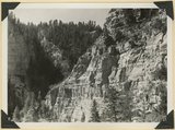 |
Straight Cliffs sandstone (Cretaceous) Wall of Ashdown Canyon, Iron County, UT. 1941 | P0013 Herbert E. Gregory Photograph Collection | P0013n11_152_2761 |
| 25 |
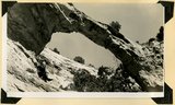 |
Natural bridge near top of wall of Ashdown Canyon, Iron County, UT, 1941 | P0013 Herbert E. Gregory Photograph Collection | P0013n11_153_2762 |