|
|
Title | Collection Number And Name | Photo Number |
| 26 |
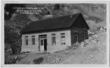 |
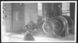
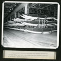
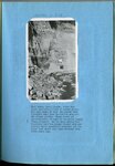
Davis County Station, Farmington, Utah [1] | P0206 Rocky Mountain Power Company Photograph Collection | P0206add2n03_06_002.tif |
| 27 |
 |
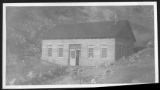
Davis County Station, Farmington, Utah [3] | P0206 Rocky Mountain Power Company Photograph Collection | P0206add2n03_06_003.tif |
| 28 |
 |
Davis County Station, Farmington, Utah [2] | P0206 Rocky Mountain Power Company Photograph Collection | P0206add2n03_06_004.tif |
| 29 |
 |
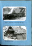
Davis County Light and Power Supply plant, Farmington, Utah [1] | P0206 Rocky Mountain Power Company Photograph Collection | P0206add2n33_114 |
| 30 |
 |
Davis County Light and Power Supply plant, Farmington, Utah [2] | P0206 Rocky Mountain Power Company Photograph Collection | P0206add2n33_115 |
| 31 |
 |
Davis County Light and Power Supply plant, Farmington, Utah [3] | P0206 Rocky Mountain Power Company Photograph Collection | P0206add2n33_116 |
| 32 |
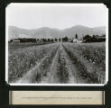 |
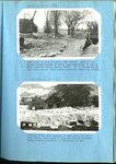
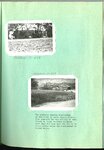
Onion seed field, Davis County, Utah | P0206 Rocky Mountain Power Company Photograph Collection | P0206add2n35_031 |
| 33 |
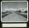 |
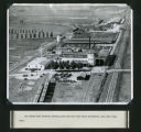
Clearfield Naval Supply Depot, Davis County, Utah [1] | P0206 Rocky Mountain Power Company Photograph Collection | P0206add2n35_040 |
| 34 |
 |
Clearfield Naval Supply Depot, Davis County, Utah [2] | P0206 Rocky Mountain Power Company Photograph Collection | P0206add2n35_041 |
| 35 |
 |
Clearfield Naval Supply Depot, Davis County, Utah [3] | P0206 Rocky Mountain Power Company Photograph Collection | P0206add2n35_042 |
| 36 |
|
Clearfield Naval Supply Depot, Davis County, Utah [4] | P0206 Rocky Mountain Power Company Photograph Collection | P0206add2n35_042 |
| 37 |
 |
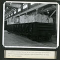
Cudahy Packing Company plant and stockyards, NorthSalt Lake, Davis County, Utah | P0206 Rocky Mountain Power Company Photograph Collection | P0206add2n36_015 |
| 38 |
 |
Erosion, North Salt Lake 1932 [and] Erosion west of Salt Lake, on north point of Oquirrh Mountains | P0208 Utah Flood Survey photograph collection | P0208n01_01_001-002 |
| 39 |
 |
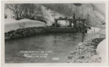
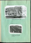
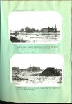
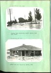
Farmington floods : Farmington flood barrier in its early stages of development [and] The same successfully controlling a heavy torrential flood on July 3, 1925 | P0208 Utah Flood Survey photograph collection | P0208n01_01_025-026 |
| 40 |
 |
Farmington floods : Farmington spillway following a torrential flood [ad] Debris deposited above the Farmington barrier by the flood of July 3, 1926 | P0208 Utah Flood Survey photograph collection | P0208n01_01_027-028 |
| 41 |
 |
Farmington floods : Farmington spillway of rubble-concrete during the first season of operation, April 1925 [and] The same in 1927 | P0208 Utah Flood Survey photograph collection | P0208n01_01_029-030 |
| 42 |
 |
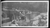
Farmington floods : Farmington flood barrier at the close of a season of excessive high water [and] Looking up stream from spillway into Farmington barrier basin | P0208 Utah Flood Survey photograph collection | P0208n01_01_031-032 |
| 43 |
 |
Ford Creek floods : Ford Creek, Davis County, after the third torrential flood in recent years | P0208 Utah Flood Survey photograph collection | P0208n01_01_033 |
| 44 |
 |
Ford Creek floods : Result of and flow from torrential flood, Ford Creek, August 13, 1923 [and] The disaster of 1923 repeated on Ford Creek in a series of three floods in 1930 | P0208 Utah Flood Survey photograph collection | P0208n01_01_034-035 |
| 45 |
 |
Ford Creek floods : Ford Creek in 1924 following 1923 floods [and] Looking across state highway at Ford Creek following 1930 flood | P0208 Utah Flood Survey photograph collection | P0208n01_01_036-037 |
| 46 |
 |
Parrish Creek and Centerville flooding : Parrish Creek showing Centerville school in the midst of an area devastated by the floods of 1930 [and] Remnants of a home on Parrish Creek near the Centerville school, September 1930 | P0208 Utah Flood Survey photograph collection | P0208n01_01_038-039 |
| 47 |
 |
Parrish Creek and Centerville flooding : Highway below Centerville School, Parrish Creek 1930 floods [and] Another home near Centerville School 1930 | P0208 Utah Flood Survey photograph collection | P0208n01_01_040-041 |
| 48 |
 |
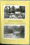
Parrish Creek and Centerville flooding : Two pictures showing consistency of mud flows in Davis County floods | P0208 Utah Flood Survey photograph collection | P0208n01_01_042-043 |
| 49 |
 |
Digging the state highway out after a typical Davis County flood [and] A minor flood from Steed Creek blocked the highway as indicated | P0208 Utah Flood Survey photograph collection | P0208n01_01_044-045 |
| 50 |
 |
Highway fo Steed Creek crossing during torrential flood, looking upstream [and] A woven wire fence parallel to direction of flow held a torrential flood within bounds, just above highway crossing at Fiddler's Creek near Cedar City | P0208 Utah Flood Survey photograph collection | P0208n01_01_046-047 |