Home
Browse
Ask Us
Chat
Harmful Language Statement
Log in
American Westward Migration
Advanced Search
About
Diaries, maps and trails of Mormon pioneers and their westward migration in the 1850s. Diaries include Joseph C. Kingsbury, George A. Thomas, John B. Fairbanks, Joseph A. Young, and Lucia Lamb Everett.
Year
1845
1846
1847
1848
1849
1850
1851
1852
1853
1854
1855
1856
1857
1858
1859
1860
1861
1862
1863
1864
TO
1845
1846
1847
1848
1849
1850
1851
1852
1853
1854
1855
1856
1857
1858
1859
1860
1861
1862
1863
1864
Type
Image/StillImage
34
Image
2
Format
image/jpeg
36
Collection
American Westward Migration
36
Filters:
Format:
"image/jpeg"
Collection:
"uu_awm"
Year End:
2016
26
-
50
of
36
<
1
2
>
Gallery view
Number of results to display per page
10
25
50
100
200
Sort by Relevance
Sort by Title A-Z
Sort by Title Z-A
Sort by Date Ascending
Sort by Date Descending
Sort by Last Modified Ascending
Sort by Last Modified Descending
Title
Date
Type
26
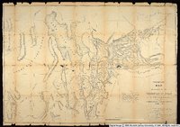
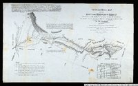
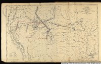
Preliminary map of routes reconnoitered and opened in the Territory of Utah by Capt. J. H. Simpson, Corps of Topographical Engineers, in the fall of 1858, under the orders of Bvt. Brigadier General A.S. Johnston, commanding the Department of Utah.
1858
Image/StillImage
27
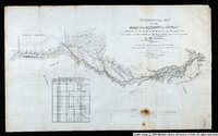
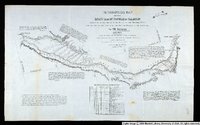
Sketch of the country between South Pass and the Great Salt Lake.
1857
Image/StillImage
28
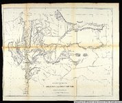
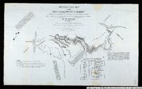
Territories of New Mexico and Utah.
1855
Image/StillImage
29
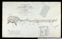
Topographical Map of the Road From Missouri To Oregon Commencing at the Mouth of the Kansas in the Missouri River and Ending at the Mouth of the Wallah-Wallah in the Columbia. Section 1
1846
Image/StillImage
30
Topographical Map of the Road From Missouri To Oregon Commencing at the Mouth of the Kansas in the Missouri River and Ending at the Mouth of the Wallah-Wallah in the Columbia. Section 2
1846
Image/StillImage
31
Topographical Map of the Road From Missouri To Oregon Commencing at the Mouth of the Kansas in the Missouri River and Ending at the Mouth of the Wallah-Wallah in the Columbia. Section 3
1846
Image/StillImage
32
Topographical Map of the Road From Missouri To Oregon Commencing at the Mouth of the Kansas in the Missouri River and Ending at the Mouth of the Wallah-Wallah in the Columbia. Section 4
1846
Image/StillImage
33
Topographical Map of the Road From Missouri To Oregon Commencing at the Mouth of the Kansas in the Missouri River and Ending at the Mouth of the Wallah-Wallah in the Columbia. Section 5
1846
Image/StillImage
34
Topographical Map of the Road From Missouri To Oregon Commencing at the Mouth of the Kansas in the Missouri River and Ending at the Mouth of the Wallah-Wallah in the Columbia. Section 6
1846
Image/StillImage
35
Topographical Map of the Road From Missouri To Oregon Commencing at the Mouth of the Kansas in the Missouri River and Ending at the Mouth of the Wallah-Wallah in the Columbia. Section 7
1846
Image/StillImage
36
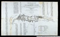
Utah and the Overland Routes to it from the Missouri River
1855
Image/StillImage
26
-
50
of
36
<
1
2
>