Home
Browse
Ask Us
Chat
Harmful Language Statement
Log in
Uintah County Regional History Center Maps
Advanced Search
Year
1878
1879
1880
1881
1882
1883
1884
1885
1886
1887
1888
1889
1890
1891
1892
1893
1894
1895
1896
1897
1898
1899
1900
1901
1902
1903
1904
1905
1906
1907
1908
1909
1910
1911
1912
1913
1914
1915
1916
1917
1918
1919
1920
1921
1922
1923
1924
1925
1926
1927
1928
1929
1930
1931
1932
1933
1934
1935
1936
1937
1938
1939
1940
1941
1942
1943
1944
1945
1946
1947
1948
1949
1950
1951
1952
1953
1954
1955
1956
1957
1958
1959
1960
1961
1962
1963
1964
1965
1966
1967
1968
1969
1970
1971
1972
1973
1974
1975
1976
1977
1978
1979
1980
1981
1982
1983
1984
1985
1986
1987
1988
1989
1990
1991
1992
1993
1994
1995
1996
1997
1998
1999
2000
2001
2002
2003
2004
2005
2006
2007
2008
2009
2010
2011
2012
2013
2014
TO
1878
1879
1880
1881
1882
1883
1884
1885
1886
1887
1888
1889
1890
1891
1892
1893
1894
1895
1896
1897
1898
1899
1900
1901
1902
1903
1904
1905
1906
1907
1908
1909
1910
1911
1912
1913
1914
1915
1916
1917
1918
1919
1920
1921
1922
1923
1924
1925
1926
1927
1928
1929
1930
1931
1932
1933
1934
1935
1936
1937
1938
1939
1940
1941
1942
1943
1944
1945
1946
1947
1948
1949
1950
1951
1952
1953
1954
1955
1956
1957
1958
1959
1960
1961
1962
1963
1964
1965
1966
1967
1968
1969
1970
1971
1972
1973
1974
1975
1976
1977
1978
1979
1980
1981
1982
1983
1984
1985
1986
1987
1988
1989
1990
1991
1992
1993
1994
1995
1996
1997
1998
1999
2000
2001
2002
2003
2004
2005
2006
2007
2008
2009
2010
2011
2012
2013
2014
Type
Image/StillImage
300
Format
image/jpeg
300
Collection
Uintah County Regional History Center...
300
Filters:
Format:
"image/jpeg"
Collection:
"ucl_maps"
Subject:
"Utah"
Format:
image
Setname:
!(ir* OR ehsl*)
51
-
75
of
300
<
1
2
3
4
5
6
7
8
9
10
>
Gallery view
Number of results to display per page
10
25
50
100
200
Sort by Relevance
Sort by Title A-Z
Sort by Title Z-A
Sort by Date Ascending
Sort by Date Descending
Sort by Last Modified Ascending
Sort by Last Modified Descending
Title
Date
Type
51
Dinosaurland Bike Routes
Image/StillImage
52
Dinosaurland Eastern Uintas Cross-Country Ski Trails
Image/StillImage
53
Dinosaurland One-Day Self-Guided Tour #10 North Fork of the Duchesne River
Image/StillImage
54
Dinosaurland One-Day Self-Guided Tour #11 Rock Creek and Upper Stillwater Dam
Image/StillImage
55
Dinosaurland One-Day Self-Guided Tour #2 Indian Petroglyphs Dry Fork Canyon
Image/StillImage
56
Dinosaurland One-Day Self-Guided Tour #3 Red Cloud Loop Scenic Byway
Image/StillImage
57
Dinosaurland One-Day Self-Guided Tour #4 Red Fleet & Steinaker Lake State Parks
Image/StillImage
58
Dinosaurland One-Day Self-Guided Tour #5 Dinosaur National Monument, Quarry and Harper's Corner
Image/StillImage
59
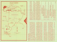
Dinosaurland One-Day Self-Guided Tour #6 Outlaw Country - Crouse Canyon, Brown's Park, Javie's Ranch, Jessie Ewing Canyon
Image/StillImage
60
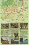
Dinosaurland One-Day Self-Guided Tour #7 Vernal Walking Tour
Image/StillImage
61
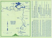
Dinosaurland One-Day Self-Guided Tour #8 Sheep Creek Canyon and Spirit Lake
Image/StillImage
62
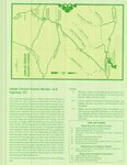
Dinosaurland One-Day Self-Guided Tour #9 Indian Canyon
Image/StillImage
63
Dixie US DOI BLM 1977
1977
Image/StillImage
64
Dominguez - Escalante Expedition 1776 (Brochure and Map)
Image/StillImage
65
Duchesne County Road Map
2004
Image/StillImage
66
Duchesne County Tourism Map
Image/StillImage
67
Duchesne US DOI BLM 1977
1977
Image/StillImage
68
Dutch John, Utah 1997
1997
Image/StillImage
69
Dutch John, Utah-Colorado-Wyoming 1981
1981
Image/StillImage
70
Dutch John, Utah-Colorado-Wyoming 1982
1981; 1982
Image/StillImage
71
Fish Lake US DOI BLM 1978
1978
Image/StillImage
72
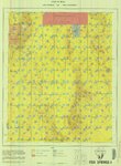
Fish Springs US DOI BLM 1977
1977
Image/StillImage
73
Flaming Gorge Country (Brochure and Map)
1987
Image/StillImage
74
Flaming Gorge National Recreation Area
1987
Image/StillImage
75
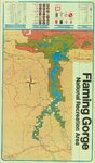
Flaming Gorge National Recreation Area - Ashley National Forest
Image/StillImage
51
-
75
of
300
<
1
2
3
4
5
6
7
8
9
10
>