TO
1 - 25 of 6
| Author | Title | Subject | Date | Publication Type | ||
|---|---|---|---|---|---|---|
| 1 |
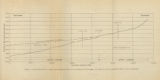 |
Gates, Joseph S. | Figure 4: Longitudinal profile of Middle Canyon showing locations of the profiles across the canyon, the nickpoint, and the hypothetical profile before rejuvenation | Thesis and dissertation georeferencing project | 1960-08 | thesis |
| 2 |
 |
Arnold, Steven | MSGIS Portfolio | 2016-12 | online portfolio | |
| 3 |
 |
Brox, George Stanley | Plate 1: Geologic map of Northern Bryce Canyon National Park | 1961-06 | thesis | |
| 4 |
 |
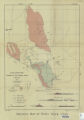
Earll, Fred Nelson | Plate1-part1 Geologic map of the Central Mineral Range, Beaver County, Utah | Geology -- Utah -- Mineral Mountains; Geology -- Utah -- Beaver County | 1957-08 | thesis |
| 5 |
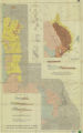 |
Plate17 Geologic map and sections of parts of the Magna, Lark, Fairfield, and Jordan Narrows quadrangles, Utah | Magna - Utah; Lark- Utah; Fairfield - Utah; Jordan Narrows - Utah; Geological map | 1955 | map | |
| 6 |
 |
Slentz, L. W. | Plate18 Geologic map of Rozel Hills, Utah | Geology - Rozel Hills. Utah; Geology map | 1955-06 | map |
1 - 25 of 6