Home
Browse
Ask Us
Chat
Harmful Language Statement
Log in
Advanced Search
Year
1867
1868
1869
1870
1871
1872
1873
1874
1875
1876
1877
1878
1879
1880
1881
1882
1883
1884
1885
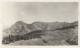
1886
1887
1888
1889
1890
1891
1892
1893
1894
1895
1896
1897
1898
1899
1900
1901
1902
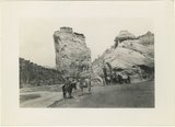
1903
1904
1905
1906
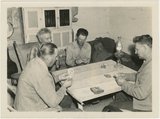
1907
1908
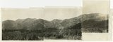
1909
1910
1911
1912
1913
1914
1915
1916
1917
1918
1919
1920
1921
1922
1923
1924
1925
1926
1927
1928
1929
1930
1931
1932
1933
1934
1935
1936
1937
1938
1939
1940
1941
1942
1943
1944
1945
1946
1947
1948
1949
1950
1951
1952
1953
1954
1955
1956
1957
1958
1959
1960
1961
1962
1963
1964
1965
1966
1967
1968
1969
1970
1971
1972
1973
1974
1975
1976
1977
1978
1979
1980
1981
1982
1983
1984
1985
1986
1987
1988
1989
1990
1991
1992
1993
1994
1995
1996
1997
1998
1999
2000
2001
2002
2003
2004
2005
2006
2007
2008
2009
2010
2011
2012
2013
2014
2015
2016
2017
2018
2019
2020
2021
2022
2023
2024
TO
1867
1868
1869
1870
1871
1872
1873
1874
1875
1876
1877
1878
1879
1880
1881
1882
1883
1884
1885
1886
1887
1888
1889
1890
1891
1892
1893
1894
1895
1896
1897
1898
1899
1900
1901
1902
1903
1904
1905
1906
1907
1908
1909
1910
1911
1912
1913
1914
1915
1916
1917
1918
1919
1920
1921
1922
1923
1924
1925
1926
1927
1928
1929
1930
1931
1932
1933
1934
1935
1936
1937
1938
1939
1940
1941
1942
1943
1944
1945
1946
1947
1948
1949
1950
1951
1952
1953
1954
1955
1956
1957
1958
1959
1960
1961
1962
1963
1964
1965
1966
1967
1968
1969
1970
1971
1972
1973
1974
1975
1976
1977
1978
1979
1980
1981
1982
1983
1984
1985
1986
1987
1988
1989
1990
1991
1992
1993
1994
1995
1996
1997
1998
1999
2000
2001
2002
2003
2004
2005
2006
2007
2008
2009
2010
2011
2012
2013
2014
2015
2016
2017
2018
2019
2020
2021
2022
2023
2024
Type
Text
287
Image
70
Sound
5
Format
application/pdf
1,179
Collection
44th Bomb Group - 8 Ball Tails Magazine
1
Alan K Engen Papers
2
American West Center Research Projects
12
Angus Munn Woodbury Papers
1
Athletics
13
Charles James Nabors Papers
3
Civilian Conservation Corps Newslette...
1
College of Law Publications
54
College of Nursing
13
Colorado Riverbed Case
2
Continuum
7
Cycling Utah
1
Electronic University Archive
49
Elias Hicks Blackburn Papers, 1848-1908
2
Everett L. Cooley Oral History Project
15
Glen Canyon
1
Graduate Nursing Project
1
Hinckley Journal of Politics
1
Historic and Prehistoric Publications
133
Honors Theses Closed Archive
1
Honors Theses Open Access
4
Illuminations
2
Intermountain Ski Instructors Associa...
10
Juanita Brooks Papers
3
Kem C. Gardner Policy Institute Colle...
1
Linford and Richards Family Collection
4
Manuscripts
4
Marriner S. Eccles Papers
19
Marriott Digital Publishing Archive
1
Marriott Library Digital Stacks
1
Midvale Museum
1
Mormon Settlement in Arizona
2
NOVEL - Journal of Neuro-Ophthalmology
1
Neighborhood Partners
1
Photo Archives
74
Public Affairs of Health Sciences Center
4
Rare Books Collection
7
Theater Programs Collection, 1866-1995
1
Theses & Dissertations
37
UAIDA Main Collection
1
UMFA Docent Archive
1
UScholar Works
7
University of Utah Board of Regents M...
2
University of Utah Press Open Access ...
5
Uranium Oral Histories
1
Utah City Directories Collection
557
Utah Historic Building Records
60
Utah Historical Society Oral History ...
1
Utah Medical Association Bulletin
13
Utah National Register Nomination Forms
1
Utah Pharmacy Digest
6
Utah State Board Of Regents
6
Utah's Urban Pioneer Folk Music Reviv...
1
Utonian Yearbooks
13
Western Waters AZ. vs CA.
1
Western Waters Documents
4
Western Waters NEH
9
More
Filters:
Format:
"application/pdf"
26
-
50
of
1,179
<
1
2
3
4
5
6
7
8
9
10
>
Gallery view
Number of results to display per page
10
25
50
100
200
Sort by Relevance
Sort by Title A-Z
Sort by Title Z-A
Sort by Date Ascending
Sort by Date Descending
Sort by Last Modified Ascending
Sort by Last Modified Descending
Title
Date
Type
Setname
26
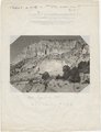
Herbert E. Gregory Book 6: Navajo, 1913
1913
Image
uum_map
27
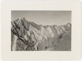
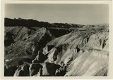
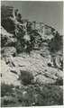
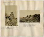
Ridge of uptilted strata
1940
Image
uum_map
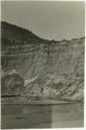
28
Johnson Creek. Old alluvial fill trenched 40 feet since 1915, Kane County, Utah, 1939
1939
Image
uum_map
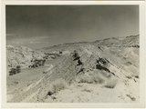
29
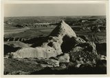
Eroded flank of the East Kaibab monocline at the junction of Paria River and Cottonwood Creek (left center). The sequence is Navajo (left), upper Jurassic (largely eroded), Dakota, Tropic, and Straight Cliffs. Kane County, UT, 1944
1944
Image
uum_map
30
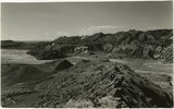
Flat lying Upper Jurassic (foreground) and Cretaceous strata bed abruptly upward against the Navajo on the flank of the East Kaibab monocline (left sky line). Table Cliffs (right sky line) is about 50 miles north. Paria Valley near Adairville. Kane County, UT. 1944
1944
Image
uum_map
31
Herbert E. Gregory Book 10: San Juan, Zion, Capitol Reef, 1915-1938
1915; 1916; 1917; 1918; 1919; 1920; 1921; 1922; 1923; 1924; 1925; 1926; 1927; 1928; 1929; 1930; 1931; 1932; 1933; 1934; 1935; 1936; 1937; 1938
Image
uum_map
32
Looking south, up dip, across West Clark Bench, Upper Jurassic and Dakota (butte), to the Paria Terrace, Navajo sandstone. Paria River, which passes through 'The Gap' is joined by Kaibab Creek. Kane County, UT. 1944
1944
Image
uum_map
33
Panorama {c}. Flank of East Kaibab monocline, bordering alluvial floor of Paria Valley. Navajo sandstone (middle sky line), Upper Jurassic strata, and basal Cretaceous (left). Dips of 40 degrees decrease to 3 degrees within 1,000 feet. Kane County, UT, 1944
1944
Image
uum_map
34
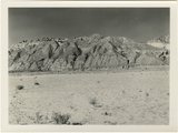
Navajo sandstone, part of White Cliffs, near head of Johnson Canyon, Kane Co., Utah, 1939
1939
Image
uum_map
35
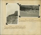
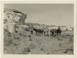
Herbert Gregory party at watering station in Paria Valley, Utah
1943
Image
uum_map
36
Contact of Kayenta formation (foreground) and Navajo sandstone Park Wash above the mouth of Five Pines Wash. Kane County, UT. 1943
1943
Image
uum_map
37
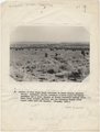
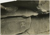
Indian pictographs near Mt. Carmel road.
1930; 1931; 1932; 1933; 1934; 1935; 1936; 1937
Image
uum_map
38
Herbert E. Gregory Book 7: Navajo, 1913, 1914
1913; 1914
Image
uum_map
39
Looking south (up dip) down the Paria River, which has widened its floor and dissected its borders in Upper Jurassic rocks (foreground) and cut a deep narrow canyon in the Navajo sandstone (background). Site of the abandoned Adairville. Kane County UT, 1944
1944
Image
uum_map
40
Looking south along Paria River from the mouth of Shurtz Gorge. Navajo sandstone in East Kaibab monocline is overlaid with decreasing dips by Upper Jurassic (banked against the Navajo), Dakota, and Tropic (foreground and left sky line). Erosion surface (middle distance) bevels upturned rocks. Kane County, UT, 1944
1944
Image
uum_map
41
Herbert E. Gregory Book 8: Arizona, Utah, Nevada, California, 1915-1922
1915; 1918; 1922; 1924
Image
uum_map
42
Paria Canyon, Utah
1943; 1944; 1945
Image
uum_map
43
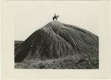
Mound of sedimentary material, vicinity of Paria River, Utah
1943; 1944; 1945
Image
uum_map
44
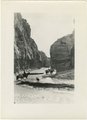
Upper Box in Paria Canyon just south of Cannonville
1943; 1944; 1945
Image
uum_map
45
Herbert E. Gregory Book 9: Utah, California, 1924-1928
1875; 1907; 1921; 1924; 1925; 1927; 1928
Image
uum_map
46
Panorama of head of Johnson Creek, from West Mountain. Abajo Mountains. 1915
1915
Image
uum_map
47
Sandstone outcrops, Paria Canyon, Utah
1943; 1944; 1945
Image
uum_map
48
Card players, Paria Valley camp, 1943
1943
Image
uum_map
49
Traveling with pack mules in Navajo territory [1]
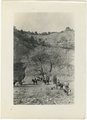
1910
uum_map
50
Panorama, looking west from Camp Jackson. West Peak in left center. Abajo Mountains. Utah, San Juan, 1915.
1915
Image
uum_map
26
-
50
of
1,179
<
1
2
3
4
5
6
7
8
9
10
>