Home
Browse
Ask Us
Chat
Harmful Language Statement
Log in
Advanced Search
Year
1893
1894
1895
1896
1897
1898
1899
1900
1901
1902
1903
1904
1905
1906
1907
1908
1909
1910
1911
1912
1913
1914
1915
1916
1917
1918
1919
1920
1921
1922
1923
1924
1925
1926
1927
1928
1929
1930
1931
1932
1933
1934
1935
1936
1937
1938
1939
1940
1941
1942
1943
1944
1945
1946
1947
1948
1949
1950
1951
1952
1953
1954
1955
1956
1957
1958
1959
1960
1961
1962
1963
1964
1965
1966
1967
1968
1969
1970
1971
1972
1973
1974
1975
1976
1977
1978
1979
1980
1981
1982
1983
1984
1985
1986
1987
1988
1989
1990
1991
1992
1993
1994
1995
1996
1997
1998
1999
2000
2001
2002
2003
2004
2005
2006
2007
2008
2009
2010
2011
2012
2013
2014
2015
2016
2017
2018
TO
1893
1894
1895
1896
1897
1898
1899
1900
1901
1902
1903
1904
1905
1906
1907
1908
1909
1910
1911
1912
1913
1914
1915
1916
1917
1918
1919
1920
1921
1922
1923
1924
1925
1926
1927
1928
1929
1930
1931
1932
1933
1934
1935
1936
1937
1938
1939
1940
1941
1942
1943
1944
1945
1946
1947
1948
1949
1950
1951
1952
1953
1954
1955
1956
1957
1958
1959
1960
1961
1962
1963
1964
1965
1966
1967
1968
1969
1970
1971
1972
1973
1974
1975
1976
1977
1978
1979
1980
1981
1982
1983
1984
1985
1986
1987
1988
1989
1990
1991
1992
1993
1994
1995
1996
1997
1998
1999
2000
2001
2002
2003
2004
2005
2006
2007
2008
2009
2010
2011
2012
2013
2014
2015
2016
2017
2018
Type
Image
22
Text
7
Format
application/pdf
22
Collection
Civilian Conservation Corps
13
Photo Archives
2
Rare Books Collection
2
Theses & Dissertations
3
Westminster College Institutional Rep...
2
Filters:
Format:
"application/pdf"
Type:
"Image"
1
-
25
of
22
Gallery view
Number of results to display per page
10
25
50
100
200
Sort by Relevance
Sort by Title A-Z
Sort by Title Z-A
Sort by Date Ascending
Sort by Date Descending
Sort by Last Modified Ascending
Sort by Last Modified Descending
Title
Date
Type
Setname
1
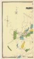
Gorlinski's general map of Park City and Alta mines, compiled from official surveys in Uintah, Blue Ledge, Snake Creek, Big & Little Cottonwood & American Fork Mining districts, Utah
1902
Image
uum_rbc
2
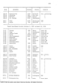
Page 373, B. Camps In Utah, Periods Two Through Eighteen
Image
dha_ccc
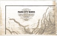
3
Gorlinski's general map of Park City mines
1893
Image
uum_rbc
4
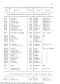
Page 372, B. Camps In Utah, Periods Two Through Eighteen
Image
dha_ccc
5
Page 131, The Camps: 1933-1942
Image
dha_ccc
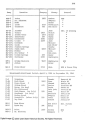
6
Page 370, B. Camps In Utah, Periods Two Through Eighteen
Image
dha_ccc
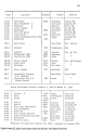
7
Page 371, B. Camps In Utah, Periods Two Through Eighteen
Image
dha_ccc
8
Page 374, B. Camps In Utah, Periods Two Through Eighteen
Image
dha_ccc
9
Page 376, B. Camps In Utah, Periods Two Through Eighteen
Image
dha_ccc
10
Page 366, B. Camps In Utah, Periods Two Through Eighteen
Image
dha_ccc
11
Page 377, B. Camps In Utah, Periods Two Through Eighteen
Image
dha_ccc
12
Page 367, B. Camps In Utah, Periods Two Through Eighteen
Image
dha_ccc
13
Page 375, B. Camps In Utah, Periods Two Through Eighteen
Image
dha_ccc
14
Page 264, Education in the Camps
Image
dha_ccc
15
Page 113, The Camps: 1933-1942
Image
dha_ccc
16
It's Not Just About Us: Understanding the Importance of the Wasatch Mountains, Canyons, and Foothills for the Local Environment
2018-05
Text; Image
wc_ir
17
The Alpenbock Scrapbook, Volume II
1961; 1962; 1963; 1964; 1965; 1966; 1967
Image; Text
uum_map
18
The Alpenbock Scrapbook, Volume I
1960; 1961; 1962; 1963
Image; Text
uum_map
19
Geology of the Terrace and Hogup Mountains, Box Elder County, Utah
1964-06
Text; Image
ir_etd
20
Geology of the West Tintic mining district and vicinity, Juab County, Utah
1954-06
Text; Image
ir_etd
21
The Jordan River Corridor: A Case for Stewardship
2016-04
Text; Image
wc_ir
22
Geology and ground-water resources of Ogden Valley, Utah
1972-06
Text; Image
ir_etd
1
-
25
of
22