Home
Browse
Ask Us
Chat
Harmful Language Statement
Log in
Advanced Search
Year
1849
1850
1851
1852
1853
1854
1855
1856
1857
1858
1859
1860
1861
1862
1863
1864
1865
1866
1867
1868
1869
1870
1871
1872
1873
1874
1875
1876
1877
1878
1879
1880
1881
1882
1883
1884
1885
1886
1887
1888
1889
1890
1891
1892
1893
1894
1895
1896
1897
1898
1899
1900
1901
1902
1903
1904
1905
1906
1907
1908
1909
1910
1911
1912
1913
1914
1915
1916
1917
1918
1919
1920
1921
1922
1923
1924
1925
1926
1927
1928
1929
1930
1931
1932
1933
1934
1935
1936
1937
1938
1939
1940
1941
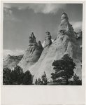
1942
1943
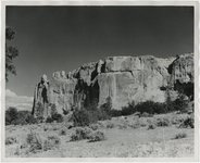
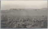
1944
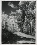
1945
1946
1947
1948
1949
1950
1951
1952
1953
1954
1955
1956
1957
1958
1959
1960
1961
1962
1963
1964
1965
1966
1967
1968
1969
1970
1971
1972
1973
1974
1975
1976
1977
1978
1979
1980
1981
1982
1983
1984
1985
1986
1987
1988
1989
1990
1991
1992
1993
1994
1995
1996
1997
1998
1999
2000
2001
2002
2003
2004
2005
2006
2007
2008
2009
TO
1849
1850
1851
1852
1853
1854
1855
1856
1857
1858
1859
1860
1861
1862
1863
1864
1865
1866
1867
1868
1869
1870
1871
1872
1873
1874
1875
1876
1877
1878
1879
1880
1881
1882
1883
1884
1885
1886
1887
1888
1889
1890
1891
1892
1893
1894
1895
1896
1897
1898
1899
1900
1901
1902
1903
1904
1905
1906
1907
1908
1909
1910
1911
1912
1913
1914
1915
1916
1917
1918
1919
1920
1921
1922
1923
1924
1925
1926
1927
1928
1929
1930
1931
1932
1933
1934
1935
1936
1937
1938
1939
1940
1941
1942
1943
1944
1945
1946
1947
1948
1949
1950
1951
1952
1953
1954
1955
1956
1957
1958
1959
1960
1961
1962
1963
1964
1965
1966
1967
1968
1969
1970
1971
1972
1973
1974
1975
1976
1977
1978
1979
1980
1981
1982
1983
1984
1985
1986
1987
1988
1989
1990
1991
1992
1993
1994
1995
1996
1997
1998
1999
2000
2001
2002
2003
2004
2005
2006
2007
2008
2009
Type
Text
122
Image/StillImage
22
Image
19
Format
application/pdf
163
Collection
Land Use - Transportation Scenario Pl...
1
Mormon Settlement in Arizona
7
Photo Archives
20
UAIDA Main Collection
87
Utah Quilt Heritage Records
5
Western Waters Electronic Resources
42
Western Waters NEH
1
More
Filters:
Format:
"application/pdf"
Spatial Coverage:
"New Mexico"
101
-
125
of
163
<
1
2
3
4
5
6
7
>
Gallery view
Number of results to display per page
10
25
50
100
200
Sort by Relevance
Sort by Title A-Z
Sort by Title Z-A
Sort by Date Ascending
Sort by Date Descending
Sort by Last Modified Ascending
Sort by Last Modified Descending
Title
Date
Type
Setname
101
New Mexico, Rock Formations
1945; 1946; 1947; 1948; 1949; 1950; 1951; 1952; 1953; 1954; 1955; 1956; 1957; 1958; 1959; 1960; 1961; 1962; 1963; 1964; 1965
Image
uum_map
102
New Mexico, Rock formations near Gallup
1945; 1946; 1947; 1948; 1949; 1950; 1951; 1952; 1953; 1954; 1955; 1956; 1957; 1958; 1959; 1960; 1961; 1962; 1963; 1964; 1965
Image
uum_map
103
New Mexico, Scenery
1945; 1946; 1947; 1948; 1949; 1950; 1951; 1952; 1953; 1954; 1955; 1956; 1957; 1958; 1959; 1960; 1961; 1962; 1963; 1964; 1965
Image
uum_map
104
New Mexico, Taos
1945; 1946; 1947; 1948; 1949; 1950; 1951; 1952; 1953; 1954; 1955; 1956; 1957; 1958; 1959; 1960; 1961; 1962; 1963; 1964; 1965
Image
uum_map
105
New Mexico; Middle Rio Grande basin study
1999
Text
wwdl_er
106
Nitrogen and phosphorus data for surface water in the Upper Colorado River basin, Colorado, 1980-94
1997
Text
wwdl_er
107
Northern New Mexico Before 1846
Image/StillImage
uaida_main
108
Numerical simulation of vertical ground-water flux of the Rio Grande from ground-water temperature profiles, central New Mexico
1999
Text
wwdl_er
109
On the trail of a Spanish pioneer; the diary and itinerary of Francisco Garces (missionary priest) in his travels through Sonora, Arizona, and California, 1775-1776; translated from an official contemporaneous copy of the original Spanish manscript, and ed., with copious critical notes
1900
Text
uaida_main
110
Order of Removal in United States of America v. Tes-Na-Cat, alias Pa-Woo-Tach, alias Everett Hatch dated April 2, 1915
1915-04-02
Text
uaida_main
111
Panorama, Red Wall and Baigaiche, looking across Red Lake (Photo G-378-380)
1913
Image
uum_map
112
Planned Growth Stratagy
1997-06
Text
uu_lu_tsp
113
Plight of the Pueblos
1923-12-26
Text
wwdl_neh
114
Questa Baseline and Pre-Mining Ground-Water Quality Investigation. 5. Well Installation, Water-Level Data, and Surface- and Ground-Water Geochemistry in the Straight Creek Drainage Basin, Red River Valley, New Mexico, 2001-03
2005
Text
wwdl_er
115
Report of Allotting Agent dated June 30, 1923
1923-06-30
Text
uaida_main
116
Report of the Secretary of the Interior/Report of Agents to the 46th Congress
1882-09-01
Text
uaida_main
117
Reports of Superintendent and Agents dated 1876
1876-10-03
Text
uaida_main
118
Review of Knowledge on the Occurrence, Chemical Composition, and Potential Use for Desalination of Saline Ground Water in Arizona, New Mexico, and Texas with a Discussion of Potential Future Study Needs
2004
Text
wwdl_er
119
Review of Results and Recommendations from the GCMRC 2000-2003 Remote-Sensing Initiative for Monitoring Environmental Resources Within the Colorado River Ecosystem
2004
Text
wwdl_er
120
Rio Grande Delta in Texas-Sea-Level, Climate, Neotectonic and Anthropogenic Effects
1999
Text
wwdl_er
121
Salinity in the Colorado River in the Grand Valley, western Colorado, 1994-95
1996
Text
wwdl_er
122
Sediment Delivery by Ungaged Tributaries of the Colorado River in Grand Canyon
2001
Text
wwdl_er
123
Selected hydrologic data for the upper Rio Hondo basin, Lincoln County, New Mexico, 1945-2003
2004
Text
wwdl_er
124
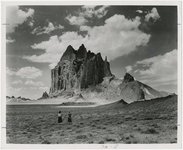
Shiprock
1945; 1946; 1947; 1948; 1949; 1950; 1951; 1952; 1953; 1954; 1955; 1956; 1957; 1958; 1959; 1960; 1961; 1962; 1963; 1964; 1965
Image
uum_map
125
The shortest route to California illustrated by a history of explorations of the Great Basin of Utah with its topographical and geological character and some account of the Indian tribes
Text
uaida_main
101
-
125
of
163
<
1
2
3
4
5
6
7
>