Home
Browse
Ask Us
Chat
Harmful Language Statement
Log in
Advanced Search
Year
1854
1855
1856
1857
1858
1859
1860
1861
1862
1863
1864
1865
1866
1867
1868
1869
1870
1871
1872
1873
1874
1875
1876
1877
1878
1879
1880
1881
1882
1883
1884
1885
1886
1887
1888
1889
1890
1891
1892
1893
1894
1895
1896
1897
1898
1899
1900
1901
1902
1903
1904
1905
1906
1907
1908
1909
1910
1911
1912
1913
1914
1915
1916
1917
1918
1919
1920
1921
1922
1923
1924
1925
1926
1927
1928
1929
1930
1931
1932
1933
1934
1935
1936
1937
1938
1939
1940
1941
1942
1943
1944
1945
1946
1947
1948
1949
1950
1951
1952
1953
1954
1955
1956
1957
1958
1959
1960
1961
1962
1963
1964
1965
1966
1967
1968
1969
1970
1971
1972
1973
1974
1975
1976
1977
1978
1979
1980
1981
1982
1983
1984
1985
1986
1987
1988
1989
1990
1991
1992
1993
1994
1995
1996
1997
1998
1999
2000
2001
2002
2003
2004
2005
2006
2007
2008
2009
TO
1854
1855
1856
1857
1858
1859
1860
1861
1862
1863
1864
1865
1866
1867
1868
1869
1870
1871
1872
1873
1874
1875
1876
1877
1878
1879
1880
1881
1882
1883
1884
1885
1886
1887
1888
1889
1890
1891
1892
1893
1894
1895
1896
1897
1898
1899
1900
1901
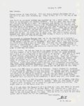
1902
1903
1904
1905
1906
1907
1908
1909
1910
1911
1912
1913
1914
1915
1916
1917
1918
1919
1920
1921
1922
1923
1924
1925
1926
1927
1928
1929
1930
1931
1932
1933
1934
1935
1936
1937
1938
1939
1940
1941
1942
1943
1944
1945
1946
1947
1948
1949
1950
1951
1952
1953
1954
1955
1956
1957
1958
1959
1960
1961
1962
1963
1964
1965
1966
1967
1968
1969
1970
1971
1972
1973
1974
1975
1976
1977
1978
1979
1980
1981
1982
1983
1984
1985
1986
1987
1988
1989
1990
1991
1992
1993
1994
1995
1996
1997
1998
1999
2000
2001
2002
2003
2004
2005
2006
2007
2008
2009
Type
Image/StillImage
125
Image
70
Text
41
Format
application/pdf
248
Collection
Mormon Settlement in Arizona
38
Photo Archives
15
Utah River Running Photo Archives
192
Western Waters NEH
3
Filters:
Format:
"application/pdf"
Spatial Coverage:
"Coconino County (Ariz.)"
201
-
225
of
248
<
1
2
3
4
5
6
7
8
9
10
>
Gallery view
Number of results to display per page
10
25
50
100
200
Sort by Relevance
Sort by Title A-Z
Sort by Title Z-A
Sort by Date Ascending
Sort by Date Descending
Sort by Last Modified Ascending
Sort by Last Modified Descending
Title
Date
Type
Setname
201
Norman D. Nevills' 1938 Green and Colorado Rivers expedition. Surveying rapids at Horn Creek Rapid.
1938-07-22
Image
uum_map_rr
202
Norman D. Nevills' 1938 Green and Colorado Rivers expedition. The boats "WEN" and "Mexican Hat" pulled out of rapids, left to right, Elzada Clover, Norm Nevills, Lois Jotter and Lorin Bell.
1938-07-13; 1938-07-14; 1938-07-15; 1938-07-16; 1938-07-17; 1938-07-18; 1938-07-19; 1938-07-20; 1938-07-21; 1938-07-22; 1938-07-23; 1938-07-24; 1938-07-25; 1938-07-26; 1938-07-27; 1938-07-28; 1938-07-29; 1938-07-30; 1938-07-31; 1938-08-01
Image
uum_map_rr
203
Norman D. Nevills' 1938 Green and Colorado Rivers expedition. The Colorado River just below Bright Angel Bridge.
1938-07-22
Image
uum_map_rr
204
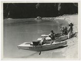
Norman D. Nevills' 1938 Green and Colorado Rivers expedition. The Nevills party at Bright Angel Creek with the boats "Mexican Hat," WEN" and "Botany" on shore, July 22, 1938.
1938-07-22
Image
uum_map_rr
205
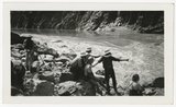
Norman D. Nevills' 1938 Green and Colorado Rivers expedition. Thirty-five foot wave at Hermit Falls, Grand Canyon. Norm Nevills and Elzada Clover in and next to "WEN" in the foreground.
1938-07-22; 1938-07-23
Image
uum_map_rr
206
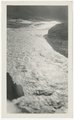
Norman D. Nevills' 1938 Green and Colorado Rivers expedition. Vasey's Paradise Waterfall.
1938-07-16
Image
uum_map_rr
207
Norman D. Nevills' 1938 Green and Colorado Rivers expedition. Vasey's Paradise Waterfall.
1938-07-16
Image
uum_map_rr
208
Norman D. Nevills' 1938 Green and Colorado Rivers expedition. View of the Colorado River and Grand Canyon.
1938-07-08; 1938-08-01
Image
uum_map_rr
209
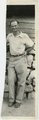
Norman D. Nevills, Grand Canyon, July 20, 1938.
1938-07-20
Image
uum_map_rr
210
North Boundary of the Hualapai Reservation
2009-08-25
Text
wwdl_neh
211
North Rim, Grand Canyon
1925; 1926; 1927; 1928; 1929; 1930; 1931; 1932; 1933; 1934; 1935; 1936; 1937; 1938; 1939; 1940; 1941; 1942; 1943; 1944; 1945; 1946; 1947; 1948; 1949
Image
uum_map_rr
212
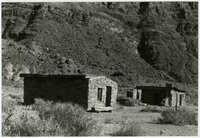
Oldest buildings at Lee's Ferry, just downstream from old Ferry site
1985-11
uum_map_rr
213
P. T. Reilly correspondence with George S. Tanner, 1968
1969
Text
uum_msa
214
P. T. Reilly correspondence with George S. Tanner, 1969
1970
Text
uum_msa
215
P. T. Reilly correspondence with George S. Tanner, 1970
1971
Text
uum_msa
216
P. T. Reilly correspondence with George S. Tanner, 1971
1972
Text
uum_msa
217
P. T. Reilly correspondence with George S. Tanner, 1972
1973
Text
uum_msa
218
P. T. Reilly correspondence with George S. Tanner, 1973
1974
Text
uum_msa
219
P. T. Reilly correspondence with George S. Tanner, 1974
1975
Text
uum_msa
220
P. T. Reilly correspondence with George S. Tanner, 1975
1976
Text
uum_msa
221
P. T. Reilly correspondence with George S. Tanner, 1976
1977
Text
uum_msa
222
P. T. Reilly correspondence with George S. Tanner, 1977
1978
Text
uum_msa
223
P. T. Reilly correspondence with George S. Tanner, 1978
1978
Text
uum_msa
224
P. T. Reilly correspondence with George S. Tanner, 1979
1979
Text
uum_msa
225
P. T. Reilly correspondence with George S. Tanner, 1980
1980
Text
uum_msa
201
-
225
of
248
<
1
2
3
4
5
6
7
8
9
10
>