Home
Browse
Ask Us
Chat
Harmful Language Statement
Log in
Theses & Dissertations
Advanced Search
Year
1960
1961
1962
1963
1964
TO
1960
1961
1962
1963
1964
Type
Image
10
Text
1
Format
application/pdf
6
application/vnd.google-earth.kmz
2
application/zip
2
Collection
Theses & Dissertations
10
Filters:
Department:
"Mining Engineering"
Type:
"Image"
1
-
25
of
10
Gallery view
Number of results to display per page
10
25
50
100
200
Sort by Relevance
Sort by Title A-Z
Sort by Title Z-A
Sort by Date Ascending
Sort by Date Descending
Sort by Last Modified Ascending
Sort by Last Modified Descending
Title
Date
Type
1
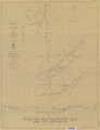
Alteration and trace elements of volcanics in the San Francisco Mountains
1964-06
Text; Image
2
Alteration and trace elements of volcanics in the San Francisco Mountains (Google Earth map overlay KMZ file)
1964-06
Image
3
Alteration and trace elements of volcanics in the San Francisco Mountains: Georeferenced map files
1964-06
Image
4
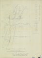
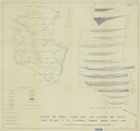
Economic geology of the sulphur deposits at Sulphurdale, Utah-Maps
1960-08
Image
5
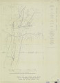
Economic geology of the sulphur deposits at Sulphurdale, Utah: Georeferenced map files
1960-08
Image
6
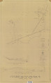
Plate 1: Geologic map and vertical cross section of the Sulphurdale sulphur deposits, Beaver and Millard Counties, Utah
1960-08
Image
7
Plate 1: Geologic map and vertical cross section of the Sulphurdale sulphur deposits, Beaver and Millard Counties, Utah (Google Earth map overlay KMZ file)
1960-08
Image
8
Plate 2: Detailed geologic and vertical cross sections map of the Excelsior Orebody and New York Prospect Pit, Millard County, Utah
1960-08
Image
9
Plate 3: Detailed geologic and vertical cross section map of the Prince Albert Orebody, Mariposa and Queen Victoria Prospect Pits, Millard County, Utah
1960-08
Image
10
Plate 4: Detailed map showing diamond drill hole locations and vertical cross sections of the Sulphurdale Orebody, Beaver County, Utah
1960-08
Image
1
-
25
of
10