|
|
Author | Title | Subject | Date | Publication Type |
| 226 |
 |
Vlam, Heber Adolf Arien | Petrology of Lake Bonneville Gravels Salt Lake County, Utah | Petrology; Utah; Salt Lake County; Bonneville; Thesis and dissertation georeferencing project | 1963-05 | thesis |
| 227 |
 |
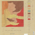
Vlam, Heber Adolf Arien | Petrology of Lake Bonneville Gravels Salt Lake County, Utah: Georeferenced map files | Petrology; Utah; Salt Lake County; Bonneville; Lake | 1963-05 | thesis |
| 228 |
 |
Van Deventer, Bruce Robert | Petrology of the moenkopi formation (Early Triassic), Uinta Mountain Area, Northeastern Utah | Petrology; Utah; Moenkopi formation; Thesis and dissertation georeferencing project | 1974-06 | thesis |
| 229 |
 |
Gorenc, Marko Anton | Petrophysical and diagenetic characteristics of the permian white rim sandstone, southeast utah | Diagenesis; Hydrocarbons; Iron Oxide; Utah | 2015-08 | thesis |
| 230 |
 |
Smith, Hugh Preston | Plate 1 Fence diagram Moenkopi group (Google Earth map overlay KMZ file) | Geology; Utah; Thaynes Formation; Moenkopi group | 1969-06 | thesis |
| 231 |
|
Mann, Daven Craig | Plate 1 Generalized geologic map of the Laramide orogenic sediments of the Wasatch Hinterland (Google Earth map overlay KMZ file) | Sediments (Geology); Utah; Wasatch Hinterland | 1974 | thesis |
| 232 |
|
Chapusa, Frank W. P. | Plate 1 Geologic map of Stansbury Island, Tooele County, Utah (Google Earth map overlay KMZ file) | Geology; Utah; Stansbury Island | 1969-06 | thesis |
| 233 |
|
Cohenour, Robert E. | Plate 1 Geologic map of the Sheeprock Mountains area, Utah (Google Earth map overlay KMZ file) | Geology -- Utah -- Sheeprock Mountains; Geology -- Utah -- Tooele County; Geology -- Utah -- Juab County; Thesis and dissertation georeferencing project | 1957-08 | thesis |
| 234 |
 |
Brox, George Stanley | Plate 1: Geologic map of Northern Bryce Canyon National Park | | 1961-06 | thesis |
| 235 |
 |
Neff, Thomas Rodney | Plate 1: Geologic map of the Little Willow Series, Wasatch Mountains, Utah | | 1962-11 | thesis |
| 236 |
 |
Blakey, Ronald Clyde | Plate 1: Geologic map of the Paria NW quadrangle, Kane County, Utah | | 1970-08 | thesis |
| 237 |
|
Baker, Walker Holcombe | Plate 1: Geologic map of the Southern Grouse Creek Mountains, Box Elder County, Utah (Google Earth map overlay KMZ file) | Geology--Utah; Thesis and dissertation georeferencing project | 1959-06 | thesis |
| 238 |
 |
Sadeghi, Ali Reza | Plate 1: Geologic map of the Willard Peak area, North-Central Wasatch Mountains, Utah | | 1972-12 | thesis |
| 239 |
|
Sadeghi, Ali Reza | Plate 1: Geologic map of the Willard Peak area, North-Central Wasatch Mountains, Utah (Google Earth map overlay KMZ file) | Geology -- Structural -- Utah -- Willard Peak area; Thesis and dissertation georeferencing project | 1972-12 | thesis |
| 240 |
 |
Schaeffer, Frederick Ernst Jr. | Plate 1B: Geologic map of the Central and Southern Silver Island Mountains, Box Elder and Tooele Counties, Utah, and Elko County, Nevada | | 1961-06 | thesis |
| 241 |
|
Schaeffer, Jr. Frederick Ernst | Plate 1B: Geologic map of the Central and Southern Silver Island Mountains, Box Elder and Tooele Counties, Utah, and Elko County, Nevada (Google Earth map overlay KMZ file) | Thesis and dissertation georeferencing project | 1961-06 | thesis |
| 242 |
 |
Schaeffer, Frederick Ernst Jr. | Plate 1C: Geologic cross sections of the Central and Southern Silver Island Mountains, Box Elder and Tooele Counties, Utah and Elko County, Nevada | | 1961-06 | thesis |
| 243 |
 |
Johnson, Eric Henry | Plate 2 Topography, resistivity, and chargeability cross-sections along dipole-dipole line 1 on Fumarole Butte | Basalt -- Utah; Geothermal resources -- Utah | 1975-08 | thesis |
| 244 |
 |
Neff, Thomas Rodney | Plate 2: Sections along line A-A' and B-B' | | 1962-11 | thesis |
| 245 |
 |
Blakey, Ronald Clyde | Plate 2: Structural sections | | 1970-08 | thesis |
| 246 |
 |
Sadeghi, Ali Reza | Plate 2: Structure sections for geologic map of the Willard Peak area | | 1972-12 | thesis |
| 247 |
|
Hooper, Warren G. | Plate 3 Geologic map of portion of Northwestern Uinta Mountains, Utah (Google Earth map overlay KMZ file) | Geology -- Uinta Mountains (Utah and Wyo.); Thesis and dissertation georeferencing project | 1951 | thesis |
| 248 |
 |
Johnson, Eric Henry | Plate 3 Topography, resistivity, and chargeability cross-sections along dipole-dipole line 2 on Fumarole Butte | Basalt -- Utah; Geothermal resources -- Utah | 1975-08 | thesis |
| 249 |
 |
Mount, Donald Lee | Plate 3: Geologic map and sections of Wanship-Park City region, Utah | | 1952-06 | thesis |
| 250 |
|
Mount, Donald Lee | Plate 3: Geologic map and sections of Wanship-Park City region, Utah (Google Earth map overlay KMZ file) | Geology -- Utah -- Summit County | 1952-06 | thesis |