|
|
Author | Title | Subject | Date | Publication Type |
| 1 |
 |
Warnick, Richard Michael | A digital atlas of Utah wilderness | Atlas; geography; GIS; public lands; Utah; wilderness | 2011-12 | thesis |
| 2 |
 |
Mueller, Joshua Robert | A history of paleotempestology and paleoecology from the British Virgin Island | Biology; Caribbean Studies; Climate Change; Ecology | 2018 | dissertation |
| 3 |
 |
Howard, Kelsey Ann | A late pleistocene to early holocene climate, vegetation and fire history record for the bonneville basin, utah, usa | Bonneville Basin; Climate; Vegetation; Fire History; Heinrich Events; Lake Bonneville; Paleoecology; Paleo Indians | 2016-05 | thesis |
| 4 |
 |
Li, Yingru | A multilevel analysis of China's regional inequality in a geographic information system environment | China regional development; China economic development; China socioeconomic | 2012-05 | dissertation |
| 5 |
 |
Wellard, Blake H. | A new ancestral diploid species of echinocereus endemic to southwestern utah and northern arizona | Cactaceae; Caryophyllales; Conservation; Diploid; Echinocereus; Morphomertics | 2017 | thesis |
| 6 |
 |
Carter, Vachel Ashley | A paleoecological fire and vegetation history in Southeastern Wyoming | Fire; Paleoecology; Vegetation; Wyoming | 2010-08 | thesis |
| 7 |
 |
Higby Halseth, Deanna Renee | A paleolimnological investigation of historical environmental change in East Canyon Reservoir | East Canyon Reservoir; Paleolimnology; Remote sensing; Reservoir; Utah; Water resources | 2011-05 | thesis |
| 8 |
 |
Zhang, Yuan | A rangeland predictive phenological model for the upper Colorado River Basin and its web delivery | Decision support system; Multivariate adaptive regression splines; Phenological modeling; Phenology; Remote sensing; Upper Colorado River Basin | 2013-08 | dissertation |
| 9 |
 |
McCoy, William Dennis | A reinterpretation of certain aspects of the late quaternary glacial history of little Cottonwood Canyon, Wasatch Mountains, Utah | | 1977 | thesis |
| 10 |
 |
Li, Yingxie | A Web-based application for home loss notification in wildfires | | 2017 | thesis |
| 11 |
 |
Morris, Stacy Randolph | After the Fremont: fire and vegetation history of prehistoric abandonment and historic occupation of Range Creek Canyon, Utah | Fire, Fremont; Native American; Range Creek Canyon; Vegetation | 2010-08 | thesis |
| 12 |
 |
McDonald, Kaila | Air pollution and fetal development: Fine particulate matter and preterm birth in Utah (2005-2008) | | 2018 | thesis |
| 13 |
 |
Spencer, Jessica D. | An 8,000-year fire and vegetation history of an oak savanna in East Central Minnesota | Charcoal; Fire; Minnesota; Oak savanna; Pollen; Sherburne | 2012-05 | thesis |
| 14 |
 |
Groeneveld, Joshua Andrew | An agent-based model of bicyclists accessing light-rail stations in Salt Lake City | Agent-based model; Bicycle; Mulitmodal; NetLogo; Salt Lake City, Utah | 2011-08 | thesis |
| 15 |
 |
Kobayashi, Tetsuo | An interactive visualization tool for mobile objects | Exploratory data analysis; GIS; Mobile object; Visualization | 2010-08 | dissertation |
| 16 |
 |
Zumbado, Thomas Calderon | An investigation of the philosophical changes of the Abu Sayyaf group using geospatial analysis | Abu sayyaf group; Crime; Geospatial; Philippines; Terrorism; Transformatio | 2011-08 | thesis |
| 17 |
 |
Johnson, Allen Cole | Analysis and Prediction of Utah Transit Authority Service Areas | | 1972 | thesis |
| 18 |
 |
Culpepper, Patrick John | Analysis of terrestrial ground-based lindar datasets on active lava flow processes and the geomorphology of Pu'u O'o, Hawaii | LiDAR system; Pahoehoe flow; Volcanic hazard mitigation | 2009-04-27 | thesis |
| 19 |
 |
Cao, Lina | Anthropogenic habitat disturbance and the dynamics of hantavirus using remote sensing, GIS, and a spatially explicit agent-based model | Agent-based model; Deer mouse; GIS; Hantavirus; MODIS; Peromyscus maniculatus | 2010-08 | dissertation |
| 20 |
 |
Bares, Ryan | The application of stable carbon isotopes as an enhanced method for statistical crossdating: A case study from Range Creek Canyon, Utah | Geography; Biogeochemistry | 2014 | thesis |
| 21 |
 |
Selkowitz, David James | Automated approaches for snow and ice cover monitoring using optical remote sensing | Geography | 2017 | dissertation |
| 22 |
 |
Naisbitt, Adam | Avalanche frequency and magnitude: using power-law exponents to investigate snow avalanche size proportions through time and space | Avalanche forecasting; Avalanche models | 2008-05-31 | thesis |
| 23 |
 |
Fu, Liwei | Bicycling preferences and behavior in salt lake city | attitude; bicycling frequency; preferences; route choice; values | 2015 | thesis |
| 24 |
 |
Nishizawa, Shizuo | Bonneville lake basin shoreline records of large lake and abrupt climate change events | Abrupt climate change events; Lake Bonneville; Lake surface area; Monsoons; Shoreline records | 2010-07 | dissertation |
| 25 |
 |
Bidez, Clarice Lee | Changing agricultural suitability: model development and applications in the past and future | Physical geography; Geography; Agriculture | 2018 | thesis |
| 26 |
 |
Miller, Julie | Characterizing the relationship between Ku-band radar backscatter and snow accumulation on the Greenland ice sheet | Greenland ice sheet; Scatterometry; Snow accumulation | 2012-12 | thesis |
| 27 |
 |
Farnham, Delanie R | Child growth as a measure of resilience to food insecurity in burkina faso | Burkina Faso; Childhood Malnutrition; Food Security; Quantile Regression; Resilience | 2017 | thesis |
| 28 |
 |
Davis, Andrea Nicole | Childhood undernutrition within the dry zone of Myanamr: does geographic location influence health outcomes? | Southeast Asian studies; Geography; Nutrition | 2017 | thesis |
| 29 |
 |
Chavez, Vanessa Grace | Climatic influences on two cienega complexes from northern baja california: a ~45,000 year paleoecological record | Baja California; ENSO; Fire; Late-glacial; Monsoon | 2016 | thesis |
| 30 |
 |
Reynolds, Joshua Deshawn | Comparing urban vegetation cover with summer land surface temperature in the Salt Lake Valley | Land Surface Temperature; Lidar; Orthoimagery; Random Forest; Salt Lake; Urban Forest | 2017 | thesis |
| 31 |
 |
Mcnerney, Laura | Constraining the greenland firn aquifer's ability to hydrofracture a crevasse to the bed of the ice sheet | crevasses; fluid dynamics; Greenland ice sheet; groundwater flow; hydrofracture | 2016 | thesis |
| 32 |
 |
Unger, Corey Daniel | Creating spatial data infrastructure to facilitate the collection and dissemination of geospatial data to aid in disaster management | Disaster management; Geographic information systems; GIS; SDI; Spatial data infrastructure; Volunteer geographic information | 2015-05 | thesis |
| 33 |
 |
Hansen, Matthew Kade | Decision tree classification of dambo wetlands using remotely sensed multispectral and topographic data | Vegetation mapping,Uganda;Wetland ecology, Uganda; Methane,Environmental aspects, Uganda;Remote sensing,Uganda | 2008-08 | thesis |
| 34 |
 |
Smith, Kathryn L | Developing emergency preparedness indices for local governments | Emergency; Index; Preparedness | 2010 | thesis |
| 35 |
 |
Smith, Gregory E | Development of a flash flood potential index using physiographic data sets within a geographic information system | Flash flood; Storm runoff | 2010 | thesis |
| 36 |
 |
Liu, Meitong | Economic-environmental imbalance of air pollution in China: patterns, determinants, and environmental justice implications | | 2020 | thesis |
| 37 |
 |
Lloyd, Brent Joseph | Evaluating health and farming methods in burkina faso | | 2019 | dissertation |
| 38 |
 |
Latham, Paris Walker | Evaluating the effects of snowstorm frequency and depth on skier behavior in Big Cottonwood Canyon, Utah | Geography; Recreation | 2017 | thesis |
| 39 |
 |
Matheson, Daniel Scott | Evaluating the effects of spatial resolution on hyperspectral fire detection and temperature retrieval | Physical geography; Geographic information science; Remote sensing | 2011-08 | thesis |
| 40 |
 |
Headman, Alexander O. | Evaluation of fire regime shifts in boreal Alaska through the use of sedimentary charcoal | Pure sciences; Health and environmental sciences; Earth sciences; Paleoecology; Statistics; Environmental science | 2016 | thesis |
| 41 |
 |
Siebeneck, Laura Kathryn | Examining the geographic dimensions of risk perception, communication, and response during the evacuation and return-entry process | Cedar rapids; Evacuation; Flood; Hazards; Return-entry; Geography; Urban planning | 2010 | dissertation |
| 42 |
 |
Graves, Scott Andrew | Examining vegetation phenology of Ugandan dambos using spectral mixture modeling fractions | Vegetation mapping, Uganda;Wetland ecology, Uganda; Methane, Environmental aspects, Uganda | 2008-05 | thesis |
| 43 |
 |
Balzotti, Christopher Stephen | Exploring the use of fine resolution nested ecological niche models to identify greater sage-grouse (Centrocercus urophasianus) habitat and connectivity potential across a diverse landscape | Climate change; Habitat model; Landscape ecology; Niche model; Sagebrush; Sage-grouse | 2014-12 | dissertation |
| 44 |
 |
Van Drimmelen, Marquessa Nixon | Family gathering in evacuations: a case-study of the 2007 Angora fire | Evacuation; Family gathering; Fire | 2010-08 | thesis |
| 45 |
 |
Turrin, James Bradley | Flow instabilities of Alaskan glaciers | Glaciers; Climate change; Alaska | 2014-08 | dissertation |
| 46 |
 |
Freeman, Michael Lawrence | Flow reversal events and statistical modeling of flow dynamics of hypersaline water across a constructed causeway, Great Salt Lake, Utah, USA | flow reversals; generalized additive model; Great Salt Lake; hydrodynamics; statistical modeling | 2014-08 | thesis |
| 47 |
 |
Liao, Haifeng | Geographic information system spatial analysis of urban and regional development in China: a case study of Guangdong Province | | 2014-08 | dissertation |
| 48 |
 |
Huang, Hao | Geographic information system spatial-temporal evolution of multiscalar patterns and determinants of foreign direct investment in China | China; Foreign direct investment; GIS; Patterns and determinants; Spatial-temporal evolution; Wuhan | 2014-08 | dissertation |
| 49 |
 |
Nicolosi, Emily Ann | Geographies of climate change mitigation: an exploration of the climate change movement | carbon footprint; climate change; climate change mitigation; geography; social movements; Transition Towns | 2015 | thesis |
| 50 |
 |
Nicolosi, Emily Ann | Geographies of grassroots sustainabilities: mapping the places and spaces of transition | | 2019 | dissertation |
| 51 |
 |
Thom, Derrick J. | The geography of Heber Valley | | 1965 | thesis |
| 52 |
 |
Richan, F. Partridge | The geography of Pavant Valley, Utah | | 1957 | thesis |
| 53 |
 |
Meadows, Michelle Kristine | High frequency variability in glacier meltwater patterns in the rhone watershed, switzerland | Glacier hydrology; Glacier meltwater; Glaciology | 2017 | thesis |
| 54 |
 |
Morris, Jesse Lee | Historic and holocene forest disturbance in South-Central Utah | Forest disturbance; Holocene; Dendroctonus; Engelmann spruce; Fire; Lake sediments; Picea; Spruce beetle | 2011-08 | dissertation |
| 55 |
 |
Ward, Danielle Marie | Holocene chemostratigraphy of spring sediments in Range Creek Canyon, Utah | | 2016 | thesis |
| 56 |
 |
Turney, Lovina Abbott | Holocene climate, vegetation, and fire linkages in the Uinta Mountains, Utah | Charcoal; Climate; Holocene; Pollen | 2014-12 | thesis |
| 57 |
 |
Langtry, Shirley Ann Daniels | Housing selection: a study of the geographic and sociologial factors influencing housing choice in a sub-community of Salt Lake City | | 1972 | thesis |
| 58 |
 |
Burgess, Ann Bryant | Hydrologic impacts of dust on snow in the Upper Colorado River Basin | Dust; Energy balance; Snow | 2014-05 | dissertation |
| 59 |
 |
Coates, Austin Reece | Hyperspectral remote sensing for monitoring species-specific drought impacts in Southern California | Drought; Hyperspectral; Species-Specific; Spectral Mixture Analysis | 2015 | thesis |
| 60 |
 |
Burgess, Evan Windam | Ice flow dynamics of Alaska glaciers | Alaska; Glaciers; Glaciology; Ice dynamics; Offset tracking; Remote sensing | 2013-05 | dissertation |
| 61 |
 |
Olson, Matthew Howard | Impacts of topographic shading on surface energy balance of High Mountain Asia glaciers | Climate Change; Atmospheric sciences; Remote sensing | 2017 | thesis |
| 62 |
 |
Wagner, Jonathan | Incorporating in situ albedo observations with a spatial snowmelt model in a dust-dominated basin | | 2020 | thesis |
| 63 |
 |
Li, Han | Institutions, economic transition, and urban land expansion in China | China; Economic Transition; Institutions; Urban Expansion | 2016 | dissertation |
| 64 |
 |
Skiles, S; McKenzie | Interannual variability in radiative forcing by desert dust in snowcover in the Colorado River Basin | Colorado River Basin; Cryosphere; Snowmelt; Interannual variability | 2010 | thesis |
| 65 |
 |
Hafey, Mark Hanner Jr. | Land use change : the impact of the traditional process of land use change on the Sumner neighborhood in Salt Lake City | City planning -- Utah -- Salt Lake City Land use -- Utah -- Salt Lake City | 1974 | thesis |
| 66 |
 |
Looby, Elizabeth | Late holocene climate change in the Tigray Plateau, Ethiopia | | 2019 | thesis |
| 67 |
 |
Blissett, Shawn D | Late holocene history of vegetation, fire, and climate from a desert wetland in Southwest North America | Cienega; Desert wetland; Medieval climate anomaly; Paleo fire record; Palynology; Southwest north america; Paleoclimatology | 2010 | thesis |
| 68 |
 |
Kimball, James Patrick | Late quaternary environmental change as inferred from diatoms of the sediments of Bear Lake, Utah/Idaho | | | thesis |
| 69 |
 |
Pulver, Aaron Thomas | Locating automated external defibrillator enabled medical drones to reduce response times to out-of-hospital cardiac arrests | backup coverage; geographic information systems; location modeling; medical drone; out-of-hospital cardiac arrest; spatial optimization | 2017 | thesis |
| 70 |
 |
Koll, Rebecca Ann | Long-term vegetation, climate, and fire history in the Eastern Uinta Mountains, Utah, U.S.A. | | 2012-05 | thesis |
| 71 |
 |
Jin, Zhenyu | Mapping and spatial-temporal modeling of Bromus tectorum invasion in Central Utah | Cheatgrass; NDVI time-series; Remote sensing; Spatial-temporal modeling; Utah; Bromus tectorum | 2011-11 | dissertation |
| 72 |
 |
Dudley, Kenneth | Mapping species across multiple dates of hyperspectral imagery using iterative endmember selection and multiple endmember spectral mixture analysis | Endmember selection; Hyperspectral time series; HyspIRI; MESMA; Species classification; Vegetation phenology | 2014-12 | thesis |
| 73 |
 |
Welker, Chelsea | Master of Geographic Information Science | Geography--Research--United States | 2017 | online portfolio |
| 74 |
 |
Eichorn, Michael | Master of Geographic Information Science Portfolio | Geography--Research--United States; Remote sensing | 2017 | online portfolio |
| 75 |
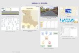 |
Rivera, Sarah | Master of Geographic Information Science Portfolio | Geography - information services | 2017 | online portfolio |
| 76 |
 |
Ottesen, Mitchell | Master of Geographic Information Science Portfolio | Geography--Research--United States; Cartography--United States | | online portfolio |
| 77 |
 |
Cheng, Siwen | Master of Geographic Information Science Portfolio | Geography - Research - information services | 2017 | thesis |
| 78 |
|
Eichorn, Micheal | Master of Geographic Information Science portfolio | Geography - Research - Information services | 2017 | online portfolio |
| 79 |
 |
Theobald, Megan | Master of geographic science informatoin portfolio | Geography--Research--United States | | online portfolio |
| 80 |
 |
Turrin, James Bradley | Measuring glacier velocities on the Kenai Peninsula, Alaska, using multispectral satellite imagery with feature tracking | Glaciers--Alaska; Glaciology; Aerial photography | 2010-03-20 | thesis |
| 81 |
 |
Arnold, James D. | Modeling climate-fire connections within the Great Basin and Upper Colorado River Basin, Western United States | Climate; Maxent; Modeling; Spatial; Western U.S.; Wildfire | 2013-05 | thesis |
| 82 |
 |
Bailey, Vanessa J. | Modeling vegetation distribution and carbon sequestration in the Pacific Northwest | Ecology; Physical geography; Climate change | 2018 | thesis |
| 83 |
 |
Li, Dapeng | Modeling wildfire evacuation as a coupled human-environmental system using triggers | fire spread modeling; GIS; reverse geocoding; traffic simulation; triggers; wildfire evacuation | 2016 | dissertation |
| 84 |
|
Li, Dapeng | Modeling wildfire evacuation as a coupled human-environmental system using triggers | fire spread modeling; GIS; reverse geocoding; traffic simulation; triggers; wildfire evacuation | 2016 | dissertation |
| 85 |
 |
Arnold, Steven | MSGIS Portfolio | | 2016-12 | online portfolio |
| 86 |
 |
Maezumi, Shira Yoshimi | Neotropical climate, vegetation, and fire histories on local to regional scales | Amazon; Bolivia; Paleoecology; Paleofire; Phytoliths; Pollen | 2015-05 | dissertation |
| 87 |
 |
Qi, Yi | New physical foundations for remote sensing estimation of live fuel moisture content and fire danger | live fuel moisture content; remote sensing | 2014 | dissertation |
| 88 |
 |
Gold, Brittany | Observations of diurnal melt-freeze events using time domain reflectometry (TDR) in sesonal snowpack | Melt-freeze; Snow; TDR | 2014-08 | thesis |
| 89 |
 |
Baskin, Robert LeRoy | Occurrence and spatial distribution of microbial bioherms in Great Salt Lake, Utah | Distribution; Great Salt Lake; Microbial bioherm; Microbialite; Stromatolite; Thrombolite | 2014-12 | dissertation |
| 90 |
 |
Lundeen, Zachary J. | Paleoecological and isotropic records of climate change and variability from lakes and speleothems, Bear River Range, Southeastern Idaho | Holocene; Idaho; Paleoclimate; Paleoecology; Pollen; Speleothem | 2012-12 | dissertation |
| 91 |
 |
Balen, John Adrianus van | Plant cover types of the upper Bear River drainage, Utah. | Vegetation mapping | 1973 | thesis |
| 92 |
 |
Wenrich, Erika Ann | Quantifying drought-induced changes in green vegetation fraction and classification accuracy using hyperspectral data for the Central Sierra Nevada, California | Geography; Forestry; Remote sensing | 2017 | thesis |
| 93 |
 |
Miege, Clement | Recent ice sheet snow accumulation and firn storage of meltwater inferred by ground and airborne radars | Antarctica; Aquifer; Firn; Greenland; Radar | 2015-08 | dissertation |
| 94 |
 |
Housman, Ian Wilson | Recent trends in the changing geographic extent of Cienegas of the United States/Mexico border region | Ciénega; Desiccation; GIS; Landsat; Remote sensing; Wetlands | 2011-05 | thesis |
| 95 |
 |
Macharia, Anthony Njuguna | Reconstructing paleoenvironments using a mass-energy flux framework | Diatoms; Palynology; Sediments; Soils; Stable isotopes; Woody cover | 2012-12 | dissertation |
| 96 |
 |
Fuhriman, Christopher | Reimagined territory: a new theory of terrorist geographies | Geography | 2017 | dissertation |
| 97 |
 |
Johnson, Eric Scott | Relative contributions of precipitation-induced melt feedbacks to regional glacier mass balance in High Mountain Asia | Geography; Climate Change | 2017 | thesis |
| 98 |
 |
Campbell, Michael James | Remote sensing and geospatial modeling of wildland firefighter safety | Remote sensing | 2018 | dissertation |
| 99 |
 |
| Remote sensing: green coverage area in Salt Lake City | Geography--Research--United States; Remote sensing | | online portfolio |
| 100 |
 |
Zhang, Ling | Retail internationalization and urban restructuring in china: a study of foreign hypermarkets and urban land with geographic information system and remote sensing | China; hypermarket; land use; retail internationalization; Suzhou; urban growth | 2016 | dissertation |
| 101 |
 |
Carter, Vachel Ashley | The role of climate variability and disturbances on forest ecology in the intermountain west | climate change; disturbance; Intermountain West; Rocky Mountains; vegetation change | 2016 | dissertation |
| 102 |
 |
Butler, Jared Thomas | The role of early life socioeconomic status in female breast cancer incidence | Breast cancer; Clustering; Incidence; Life course; Socioeconomic; Utah | 2013-12 | thesis |
| 103 |
 |
Baustian, Kate | Seasonal and spatial distribution of wet snow on three volcanoes in Western Washington mapped with synthetic aperture radar | | 2019 | thesis |
| 104 |
 |
Groves, Mariangelica | Seasonal moisture and fire variability in the Northern Colorado Plateau: a case study in Rage Creek Canyon, UT | | 2019 | dissertation |
| 105 |
 |
Morris, Jesse L | Sedimentological evidence of late holocene disturbance on the Wasatch Plateau, Utah, USA | Forest ecology; Paleoecology | 2008-05 | thesis |
| 106 |
 |
Martineau, Eric Lee | Seismic risk perception and household adjustment in Salt Lake City, Utah | Geography | 2012 | thesis |
| 107 |
 |
Ackroyd, Chelsea Seutatia | Snow cover trends over high Mountain asia from modis snow cover and grain size | | 2019 | thesis |
| 108 |
 |
Glassett, John Deloy | South American Immigration to Utah | | 1972 | thesis |
| 109 |
 |
Bishop, Seth Arthur | Spatial access and local demand for emergency medical services in utah | 2SFCA; accessibility; ambulance; emergency medical service; floating catchment area; spatial access | 2016 | thesis |
| 110 |
 |
Christiansen, Jennifer Laura | Spatial and aspatial residential segregation measures: Salt Lake County 1999 to 2007 | Diversity; Segregation in Utah | 2009-07-06 | thesis |
| 111 |
 |
Heyer, Joshua P | Spatial correlation analysis of niÑo3.4 sea surface temperatures with western north america hydroclimate | El Nino Southern Oscillation; Headwaters; Hydroclimate; Synoptic Climatology; Teleconnections; Western North America | 2016 | thesis |
| 112 |
 |
Miller, Sandra Tremblay | Spatial modeling of wildland fire ignition potential in Utah | | 2019 | thesis |
| 113 |
 |
Li, Xiao | Spatial representation in the social interaction potential metric: an analysis of scale and parameter sensitivity | Joint accessibility; Sensitivity analysis; Social interaction potential metric; Time geography | 2015-05 | thesis |
| 114 |
 |
Burgess, Evan W | Spatially calibrated model of annual accumulation rate on the Greenland ice sheet (1958-2007) | Ice sheets--Greenland | 2009-01-04 | thesis |
| 115 |
 |
Meng, Ran | Study of two vegetation-related disturbances (beetle herbivory and wildfire) in the western united states using optical remote sensing | Change detection; Disturbance ecology; Remote sensing classification; Spaital analysis; Statistical modeling; Vegetation recovery | 2015 | dissertation |
| 116 |
 |
Murany, Ernest E. | Subsurface stratigraphy of the Wasatch Formation of the Uinta Basin, Utah (Google Earth map overlay KMZ file) | Stratigraphic geology; Natural gas; Thesis and dissertation georeferencing project | 1963-05 | map |
| 117 |
 |
Murany, Ernest E. | Subsurface stratigraphy of the Wasatch Formation of the Uinta Basin, Utah (Maps) | Stratigraphic geology; Natural gas | 1963-05 | map |
| 118 |
 |
Lund, Jewell | Synthetic aperture radar snow conditions: seasonal and diurnal signals in the upper Indus Basin | Geography | 2018 | thesis |
| 119 |
 |
Hile, Ryan Patrick | Thinking inside the black box: enhancing the social vulnerability index with an artificial neural network | Artificial Neural Networks; Environmental Hazards; Geocomputation; GIS; Social Vulnerability; Social Vulnerability Index | 2015-08 | thesis |
| 120 |
 |
Salter, Richard Gene | Tooele Valley, Utah: A regional interpretation of the changing economies | Tooele Valley, Utah | 1953-08 | thesis |
| 121 |
 |
Klein, Korey Robert | Tracking a wildfire in areas of high relief using volunteered geographic information: a viewshed application | GIS; Twitter; VGI; Viewshed; Wildfire | 2014-05 | thesis |
| 122 |
 |
Krueger, Dennis J. | Tropical forcing of West Antarctic ice Sheet surface mass balance variability | | 2019 | thesis |
| 123 |
 |
Powell, Ashley | Understanding the relationship between fire, climate, and population in Central Uganda from 1990-2010 | Climate; Fire; Population; Remote Sensing; Uganda | 2012-12 | thesis |
| 124 |
 |
Schaaf, Abigail N | Using hyperspectral data to classify vegetation at the plant functional type-level in mountain terrain at three spatial resolutions | Hyperspectral; Mountain terrain; Plant functional type; Spatial resolution; Spectral mixture analysis; Vegetation classification | 2010 | thesis |
| 125 |
 |
Conrad, Edward C. | Using species distribution models to quantify climate change impacts on the rosy-finch superspecies: an alpine obligate | boosted regression trees; calibrated AUC; climate change impacts; Leucosticte; niche modeling; random forest regression trees | 2015-08 | thesis |
| 126 |
 |
Prince, Donald Gail | Utah coal industry: a study in economic geography | Coal trade, Utah | | thesis |
| 127 |
 |
Phillipe, Robert Jones | Utah sand and gravel industry | | 1956 | thesis |
| 128 |
 |
Kar, Armita | Vehicular route modeling for safe travel during urban flooding | | 2019 | thesis |
| 129 |
 |
Song, Ying | Visual exploration of large traffic database using traffic cubes | Traffic flow; Computer simulation | 2010-04-26 | thesis |
| 130 |
 |
Xiao, Weiye | Walkability, amenity, and physical activity: a study of Salt Lake County | Social sciences | 2017 | thesis |
| 131 |
 |
Ritter, Benjamin Joseph | When and where: spatiotemporal analysis of dynamic public transit accessibility along the Wasatch Front | Accessibility; Geography; GIS; Public transportation; Transportation | 2014-12 | thesis |
| 132 |
 |
Fryer, Gregory K. | Wildland firefighter entrapment avoidance: developing evacuation trigger points utilizing the Wildland Urban Interface Evacuation (WUIVAC) fire spread model | Wildfire entrapment; firefighter entrapment; evacuation trigger points; flamMap; GIS; wildfire spread modeling; wildland fire; wildland urban interface evacuation | 2012-05 | thesis |