| Title | Date | Type | Setname | ||
|---|---|---|---|---|---|
| 1 |
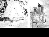 |
Avalanche tower and map | 1940; 1941; 1942; 1943; 1944; 1945; 1946; 1947; 1948; 1949; 1950; 1951; 1952; 1953; 1954; 1955; 1956; 1957; 1958; 1959; 1960; 1961; 1962; 1963; 1964; 1965; 1966; 1967; 1968; 1969 | Image | uum_map_usa |
| 2 |
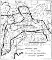 |
Boundary of Shoshone Indian Territory | 1957 | Image/StillImage | uaida_main |
| 3 |
 |
Boundary of Shoshone Indian Territory and Neighboring Tribes | 1957 | Image/StillImage | uaida_main |
| 4 |
 |
Boundary of Shoshone Indian Territory, showing the locations of the Bannock | 1957 | Image/StillImage | uaida_main |
| 5 |
 |
Boundary of Shoshone Indian Territory, showing the locations of the Bannock from 1819 to 1951 | 1957 | Image/StillImage | uaida_main |
| 6 |
 |
Boundary of Shoshone Indian Territory, showing the locations where the Bannock and Shoshone reported together 1819-1956 | 1957 | Image/StillImage | uaida_main |
| 7 |
 |
Boundary of Shoshone Indian Territory; Doty Map of 1863 Indian Claims Commission | 1957 | Image/StillImage | uaida_main |
| 8 |
 |
Naval Supply Depot, Clearfield P.20 | 1950; 1951; 1952; 1953; 1954; 1955; 1956; 1957; 1958; 1959; 1960; 1961; 1962; 1963 | Image/StillImage | dha_cp |