|
|
Title | Collection Number And Name | Photo Number |
| 1 |
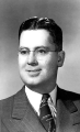 |
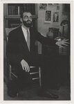
Gordon Miller, University of Utah faculty | P0305 University of Utah Archives Photograph Collection - A-Fa. | A-Fa.MillerGordon. |
| 2 |
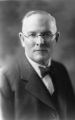 |
George Thomas, University of Utah president | P0305 University of Utah Archives Photograph Collection - A-Fa. Presidents | A-Fa.Thomas. |
| 3 |
 |
Junior Bounous holding an award. | P0004 Wasatch Mountain Club Photograph Collection | P0004n0017 |
| 4 |
 |
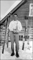
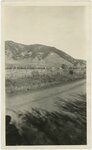
Leone (?) in southern Utah (?) | P0004 Wasatch Mountain Club Photograph Collection | P0004n16_06_016 |
| 5 |
 |
Alma Mater statue. University of Illinois Urbana-Champaign | P0004 Wasatch Mountain Club Photograph Collection | P0004n16_06_017 |
| 6 |
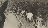 |
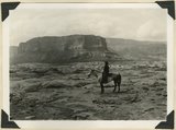
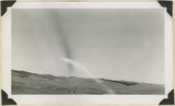
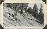
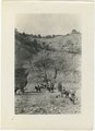
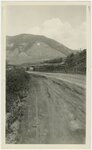
Pack horses on the trail | P0004 Wasatch Mountain Club Photograph Collection | P0004n16_09_002 |
| 7 |
 |
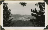
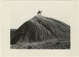
Fun spot of Utah | P0004 Wasatch Mountain Club Photograph Collection | P0004n18_177 |
| 8 |
 |
Hotel Penson Adler, Stans | P0004 Wasatch Mountain Club Photograph Collection | P0004n18_178 |
| 9 |
 |
Directions to China Town | P0004 Wasatch Mountain Club Photograph Collection | P0004n18_179 |
| 10 |
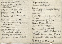 |
List of places photographed [01] | P0004 Wasatch Mountain Club Photograph Collection | P0004n18_180 |
| 11 |
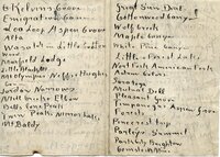 |
List of places photographed [02] | P0004 Wasatch Mountain Club Photograph Collection | P0004n18_181 |
| 12 |
 |
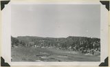
Wildwood, Provo Canyon [note] | P0004 Wasatch Mountain Club Photograph Collection | P0004n18_182 |
| 13 |
 |
List of places photographed [03] | P0004 Wasatch Mountain Club Photograph Collection | P0004n18_183 |
| 14 |
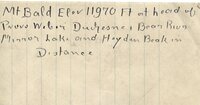 |
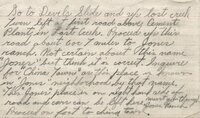
Mt. Bald (description of photo) | P0004 Wasatch Mountain Club Photograph Collection | P0004n18_184 |
| 15 |
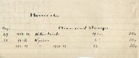 |
Harris & Co. (note) | P0004 Wasatch Mountain Club Photograph Collection | P0004n18_185 |
| 16 |
 |
Utah Opera Portraits | P0005 C. Lowell Lees Photograph Collection | P0005n02_03a_001 |
| 17 |
 |
Utah Opera Portraits, Portraits of Utah Opera People [01] | P0005 C. Lowell Lees Photograph Collection | P0005n02_03a_004 |
| 18 |
 |
Utah Opera Portraits, Portraits of Utah Opera People [02] | P0005 C. Lowell Lees Photograph Collection | P0005n02_03a_005 |
| 19 |
 |
Utah Opera Portraits, Portraits of Utah Opera People [03] | P0005 C. Lowell Lees Photograph Collection | P0005n02_03a_006 |
| 20 |
 |
Utah Opera Portraits, Portraits of Utah Opera People [04] | P0005 C. Lowell Lees Photograph Collection | P0005n02_03a_007 |
| 21 |
 |
Utah Opera Portraits, Portraits of Utah Opera People [05] | P0005 C. Lowell Lees Photograph Collection | P0005n02_03a_008 |
| 22 |
 |
Utah Opera Portraits, Portraits of Utah Opera People [06] | P0005 C. Lowell Lees Photograph Collection | P0005n02_03a_009 |
| 23 |
 |
Utah Opera Portraits, Portraits of Utah Opera People [07] | P0005 C. Lowell Lees Photograph Collection | P0005n02_03a_010 |
| 24 |
 |
Utah Opera Portraits, Portraits of Utah Opera People [08] | P0005 C. Lowell Lees Photograph Collection | P0005n02_03a_011 |
| 25 |
 |
Utah Opera Portraits, Portraits of Utah Opera People [09] | P0005 C. Lowell Lees Photograph Collection | P0005n02_03a_012 |
| 26 |
 |
Utah Opera Portraits, Portraits of Utah Opera People [10] | P0005 C. Lowell Lees Photograph Collection | P0005n02_03a_013 |
| 27 |
 |
Utah Opera Portraits, Portraits of Utah Opera People [11] | P0005 C. Lowell Lees Photograph Collection | P0005n02_03a_014 |
| 28 |
 |
Utah Opera Portraits, Portraits of Utah Opera People [12] | P0005 C. Lowell Lees Photograph Collection | P0005n02_03a_015 |
| 29 |
 |
Utah Opera Portraits, Portraits of Utah Opera People [13] | P0005 C. Lowell Lees Photograph Collection | P0005n02_03a_016 |
| 30 |
 |
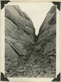
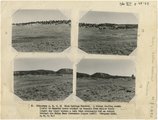
Utah Opera Portraits, Portraits of Utah Opera People [14] | P0005 C. Lowell Lees Photograph Collection | P0005n02_03a_017 |
| 31 |
 |
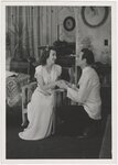
John Nicolaysen And Marion Foster, scene from George Kaufman's "You Can't Take It With You" performed at Kingsbury Hall, University of Utah, 1944 | P0005 C. Lowell Lees Photograph Collection | P0005n02_04_003 |
| 32 |
 |
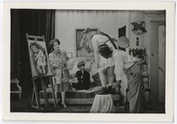
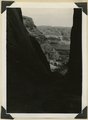
John Nicolaysen, scene from George Kaufman's "You Can't Take It With You" performed at Kingsbury Hall, University of Utah, 1944 | P0005 C. Lowell Lees Photograph Collection | P0005n02_04_004 |
| 33 |
 |
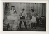
Norma Rae Lees and John Wolfe, scene from George Kaufman's "You Can't Take It With You" performed at Kingsbury Hall, University of Utah, 1944 [01] | P0005 C. Lowell Lees Photograph Collection | P0005n02_04_008 |
| 34 |
 |
Ralph Whitney (?) and Stanley Russon, scene from George Kaufman's "You Can't Take It With You" performed at Kingsbury Hall, University of Utah, 1944 | P0005 C. Lowell Lees Photograph Collection | P0005n02_04_012 |
| 35 |
 |
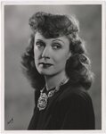
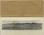
Publicity photograph of Judith Evelyn [01] | P0005 C. Lowell Lees Photograph Collection | P0005n02_11_013 |
| 36 |
 |
Publicity photograph of Judith Evelyn [02] | P0005 C. Lowell Lees Photograph Collection | P0005n02_11_014 |
| 37 |
 |
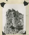
Publicity photograph of Judith Evelyn [03] | P0005 C. Lowell Lees Photograph Collection | P0005n02_11_016 |
| 38 |
 |
Publicity photograph of Judith Evelyn [04] | P0005 C. Lowell Lees Photograph Collection | P0005n02_11_017 |
| 39 |
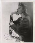 |
Autographed publicity photograph of Judith Evelyn | P0005 C. Lowell Lees Photograph Collection | P0005n02_11_018 |
| 40 |
 |
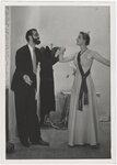
Virginia Webster, Joseph Bywater and unknow actress, scene from George Kaufman's "You Can't Take It With You" performed at Kingsbury Hall, University of Utah, 1944 | P0005 C. Lowell Lees Photograph Collection | P0005n02_12_018 |
| 41 |
 |
Scene from George Kaufman's "You Can't Take It With You" performed at Kingsbury Hall, University of Utah, 1944 [04] | P0005 C. Lowell Lees Photograph Collection | P0005n02_12_019 |
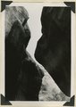
| 42 |
 |
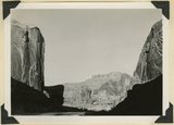
Norma Rae Lees and John Wolfe, scene from George Kaufman's "You Can't Take It With You" performed at Kingsbury Hall, University of Utah, 1944 [02] | P0005 C. Lowell Lees Photograph Collection | P0005n02_12_020 |
| 43 |
 |
Scene from George Kaufman's "You Can't Take It With You" performed at Kingsbury Hall, University of Utah, 1944 [05] | P0005 C. Lowell Lees Photograph Collection | P0005n02_12_021 |
| 44 |
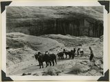
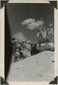
 |
Stanley Russon (grandpa), scene from George Kaufman's "You Can't Take It With You" performed at Kingsbury Hall, University of Utah, 1944 | P0005 C. Lowell Lees Photograph Collection | P0005n02_12_022 |
| 45 |
 |
Scene from George Kaufman's "You Can't Take It With You" performed at Kingsbury Hall, University of Utah, 1944 [06] | P0005 C. Lowell Lees Photograph Collection | P0005n02_12_023 |
| 46 |
 |
Scene from George Kaufman's "You Can't Take It With You" performed at Kingsbury Hall, University of Utah, 1944 [07] | P0005 C. Lowell Lees Photograph Collection | P0005n02_12_024 |
| 47 |
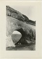
 |
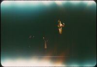
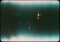
Two unidentified actors and Kay Nolte, scene from unidentified play | P0005 C. Lowell Lees Photograph Collection | P0005n02_19_004 |
| 48 |
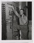 |
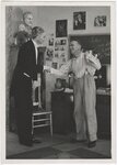
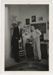
Ralph Margetts, main lighting switchboard at Kingsbury Hall, University of Utah | P0005 C. Lowell Lees Photograph Collection | P0005n02_21_006 |
| 49 |
 |
Women with Sempervivum tectorum (Hens and Chicks) in the shape of a beehive, Salt Lake City, Utah | P0005 C. Lowell Lees Photograph Collection | P0005n03_01_001 |
| 50 |
 |
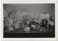
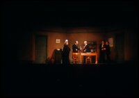
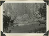
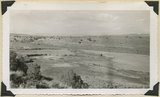
Stage set for unidentified play performed at Kingsbury Hall, University of Utah | P0005 C. Lowell Lees Photograph Collection | P0005n03_13_001 |
| 51 |
 |
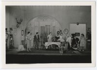
Scene from unidentified play performed at Kingsbury Hall, University of Utah [01] | P0005 C. Lowell Lees Photograph Collection | P0005n03_13_002 |
| 52 |
 |
Scene from unidentified play performed at Kingsbury Hall, University of Utah [02] | P0005 C. Lowell Lees Photograph Collection | P0005n03_13_003 |
| 53 |
 |
Scene from unidentified play performed at Kingsbury Hall, University of Utah [03] | P0005 C. Lowell Lees Photograph Collection | P0005n03_13_004 |
| 54 |
 |
Scene from unidentified play performed at Kingsbury Hall, University of Utah [04] | P0005 C. Lowell Lees Photograph Collection | P0005n03_13_005 |
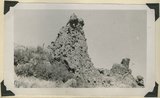
| 55 |
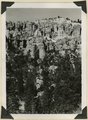
 |
Scene from unidentified play performed at Kingsbury Hall, University of Utah [05] | P0005 C. Lowell Lees Photograph Collection | P0005n03_13_006 |
| 56 |
 |
Scene from unidentified play performed at Kingsbury Hall, University of Utah [06] | P0005 C. Lowell Lees Photograph Collection | P0005n03_13_007 |
| 57 |
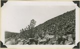
 |
Scene from unidentified play performed at Kingsbury Hall, University of Utah [07] | P0005 C. Lowell Lees Photograph Collection | P0005n03_13_008 |
| 58 |
 |
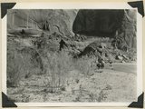
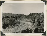
Scene from unidentified play, University of Utah [01] | P0005 C. Lowell Lees Photograph Collection | P0005n03_50_001 |
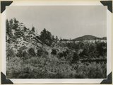
| 59 |
 |
Detail of a theatrical set from unidentified play, University of Utah | P0005 C. Lowell Lees Photograph Collection | P0005n03_50_002 |
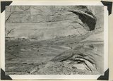
| 60 |
 |
Production photograph of unidentified ballet, University of Utah | P0005 C. Lowell Lees Photograph Collection | P0005n03_50_003 |
| 61 |
 |
Scene from unidentified play, University of Utah [02] | P0005 C. Lowell Lees Photograph Collection | P0005n03_50_004 |
| 62 |
 |
Scene from unidentified play, University of Utah [03] | P0005 C. Lowell Lees Photograph Collection | P0005n03_50_005 |
| 63 |
 |
Scene from unidentified play, University of Utah [04] | P0005 C. Lowell Lees Photograph Collection | P0005n03_50_006 |
| 64 |
 |
Scene from unidentified play, University of Utah [05] | P0005 C. Lowell Lees Photograph Collection | P0005n03_50_007 |
| 65 |
 |
Scene from unidentified play, University of Utah [06] | P0005 C. Lowell Lees Photograph Collection | P0005n03_50_008 |
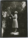
| 66 |
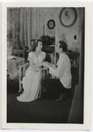
 |
Scene from unidentified play, University of Utah [07] | P0005 C. Lowell Lees Photograph Collection | P0005n03_50_009 |
| 67 |
 |
Scene from unidentified play, University of Utah [08] | P0005 C. Lowell Lees Photograph Collection | P0005n03_50_010 |
| 68 |
 |
Scene from unidentified play, University of Utah [09] | P0005 C. Lowell Lees Photograph Collection | P0005n03_50_011 |
| 69 |
 |
Scene from unidentified play, University of Utah [10] | P0005 C. Lowell Lees Photograph Collection | P0005n03_50_012 |
| 70 |
 |
Scene from unidentified play, University of Utah [11] | P0005 C. Lowell Lees Photograph Collection | P0005n03_50_013 |
| 71 |
 |
Scene from unidentified play, University of Utah [12] | P0005 C. Lowell Lees Photograph Collection | P0005n03_50_014 |
| 72 |
 |
Scene from unidentified play, University of Utah [13] | P0005 C. Lowell Lees Photograph Collection | P0005n03_50_015 |
| 73 |
 |
C. Lowell Lees family [02] | P0005 C. Lowell Lees Photograph Collection | P0005n06_03_004 |
| 74 |
 |
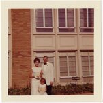
C. Lowell Lees family [03] | P0005 C. Lowell Lees Photograph Collection | P0005n06_03_005 |
| 75 |
 |
Salt Lake temple postcard | P0005 C. Lowell Lees Photograph Collection | P0005n06_12_002 |
| 76 |
 |
Demolition of unidentified building | P0005 C. Lowell Lees Photograph Collection | P0005n06_13_001 |
| 77 |
 |
Unidentified actress and actor | P0005 C. Lowell Lees Photograph Collection | P0005n06_20_001 |
| 78 |
 |
Unidentified actress and actor in costume for unidentified Utah theatrical production | P0005 C. Lowell Lees Photograph Collection | P0005n06_23_014 |
| 79 |
 |
Unidentified actress in costume for unidentified Utah theatrical production | P0005 C. Lowell Lees Photograph Collection | P0005n06_23_017 |
| 80 |
 |
Lees Family [01] | P0005 C. Lowell Lees Photograph Collection | P0005n06_25_001 |
| 81 |
 |
Lees Family [02] | P0005 C. Lowell Lees Photograph Collection | P0005n06_25_002 |
| 82 |
 |
Lees Family [03] | P0005 C. Lowell Lees Photograph Collection | P0005n06_25_003 |
| 83 |
 |
Lees Family [04] | P0005 C. Lowell Lees Photograph Collection | P0005n06_25_004 tif; P0005n06_25_004b.tif |
| 84 |
 |
Lees Family [05] | P0005 C. Lowell Lees Photograph Collection | P0005n06_25_005 |
| 85 |
 |
Lees Family [06] | P0005 C. Lowell Lees Photograph Collection | P0005n06_25_006 |
| 86 |
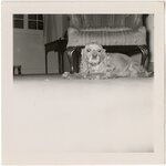 |
Dog [01] | P0005 C. Lowell Lees Photograph Collection | P0005n06_25_009 |
| 87 |
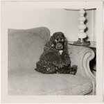 |
Dog [02] | P0005 C. Lowell Lees Photograph Collection | P0005n06_25_010 |
| 88 |
 |
Lees Family [09] | P0005 C. Lowell Lees Photograph Collection | P0005n06_25_011 |
| 89 |
 |
Lees Family [11] | P0005 C. Lowell Lees Photograph Collection | P0005n06_25_014 |
| 90 |
 |
Herbert E. Gregory Book 12: Colorado Plateau, Province, 1942-1944 | P0013 Herbert E. Gregory Photograph Collection | P0013n12 |
| 91 |
 |
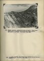
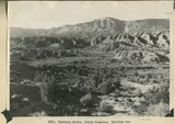
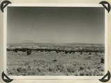
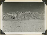
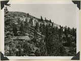
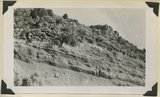
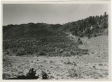
Vermillion Cliffs. Chinle formation. Petrified Forest member (foreground and basalt slopes) and upper sandstone. Flag Point, Kane County, UT. 1944 | P0013 Herbert E. Gregory Photograph Collection | P0013n12_031_2879 |
| 92 |
 |
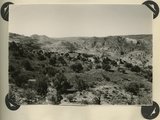
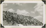
West wall of Seaman Wash | P0013 Herbert E. Gregory Photograph Collection | P0013n12_032_2880 |
| 93 |
 |
West wall of Seaman Wash | P0013 Herbert E. Gregory Photograph Collection | P0013n12_032_2880 |
| 94 |
 |
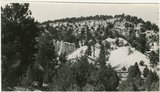
Vermillion Cliffs. Chinle formation. Petrified Forest member eroded into bedlands; upper sandstone capped by outliers of Wingate. Lower Road Creek. Kane County, UT, 1944 | P0013 Herbert E. Gregory Photograph Collection | P0013n12_033_2881 |
| 95 |
 |
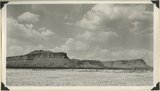
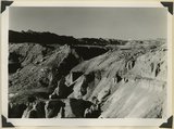
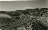
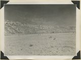
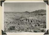
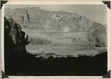
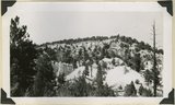
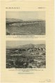
Looking southward across House Rock Valley from West Clark Bench. West dipping Navajo sandstone trenched by Kaibab Creek (middle distance) is a part of the East Kaibab monocline; east dipping limestones (skyline) are the cap rocks of the Kaibab upwarp. Kane County, UT, 1944 | P0013 Herbert E. Gregory Photograph Collection | P0013n12_035_2882 |
| 96 |
 |
Looking south, up dip, across West Clark Bench, Upper Jurassic and Dakota (butte), to the Paria Terrace, Navajo sandstone. Paria River, which passes through 'The Gap' is joined by Kaibab Creek. Kane County, UT. 1944 | P0013 Herbert E. Gregory Photograph Collection | P0013n12_036_2883 |
| 97 |
 |
Looking south, up dip, across West Clark Bench, Upper Jurassic and Dakota (butte), to the Paria Terrace, Navajo sandstone. Paria River, which passes through 'The Gap' is joined by Kaibab Creek. Kane County, UT. 1944 | P0013 Herbert E. Gregory Photograph Collection | P0013n12_036_2883 |
| 98 |
 |
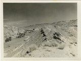
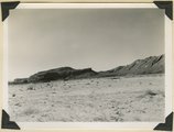
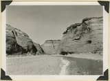
Looking east across Paria River Canyon where it separates West and East Clark Benches. Upper Jurassic (foreground) and Navajo (background) dip northeast. Navajo Mountain and Kaiparowits Plateau are on opposite sides of Glen Canyon. Kane County, UT. 1944 | P0013 Herbert E. Gregory Photograph Collection | P0013n12_037_2884 |
| 99 |
 |
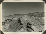
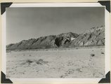
Looking south (up dip) down the Paria River, which has widened its floor and dissected its borders in Upper Jurassic rocks (foreground) and cut a deep narrow canyon in the Navajo sandstone (background). Site of the abandoned Adairville. Kane County UT, 1944 | P0013 Herbert E. Gregory Photograph Collection | P0013n12_038_2885 |
| 100 |
 |
Looking south (up dip) down the Paria River, which has widened its floor and dissected its borders in Upper Jurassic rocks (foreground) and cut a deep narrow canyon in the Navajo sandstone (background). Site of the abandoned Adairville. Kane County UT, 1944 | P0013 Herbert E. Gregory Photograph Collection | P0013n12_038_2885 |
| 101 |
 |
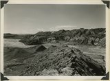
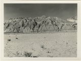
Flat lying Upper Jurassic (foreground) and Cretaceous strata bed abruptly upward against the Navajo on the flank of the East Kaibab monocline (left sky line). Table Cliffs (right sky line) is about 50 miles north. Paria Valley near Adairville. Kane County, UT. 1944 | P0013 Herbert E. Gregory Photograph Collection | P0013n12_039_2886 |
| 102 |
 |
Flat lying Upper Jurassic (foreground) and Cretaceous strata bed abruptly upward against the Navajo on the flank of the East Kaibab monocline (left sky line). Table Cliffs (right sky line) is about 50 miles north. Paria Valley near Adairville. Kane County, UT. 1944 | P0013 Herbert E. Gregory Photograph Collection | P0013n12_039_2886 |
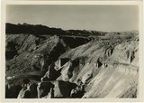
| 103 |
 |
Eroded flank of the East Kaibab monocline at the junction of Paria River and Cottonwood Creek (left center). The sequence is Navajo (left), upper Jurassic (largely eroded), Dakota, Tropic, and Straight Cliffs. Kane County, UT, 1944 | P0013 Herbert E. Gregory Photograph Collection | P0013n12_040_2887 |
| 104 |
 |
Eroded flank of the East Kaibab monocline at the junction of Paria River and Cottonwood Creek (left center). The sequence is Navajo (left), upper Jurassic (largely eroded), Dakota, Tropic, and Straight Cliffs. Kane County, UT, 1944 | P0013 Herbert E. Gregory Photograph Collection | P0013n12_040_2887 |
| 105 |
 |
Looking south along Paria River from the mouth of Shurtz Gorge. Navajo sandstone in East Kaibab monocline is overlaid with decreasing dips by Upper Jurassic (banked against the Navajo), Dakota, and Tropic (foreground and left sky line). Erosion surface (middle distance) bevels upturned rocks. Kane County, UT, 1944 | P0013 Herbert E. Gregory Photograph Collection | P0013n12_041_2888 |
| 106 |
 |
Looking south along Paria River from the mouth of Shurtz Gorge. Navajo sandstone in East Kaibab monocline is overlaid with decreasing dips by Upper Jurassic (banked against the Navajo), Dakota, and Tropic (foreground and left sky line). Erosion surface (middle distance) bevels upturned rocks. Kane County, UT, 1944 | P0013 Herbert E. Gregory Photograph Collection | P0013n12_041_2888 |
| 107 |
 |
Panorama {a}. Flank of East Kaibab monocline, bordering alluvial floor of Paria Valley. Navajo sandstone (middle sky line), Upper Jurassic strata, and basal Cretaceous (left). Dips of 40 degrees decrease to 3 degrees within 1,000 feet. Kane County, UT, 1944 | P0013 Herbert E. Gregory Photograph Collection | P0013n12_042_2889 |
| 108 |
 |
Panorama {b}. Flank of East Kaibab monocline, bordering alluvial floor of Paria Valley. Navajo sandstone (middle sky line), Upper Jurassic strata, and basal Cretaceous (left). Dips of 40 degrees decrease to 3 degrees within 1,000 feet. Kane County, UT, 1944 | P0013 Herbert E. Gregory Photograph Collection | P0013n12_042_2890 |
| 109 |
 |
Panorama {c}. Flank of East Kaibab monocline, bordering alluvial floor of Paria Valley. Navajo sandstone (middle sky line), Upper Jurassic strata, and basal Cretaceous (left). Dips of 40 degrees decrease to 3 degrees within 1,000 feet. Kane County, UT, 1944 | P0013 Herbert E. Gregory Photograph Collection | P0013n12_042_2891 |
| 110 |
 |
Panorama {c}. Flank of East Kaibab monocline, bordering alluvial floor of Paria Valley. Navajo sandstone (middle sky line), Upper Jurassic strata, and basal Cretaceous (left). Dips of 40 degrees decrease to 3 degrees within 1,000 feet. Kane County, UT, 1944 | P0013 Herbert E. Gregory Photograph Collection | P0013n12_042_2891 |
| 111 |
 |
Panorama {d}. Flank of East Kaibab monocline, bordering alluvial floor of Paria Valley. Navajo sandstone (middle sky line), Upper Jurassic strata, and basal Cretaceous (left). Dips of 40 degrees decrease to 3 degrees within 1,000 feet. Kane County, UT, 1944 | P0013 Herbert E. Gregory Photograph Collection | P0013n12_043_2892 |
| 112 |
 |
Panorama {e}. Flank of East Kaibab monocline, bordering alluvial floor of Paria Valley. Navajo sandstone (middle sky line), Upper Jurassic strata, and basal Cretaceous (left). Dips of 40 degrees decrease to 3 degrees within 1,000 feet. Kane County, UT, 1944 | P0013 Herbert E. Gregory Photograph Collection | P0013n12_043_2893 |
| 113 |
 |
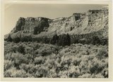
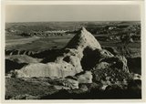
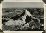
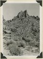
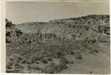
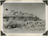
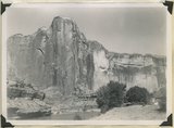
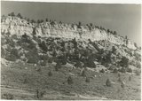
Pinnacles of Navajo sandstone in House Rock Valley along the course of Kaibab Creek. Eroded part of East Kaibab monocline. Kane County, UT, 1944 | P0013 Herbert E. Gregory Photograph Collection | P0013n12_044_2894 |
| 114 |
 |
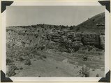
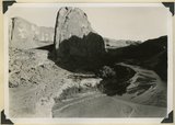
Gap cut in Navajo sandstone by Kaibab Creek where it leaves its structural valley to cross East Kaibab monocline. Northward through the gap House Rock Valley and Kaibab Plateau are visible. Kane County, UT. 1944 | P0013 Herbert E. Gregory Photograph Collection | P0013n12_044_2895 |
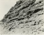
| 115 |
 |
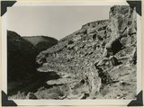
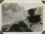
Joints and small faults in Navajo sandstone along the crest (Coxcomb) of East Kaibab monocline. Kane County, UT, 1944 | P0013 Herbert E. Gregory Photograph Collection | P0013n12_045_2896 |
| 116 |
 |
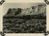
Paria River below White Rock Spring. Wall of Navajo sandstone capped by Carmel formation. Kane County, UT, 1944 | P0013 Herbert E. Gregory Photograph Collection | P0013n12_046_2897 |
| 117 |
 |
Paria river below White Rock Spring. Wall of Navajo sandstone capped by Carmel formation. Upper Jurassic rocks on right sky line. Kane County, UT, 1944 | P0013 Herbert E. Gregory Photograph Collection | P0013n12_046_2898 |
| 118 |
 |
Kaibab limestone (lower wall,left, breccia (marks unconformable contact), and basal Moenkopi limestone and shales. Mouth of Kaibab Gulch. Kane County, UT, 1944 | P0013 Herbert E. Gregory Photograph Collection | P0013n12_047-048_2899 |
| 119 |
 |
Kaibab limestone (lower wall,left, breccia (marks unconformable contact), and basal Moenkopi limestone and shales. Mouth of Kaibab Gulch. Kane County, UT, 1944 | P0013 Herbert E. Gregory Photograph Collection | P0013n12_047_2899 |
| 120 |
 |
Permian limestones (Kaibab) overlain by the Triassic Moenkopi. Head of Kaibab Gulch, along Kanab-Paria road. Kane County, UT, 1944 | P0013 Herbert E. Gregory Photograph Collection | P0013n12_049_2900 |
| 121 |
 |
Timpoweap member of the Moenkopi formation. Kaibab at base, upstream. East rim of the Kaibab Plateau near the UT-AZ line. Coconino County, AZ, 1944 | P0013 Herbert E. Gregory Photograph Collection | P0013n12_049_2901 |
| 122 |
 |
View looking east from Kaibab Plateau across House Rock Valley (invisible) to the Coxcomb Navajo sandstone in the East Kaibab monocline. Timpoweap member of the Moenkopi forms walls of local gulch. Kane County, UT, 1944 | P0013 Herbert E. Gregory Photograph Collection | P0013n12_050_2902 |
| 123 |
 |
Shinarump Conglomerate at Pioneer Gap. Kane County, UT, 1944 | P0013 Herbert E. Gregory Photograph Collection | P0013n12_050_2903 |
| 124 |
 |
Mesa capped by Dakota sandstone eroded from upper Jurassic Winsor (?) formation. Head of Ash Creek. Kane County, UT | P0013 Herbert E. Gregory Photograph Collection | P0013n12_051_2903A |
| 125 |
 |
Section of the Shinarump Cliffs (middle distance), east of Pioneer Gap. Shinarump conglomerate exposed by erosion of Moenkopi formation below and the basal strata of the Chinle formation above. Upper Chinle sandstones form Vermilion Cliffs (background). | P0013 Herbert E. Gregory Photograph Collection | P0013n12_052B |
| 126 |
 |
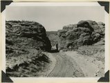
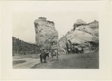
West entrance to Hole-in-the-Rock, an eroded fault crack in Navajo sandstone on the west rim of Glen Canyon. A feature of the abandoned Escalante-Bluff Road. Garfield County, UT, 1944 | P0013 Herbert E. Gregory Photograph Collection | P0013n12_054_2904 |
| 127 |
 |
West entrance to Hole-in-the-Rock, an eroded fault crack in Navajo sandstone on the west rim of Glen Canyon. A feature of the abandoned Escalante-Bluff Road. Garfield County, UT, 1944 | P0013 Herbert E. Gregory Photograph Collection | P0013n12_054_2905 |
| 128 |
 |
Looking east across Glen Canyon from east entrance to Hole-in-the-Rock. Navajo sandstone (foreground and skyline), below it Kayenta and Wingate. Garfield County, UT, 1944 | P0013 Herbert E. Gregory Photograph Collection | P0013n12_055_2906 |
| 129 |
 |
Head of Break Neck Trail down the south wall of Escalante Canyon (middle distance). Navajo sandstone. Garfield County, UT, 1944 | P0013 Herbert E. Gregory Photograph Collection | P0013n12_055_2907 |
| 130 |
 |
Escalante Canyon 2 miles below Big Bend. Walls of Navajo sandstone 800 feet high. Garfield, UT, 1944 | P0013 Herbert E. Gregory Photograph Collection | P0013n12_056_2908 |
| 131 |
 |
Escalante Canyon down stream from Big Bend. Garfield County, UT, 1944 | P0013 Herbert E. Gregory Photograph Collection | P0013n12_056_2909 |
| 132 |
 |
Escalante Canyon, cliff cave 3 miles above Cave Camp. Garfield County, UT, 1944 | P0013 Herbert E. Gregory Photograph Collection | P0013n12_057_2910 |
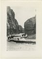
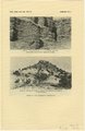
| 133 |
 |
Escalante Canyon. Pueblo ruins in cliff cave. Navajo sandstone. Scale shown by horse. Garfield County, UT, 1944 | P0013 Herbert E. Gregory Photograph Collection | P0013n12_057_2911 |
| 134 |
 |
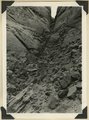
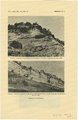
Willow Creek branch of Escalante Canyon. Entrance to 'the Narrows,' 400 feet long and 5-6 feet wide; perched log marks high water stage. Garfield County, UT, 1944 | P0013 Herbert E. Gregory Photograph Collection | P0013n12_058_2912 |
| 135 |
 |
Willow Creek branch of Escalante Canyon. In sinking its channel the creek has been guided by joints in Navajo sandstone. Garfield County, UT, 1944 | P0013 Herbert E. Gregory Photograph Collection | P0013n12_058_2913 |
| 136 |
 |
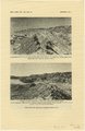
Escalante Canyon. Sheer wall of Navajo sandstone 840 feet high. Garfield County, UT, 1944 | P0013 Herbert E. Gregory Photograph Collection | P0013n12_059_2914 |
| 137 |
 |
Escalante Canyon walls of Navajo sandstone at Big Bend camp. Moonlight view. Garfield County, UT, 1944 | P0013 Herbert E. Gregory Photograph Collection | P0013n12_059_2915 |
| 138 |
 |
Escalante River at Big Bend, flowing west. After surrounding the tower of Navajo sandstone (center), the river comes within 300 feet of its east flowing section at the base of the wall (upper left). Garfield County, UT, 1944 | P0013 Herbert E. Gregory Photograph Collection | P0013n12_060_2916 |
| 139 |
 |
Escalante River at Big Bend, flowing east. At times of high water the stream flows across Kayenta formation at the meander neck (lower right). Garfield County, UT, 1944 | P0013 Herbert E. Gregory Photograph Collection | P0013n12_061_2917 |
| 140 |
 |
Surface of Navajo sandstone trenched by Escalante Canyon (right middle). Aquarius Plateau on skyline. Garfield County, UT, 1944 | P0013 Herbert E. Gregory Photograph Collection | P0013n12_062_2918 |
| 141 |
 |
Surface of Navajo sandstone between Escalante Canyon and Kaiparowits Plateau. Butte of Upper Jurassic rocks. Near head of Davis Creek. Garfield County, UT, 1944 | P0013 Herbert E. Gregory Photograph Collection | P0013n12_062_2919 |
| 142 |
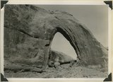 |
Gothic Arch. Width 174 feet, estimated height 190 feet. End of a buttress of Navajo sandstone resting on Kayenta. Soda Creek branch of Escalante River. Garfield County, UT, 1944 | P0013 Herbert E. Gregory Photograph Collection | P0013n12_063_2920 |
| 143 |
 |
Natural bridge of Navajo sandstone. Span 85 feet, height to girder 76 feet. Willow Creek. Garfield County, UT, 1944 | P0013 Herbert E. Gregory Photograph Collection | P0013n12_064_2921 |
| 144 |
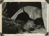 |
Natural bridge of Navajo sandstone. Span 85 feet, height to girder 76 feet. Willow Creek. Garfield County, UT, 1944 | P0013 Herbert E. Gregory Photograph Collection | P0013n12_064_2922 |
| 145 |
 |
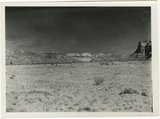
Looking west across Panguitch. Sevier River formation (foreground), alluvium (middle distance), basalt (left center), and pyroclastic slopes leading to Little Creek Peak (background), on the east wall of Bear Valley. Garfield County, UT, 1944 | P0013 Herbert E. Gregory Photograph Collection | P0013n12_065_2923 |
| 146 |
 |
Looking northwest across Horse Lake Valley. Basalt (foreground), Pyroclastics (background). Garfield County, UT, 1944 | P0013 Herbert E. Gregory Photograph Collection | P0013n12_066_2924 |
| 147 |
 |
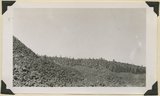
Treeless slope developed on pyroclastic and igneous rocks typical of areas west of Panguitch Creek. Garfield County, UT, 1944 | P0013 Herbert E. Gregory Photograph Collection | P0013n12_066_2925 |
| 148 |
 |
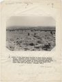
South Fork of Sevier River below mouth of Asay Creek. Garfield County, UT, 1944 | P0013 Herbert E. Gregory Photograph Collection | P0013n12_067_2926 |
| 149 |
 |
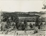
Lower Castle Creek Valley; broad floor of low gradient developed in Brian Head formation. Garfield County, UT, 1944 | P0013 Herbert E. Gregory Photograph Collection | P0013n12_067_2927 |
| 150 |
 |
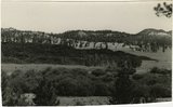
(Panorama A, B, C, D) Blue Springs Meadows. A stream leading south (left) to Mammoth Creek blocked by basalts from Miller Knoll (right sky line) became a lake that eventuallly cut an outlet through the Brian Head formation (upper left). | P0013 Herbert E. Gregory Photograph Collection | P0013n12_068-069_2929ABCD |
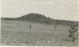
| 151 |
 |
Panorama--4 photographs. Blue Springs meadows. A former valley leading to Mammoth Creek blocked by basalts from Miller Knoll (right skyline) became a lake that eventually cut an outlet northward through the Brian Head formation (upper left). Garfield County, UT, 1944 | P0013 Herbert E. Gregory Photograph Collection | P0013n12_068-069_pan |
| 152 |
 |
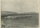
Blue Springs meadow at Leigh ranch. Stream from big springs (lower left) meanders across an ancient lake bed and escapes through a water gap (center distance). Garfield County, UT, 1944 | P0013 Herbert E. Gregory Photograph Collection | P0013n12_068_2928 |
| 153 |
 |
Panorama (a): Blue Springs meadows. A former valley leading to Mammoth Creek blocked by basalts from Miller Knoll (right skyline) became a lake that eventually cut an outlet northward through the Brian Head formation (upper left). Garfield County, UT, 1944 | P0013 Herbert E. Gregory Photograph Collection | P0013n12_068_2929A |
| 154 |
 |
Panorama (b): Blue Springs meadows. A former valley leading to Mammoth Creek blocked by basalts from Miller Knoll (right skyline) became a lake that eventually cut an outlet northward through the Brian Head formation (upper left). Garfield County, UT, 1944 | P0013 Herbert E. Gregory Photograph Collection | P0013n12_069_2929B |
| 155 |
 |
Panorama (c): Blue Springs meadows. A former valley leading to Mammoth Creek blocked by basalts from Miller Knoll (right skyline) became a lake that eventually cut an outlet northward through the Brian Head formation (upper left). Garfield County, UT, 1944 | P0013 Herbert E. Gregory Photograph Collection | P0013n12_069_2929C |
| 156 |
 |
Panorama (d): Blue Springs meadows. A former valley leading to Mammoth Creek blocked by basalts from Miller Knoll (right skyline) became a lake that eventually cut an outlet northward through the Brian Head formation (upper left). Garfield County, UT, 1944 | P0013 Herbert E. Gregory Photograph Collection | P0013n12_069_2929D |
| 157 |
 |
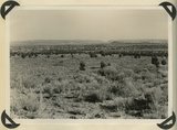
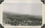
Sheep Flat. Broad treeless highland crossed by shallow stream runways between Coalpits Wash and Pinion Ridge. A little modified part of the eastward dipping (right) surface of Markagunt Plateau. Garfield County, UT, 1944 | P0013 Herbert E. Gregory Photograph Collection | P0013n12_070_2930 |
| 158 |
 |
Wasatch limestones, overlying Cretaceous; southern limit of Pink Cliffs. Dairy Canyon. Kane County, UT, 1944 | P0013 Herbert E. Gregory Photograph Collection | P0013n12_070_2931 |
| 159 |
 |
Brian Head formation, consolidated (white wall) and disintegrated (upper slopes), and pink Wasatch limestones (lowest slopes). Seamans Canyon west of Gravel Pass. Kane County, UT, 1944 | P0013 Herbert E. Gregory Photograph Collection | P0013n12_071_2932 |
| 160 |
 |
Brian Head formation, consolidated (white wall) and disintegrated (upper slopes), and pink Wasatch limestones (lowest slopes). Seamans Canyon west of Gravel Pass. Kane County, UT, 1944 | P0013 Herbert E. Gregory Photograph Collection | P0013n12_071_2933 |
| 161 |
 |
Brian Head formation underlain by pink Wasatch limestone on Highway 89, 2± miles north of Castle Creek. Garfield County, UT, 1944 | P0013 Herbert E. Gregory Photograph Collection | P0013n12_072_2934 |
| 162 |
 |
Brian Head formation, branch of Asay Creek; lies beneath basalt flows. Garfield County, UT, 1944 | P0013 Herbert E. Gregory Photograph Collection | P0013n12_072_2935 |
| 163 |
 |
Brian Head formation, branch of Asay Creek; lies beneath basalt flows. Garfield County, UT, 1944 | P0013 Herbert E. Gregory Photograph Collection | P0013n12_072_2935 |
| 164 |
 |
Typical outcrop of conglomerate near base of Brian Head formation, Castle Creek. Garfield County, UT, 1944 | P0013 Herbert E. Gregory Photograph Collection | P0013n12_073_2936 |
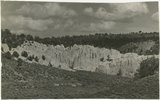
| 165 |
 |
Brian Head formation at the 'Castles,' Castle Creek. Garfield County, UT, 1944 | P0013 Herbert E. Gregory Photograph Collection | P0013n12_073_2937 |
| 166 |
 |
Brian Head formation at the 'Castles,' Castle Creek. Garfield County, UT, 1944. Details of erosion | P0013 Herbert E. Gregory Photograph Collection | P0013n12_074_2938 |
| 167 |
 |
Igneous breccia in Brian Head formation(?), upper Panguitch Creek. Garfield County, UT, 1944 | P0013 Herbert E. Gregory Photograph Collection | P0013n12_074_2939 |
| 168 |
 |
Sevier River formation overlaid by basalt near mouth of Corral Creek on highway 89. Garfield County, Utah, 1944 | P0013 Herbert E. Gregory Photograph Collection | P0013n12_075_2940 |
| 169 |
 |
Sevier River formation overlaid by basalt near mouth of Corral Creek on Highway 89, 2 miles east of Panguitch. Garfield County, UT. 1944 | P0013 Herbert E. Gregory Photograph Collection | P0013n12_075_2940A |
| 170 |
 |
Bowers Knoll; Volcano viewed from northwest. Garfield County, UT. 1944 | P0013 Herbert E. Gregory Photograph Collection | P0013n12_076_2940B |
| 171 |
 |
Basalt, head of Rock Creek. Old lava (foreground) and end of newer flow (center). Garfield County, UT, 1944 | P0013 Herbert E. Gregory Photograph Collection | P0013n12_077_2941 |
| 172 |
 |
End of basalt flow in Black Rock Valley. White rocks (foreground) and left sky line (Haycock Mountain) of Brian Head formation. Garfield County, UT, 1944 | P0013 Herbert E. Gregory Photograph Collection | P0013n12_077_2942 |
| 173 |
 |
End of basalt flow in Black Rock Valley. White rocks (foreground) and left sky line (Haycock Mountain) of Brian Head formation. Garfield County, UT, 1944 | P0013 Herbert E. Gregory Photograph Collection | P0013n12_078_2943 |
| 174 |
 |
Wagon Wheel Gap, Rock Creek Canyon. Walls of basalt, 120 feet high. Garfield County, UT, 1944 | P0013 Herbert E. Gregory Photograph Collection | P0013n12_078_2944 |
| 175 |
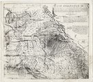 |
Plano geografico de la tierra descubierta y demarcada por Dn. Bernardo de Miera y Paceco al Yumbo del noroeste y oest del Nuevo Mexico, quien fue en compania de los R.R.s P.Ps. Fs. Fran.co Atanacio Dominguez... y Fr. Silvestre Velez de Escalante | P0013 Herbert E. Gregory Photograph Collection | P0013n16_09_04 |
| 176 |
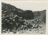 |
Hillside of eroded rock, Paria Valley, Utah | P0013 Herbert E. Gregory Photograph Collection | P0013n16_12_01 |
| 177 |
 |
Road and lava field, Rock Creek Valley, Utah | P0013 Herbert E. Gregory Photograph Collection | P0013n16_12_02 |
| 178 |
 |
Rocky cliff near Hillsdale | P0013 Herbert E. Gregory Photograph Collection | P0013n16_12_03 |
| 179 |
 |
Lava, Black Rock Valley | P0013 Herbert E. Gregory Photograph Collection | P0013n16_12_04 |
| 180 |
 |
Paria Valley and east flank of East Kaibab monocline | P0013 Herbert E. Gregory Photograph Collection | P0013n16_12_05 |
| 181 |
 |
Mound of sedimentary material, vicinity of Paria River, Utah | P0013 Herbert E. Gregory Photograph Collection | P0013n16_12_06 |
| 182 |
 |
Sandstone outcrops, Paria Canyon, Utah | P0013 Herbert E. Gregory Photograph Collection | P0013n16_12_07 |
| 183 |
 |
Paria Canyon, Utah | P0013 Herbert E. Gregory Photograph Collection | P0013n16_12_08 |
| 184 |
 |
White rocks on road to Panquitch, Utah | P0013 Herbert E. Gregory Photograph Collection | P0013n16_12_09 |
| 185 |
 |
East side of Lone Rock on Wah Weap Creek | P0013 Herbert E. Gregory Photograph Collection | P0013n16_12_10 |
| 186 |
 |
Upper Box in Paria Canyon just south of Cannonville | P0013 Herbert E. Gregory Photograph Collection | P0013n16_12_11 |
| 187 |
 |
End of lava flow 6 miles long in Black Creek Valley | P0013 Herbert E. Gregory Photograph Collection | P0013n16_12_12 |
| 188 |
 |
White cliffs along highway south of Asay Creek, Brian Head formation | P0013 Herbert E. Gregory Photograph Collection | P0013n16_12_13 |
| 189 |
 |
Views along Vermilion Cliffs [and] Permian and Triassic rocks at the mouth of Limestone Gulch | P0013 Herbert E. Gregory Photograph Collection | P0013n16_12_14 |
| 190 |
 |
Views of the Moenkopi Formation [and] Triassic rocks | P0013 Herbert E. Gregory Photograph Collection | P0013n16_12_15 |
| 191 |
 |
Wingate Sandstone [and] Features of Jurassic and recent formation | P0013 Herbert E. Gregory Photograph Collection | P0013n16_12_16 |
| 192 |
 |
Features of the East Kaibab monocline [and] Structural relations of rocks along Utah-Arizona boundary | P0013 Herbert E. Gregory Photograph Collection | P0013n16_12_17 |
| 193 |
 |
Montana State University, Bozeman Montana [01] | P0029 Joseph Kingsbury Photograph Collection | P0029n01_06_02 |
| 194 |
 |
Montana State University, Bozeman Montana [02] | P0029 Joseph Kingsbury Photograph Collection | P0029n01_06_03 |
| 195 |
 |
Paragonah, Utah, home of Eliza Edwards Hanks [02] | P0029 Joseph Kingsbury Photograph Collection | P0029n01_06_06 |
| 196 |
 |
Hanks (on envelope) [02] | P0029 Joseph Kingsbury Photograph Collection | P0029n01_07_22 |
| 197 |
 |
Portrait of LeRoy Robertson [01] | P0038 LeRoy Robertson photograph collection, 1945-1960 | P0038n01_01_001 |
| 198 |
 |
Ruth Harwood standing on stool admiring a plant | P0042 Ruth Harwood Photograph Collection, Circa 1900-1950 | P0042n01_01_007 |
| 199 |
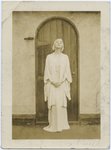 |
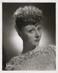
Ruth St. Denis in white gown standing in front of wooden door | P0042 Ruth Harwood Photograph Collection, Circa 1900-1950 | P0042n01_02_016 |
| 200 |
 |
Autographed portrait of Ruth St. Denis [1] | P0042 Ruth Harwood Photograph Collection, Circa 1900-1950 | P0042n01_02_017 |