|
|
Title | Collection Number And Name | Photo Number |
| 26 |
 |
Timpoweap member of the Moenkopi formation. Kaibab at base, upstream. East rim of the Kaibab Plateau near the UT-AZ line. Coconino County, AZ, 1944 | P0013 Herbert E. Gregory Photograph Collection | P0013n12_049_2901 |
| 27 |
 |
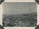
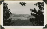
View looking east from Kaibab Plateau across House Rock Valley (invisible) to the Coxcomb Navajo sandstone in the East Kaibab monocline. Timpoweap member of the Moenkopi forms walls of local gulch. Kane County, UT, 1944 | P0013 Herbert E. Gregory Photograph Collection | P0013n12_050_2902 |
| 28 |
 |
Shinarump Conglomerate at Pioneer Gap. Kane County, UT, 1944 | P0013 Herbert E. Gregory Photograph Collection | P0013n12_050_2903 |
| 29 |
 |
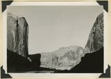
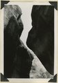
West entrance to Hole-in-the-Rock, an eroded fault crack in Navajo sandstone on the west rim of Glen Canyon. A feature of the abandoned Escalante-Bluff Road. Garfield County, UT, 1944 | P0013 Herbert E. Gregory Photograph Collection | P0013n12_054_2904 |
| 30 |
 |
West entrance to Hole-in-the-Rock, an eroded fault crack in Navajo sandstone on the west rim of Glen Canyon. A feature of the abandoned Escalante-Bluff Road. Garfield County, UT, 1944 | P0013 Herbert E. Gregory Photograph Collection | P0013n12_054_2905 |
| 31 |
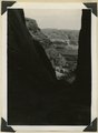 |
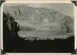
Looking east across Glen Canyon from east entrance to Hole-in-the-Rock. Navajo sandstone (foreground and skyline), below it Kayenta and Wingate. Garfield County, UT, 1944 | P0013 Herbert E. Gregory Photograph Collection | P0013n12_055_2906 |
| 32 |
 |
Head of Break Neck Trail down the south wall of Escalante Canyon (middle distance). Navajo sandstone. Garfield County, UT, 1944 | P0013 Herbert E. Gregory Photograph Collection | P0013n12_055_2907 |
| 33 |
 |
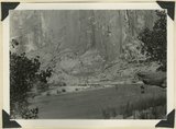
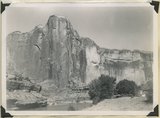
Escalante Canyon 2 miles below Big Bend. Walls of Navajo sandstone 800 feet high. Garfield, UT, 1944 | P0013 Herbert E. Gregory Photograph Collection | P0013n12_056_2908 |
| 34 |
 |
Escalante Canyon down stream from Big Bend. Garfield County, UT, 1944 | P0013 Herbert E. Gregory Photograph Collection | P0013n12_056_2909 |
| 35 |
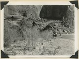 |
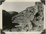
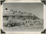
Escalante Canyon, cliff cave 3 miles above Cave Camp. Garfield County, UT, 1944 | P0013 Herbert E. Gregory Photograph Collection | P0013n12_057_2910 |
| 36 |
 |
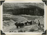
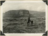
Escalante Canyon. Pueblo ruins in cliff cave. Navajo sandstone. Scale shown by horse. Garfield County, UT, 1944 | P0013 Herbert E. Gregory Photograph Collection | P0013n12_057_2911 |
| 37 |
 |
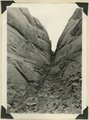
Willow Creek branch of Escalante Canyon. Entrance to 'the Narrows,' 400 feet long and 5-6 feet wide; perched log marks high water stage. Garfield County, UT, 1944 | P0013 Herbert E. Gregory Photograph Collection | P0013n12_058_2912 |
| 38 |
 |
Willow Creek branch of Escalante Canyon. In sinking its channel the creek has been guided by joints in Navajo sandstone. Garfield County, UT, 1944 | P0013 Herbert E. Gregory Photograph Collection | P0013n12_058_2913 |
| 39 |
 |
Escalante Canyon. Sheer wall of Navajo sandstone 840 feet high. Garfield County, UT, 1944 | P0013 Herbert E. Gregory Photograph Collection | P0013n12_059_2914 |
| 40 |
 |
Escalante Canyon walls of Navajo sandstone at Big Bend camp. Moonlight view. Garfield County, UT, 1944 | P0013 Herbert E. Gregory Photograph Collection | P0013n12_059_2915 |
| 41 |
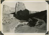 |
Escalante River at Big Bend, flowing west. After surrounding the tower of Navajo sandstone (center), the river comes within 300 feet of its east flowing section at the base of the wall (upper left). Garfield County, UT, 1944 | P0013 Herbert E. Gregory Photograph Collection | P0013n12_060_2916 |
| 42 |
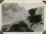 |
Escalante River at Big Bend, flowing east. At times of high water the stream flows across Kayenta formation at the meander neck (lower right). Garfield County, UT, 1944 | P0013 Herbert E. Gregory Photograph Collection | P0013n12_061_2917 |
| 43 |
 |
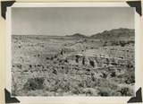
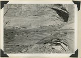
Surface of Navajo sandstone trenched by Escalante Canyon (right middle). Aquarius Plateau on skyline. Garfield County, UT, 1944 | P0013 Herbert E. Gregory Photograph Collection | P0013n12_062_2918 |
| 44 |
 |
Surface of Navajo sandstone between Escalante Canyon and Kaiparowits Plateau. Butte of Upper Jurassic rocks. Near head of Davis Creek. Garfield County, UT, 1944 | P0013 Herbert E. Gregory Photograph Collection | P0013n12_062_2919 |
| 45 |
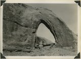 |
Gothic Arch. Width 174 feet, estimated height 190 feet. End of a buttress of Navajo sandstone resting on Kayenta. Soda Creek branch of Escalante River. Garfield County, UT, 1944 | P0013 Herbert E. Gregory Photograph Collection | P0013n12_063_2920 |
| 46 |
 |
Natural bridge of Navajo sandstone. Span 85 feet, height to girder 76 feet. Willow Creek. Garfield County, UT, 1944 | P0013 Herbert E. Gregory Photograph Collection | P0013n12_064_2921 |
| 47 |
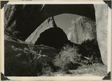 |
Natural bridge of Navajo sandstone. Span 85 feet, height to girder 76 feet. Willow Creek. Garfield County, UT, 1944 | P0013 Herbert E. Gregory Photograph Collection | P0013n12_064_2922 |
| 48 |
 |
Looking west across Panguitch. Sevier River formation (foreground), alluvium (middle distance), basalt (left center), and pyroclastic slopes leading to Little Creek Peak (background), on the east wall of Bear Valley. Garfield County, UT, 1944 | P0013 Herbert E. Gregory Photograph Collection | P0013n12_065_2923 |
| 49 |
 |
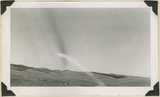
Looking northwest across Horse Lake Valley. Basalt (foreground), Pyroclastics (background). Garfield County, UT, 1944 | P0013 Herbert E. Gregory Photograph Collection | P0013n12_066_2924 |
| 50 |
 |
Treeless slope developed on pyroclastic and igneous rocks typical of areas west of Panguitch Creek. Garfield County, UT, 1944 | P0013 Herbert E. Gregory Photograph Collection | P0013n12_066_2925 |