|
|
Title | Date | Type | Setname |
| 176 |
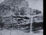 |
"Waterfall behind corral" | 1910; 1911; 1912; 1913; 1914; 1915; 1916; 1917; 1918; 1919; 1920; 1921; 1922; 1923; 1924; 1925; 1926; 1927; 1928; 1929; 1930; 1931; 1932; 1933; 1934; 1935; 1936; 1937; 1938; 1939; 1940; 1941; 1942; 1943; 1944; 1945; 1946; 1947; 1948; 1949; 1950; 1951; 195 | | uum_map_rr |
| 177 |
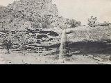 |
"Waterfall behind corral." Florence Creek (Cradle M) ranch | 1910; 1911; 1912; 1913; 1914; 1915; 1916; 1917; 1918; 1919; 1920; 1921; 1922; 1923; 1924; 1925; 1926; 1927; 1928; 1929; 1930; 1931; 1932; 1933; 1934; 1935; 1936; 1937; 1938; 1939; 1940; 1941; 1942; 1943; 1944; 1945; 1946; 1947; 1948; 1949; 1950; 1951; 195 | | uum_map_rr |
| 178 |
 |
"White face cows at the ranch." Near 2nd McPherson Cabin (now known as Himonas Cabin) on West Tavaputs Plateau at head of right fork of Three Canyon. Known locally as "The Hole" | 1910; 1911; 1912; 1913; 1914; 1915; 1916; 1917; 1918; 1919; 1920; 1921; 1922; 1923; 1924; 1925; 1926; 1927; 1928; 1929; 1930; 1931; 1932; 1933; 1934; 1935; 1936; 1937; 1938; 1939; 1940; 1941; 1942; 1943; 1944; 1945; 1946; 1947; 1948; 1949; 1950; 1951; 195 | | uum_map_rr |
| 179 |
 |
"Willard and his adopted brother Robert." | 1930; 1931; 1932; 1933; 1934; 1935; 1936; 1937; 1938; 1939; 1940; 1941; 1942; 1943; 1944; 1945; 1946; 1947; 1948; 1949; 1950 | Image | uum_map_usa |
| 180 |
 |
"Willard and Robert growing up." | 1930; 1931; 1932; 1933; 1934; 1935; 1936; 1937; 1938; 1939; 1940; 1941; 1942; 1943; 1944; 1945; 1946; 1947; 1948; 1949; 1950 | Image | uum_map_usa |
| 181 |
 |
"Willard and Stayner were on missions at the same time. Willard head of Scottish and Stayner head of British missions." | 1910; 1911; 1912; 1913; 1914; 1915; 1916; 1917; 1918; 1919; 1920; 1921; 1922; 1923; 1924; 1925; 1926; 1927; 1928; 1929; 1930; 1931; 1932; 1933; 1934; 1935; 1936; 1937; 1938; 1939; 1940 | Image | uum_map_usa |
| 182 |
 |
"Willard at the end of his mission." | 1910; 1911; 1912; 1913; 1914; 1915; 1916; 1917; 1918; 1919; 1920; 1921; 1922; 1923; 1924; 1925; 1926; 1927; 1928; 1929; 1930; 1931; 1932; 1933; 1934; 1935; 1936; 1937; 1938; 1939; 1940 | Image | uum_map_usa |
| 183 |
 |
"Willard in his Scottish kilts while on his mission." | 1910; 1911; 1912; 1913; 1914; 1915; 1916; 1917; 1918; 1919; 1920; 1921; 1922; 1923; 1924; 1925; 1926; 1927; 1928; 1929; 1930; 1931; 1932; 1933; 1934; 1935; 1936; 1937; 1938; 1939; 1940 | Image | uum_map_usa |
| 184 |
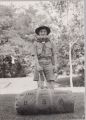 |
"Willard Jr., Boy Scout on his way to the Scout Jamboree in Washington D.C." | 1930; 1931; 1932; 1933; 1934; 1935; 1936; 1937; 1938; 1939; 1940; 1941; 1942; 1943; 1944; 1945; 1946; 1947; 1948; 1949; 1950 | Image | uum_map_usa |
| 185 |
 |
"Willard starting his mission." | 1910; 1911; 1912; 1913; 1914; 1915; 1916; 1917; 1918; 1919; 1920; 1921; 1922; 1923; 1924; 1925; 1926; 1927; 1928; 1929; 1930; 1931; 1932; 1933; 1934; 1935; 1936; 1937; 1938; 1939; 1940 | Image | uum_map_usa |
| 186 |
 |
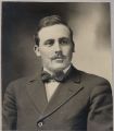
"William Richards leaving for mission." | 1940; 1941; 1942; 1943; 1944; 1945; 1946; 1947; 1948; 1949; 1950; 1951; 1952; 1953; 1954; 1955; 1956; 1957; 1958; 1959; 1960 | Image | uum_map_usa |
| 187 |
 |
"Willow Springs." McPherson family on horses gathered in front of an old log cabin at Willow Springs | 1910; 1911; 1912; 1913; 1914; 1915; 1916; 1917; 1918; 1919; 1920; 1921; 1922; 1923; 1924; 1925; 1926; 1927; 1928; 1929; 1930; 1931; 1932; 1933; 1934; 1935; 1936; 1937; 1938; 1939; 1940; 1941; 1942; 1943; 1944; 1945; 1946; 1947; 1948; 1949; 1950; 1951; 195 | | uum_map_rr |
| 188 |
 |
"Zelpha and Jerry." Zelpha McPherson and horse | 1910; 1911; 1912; 1913; 1914; 1915; 1916; 1917; 1918; 1919; 1920; 1921; 1922; 1923; 1924; 1925; 1926; 1927; 1928; 1929; 1930; 1931; 1932; 1933; 1934; 1935; 1936; 1937; 1938; 1939; 1940; 1941; 1942; 1943; 1944; 1945; 1946; 1947; 1948; 1949; 1950; 1951; 195 | | uum_map_rr |
| 189 |
 |
"Zelpha and Jerry." Zelpha McPherson and horse | 1910; 1911; 1912; 1913; 1914; 1915; 1916; 1917; 1918; 1919; 1920; 1921; 1922; 1923; 1924; 1925; 1926; 1927; 1928; 1929; 1930; 1931; 1932; 1933; 1934; 1935; 1936; 1937; 1938; 1939; 1940; 1941; 1942; 1943; 1944; 1945; 1946; 1947; 1948; 1949; 1950; 1951; 1952 | | uum_map_rr |
| 190 |
 |
'White Throne' remnant of Navajo sandstone in branch of Paria River. Kane County, UT, 1940 | 1940 | Image | uum_map |
| 191 |
 |
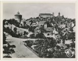
(C) Castle Yard, Nuremberg, Germany (before Allied bombings of 1944-1945) | 1935; 1936; 1937; 1938; 1939; 1940; 1941; 1942; 1943; 1944 | Image | uum_map |
| 192 |
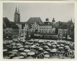 |
(D) Market Place "Old City", Nuremberg, Germany (before Allied bombings of 1944-1945) | 1935; 1936; 1937; 1938; 1939; 1940; 1941; 1942; 1943; 1944 | Image | uum_map |
| 193 |
 |
(E) View from Haller Gate, Nuremberg, Germany (before Allied bombings of 1944-1945) | 1935; 1936; 1937; 1938; 1939; 1940; 1941; 1942; 1943; 1944 | Image | uum_map |
| 194 |
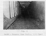 |
(Fig. 11) "Drift-Bonanza Mine (Before 1945 fire)." | 1940; 1941; 1942; 1943; 1944; 1945 | | uum_map |
| 195 |
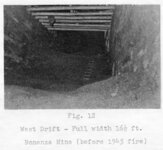 |
(Fig. 12) "West drift - Full width 16½ ft. [at] Bonanza Mine (before 1945 fire)." | 1940; 1941; 1942; 1943; 1944; 1945 | | uum_map |
| 196 |
 |
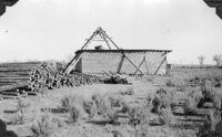
(Fig. 24b) "Wayne Thomas, mining engineer in charge, and a party of visitors inspecting preparations for pouring the concrete for the retaining wall to hold out surface water and sand until a reinforced [sic] concrete collar could be constructed on the bed-rock [sic] about 15 feet below the surface. Note several sacks of gilsonite salvaged from the vein in order to make room for the shaft collar." | 1940 | | uum_map |
| 197 |
 |
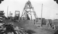
(Fig. 25a) "West view of Arrowchis Shaft showing head frame, loading platform (walled in on windward sides), simple built-in screening plant a rack of sacked gilsonite, and two stockholders, R. L. Hedrick (left), and Harry Pearson. The upper deck served as a protective shed for the loading platform and as a floor to hold each digger's sacks, as they were hoisted from the stopes, until they were sorted, graded, and screened, after which they were racked on the loading platform below for shipment." | 1940 | | uum_map |
| 198 |
 |
(Fig. 25b) "North view of Arrowchis Shaft of the Western Gilsonite and Elaterite Company, showing four-pole construction of simple head frame. Note mine timber and bath-house (to left and beyond shed). Clothes-line and small building to right of shed are just west of Superintendent's house hidden by the head frame and loading shed." | 1940 | | uum_map |
| 199 |
 |
(Fig. 26a) "View from edge of River Terrace looking southeast along the strike fo the Fort Duchesne Vein toward the Arrowchis Lease from near the point of original discovery of this vein, just northwest of the commercial portion of the vein. Over the top of the house in the center can be seen the dim outline of a string of headframes (including those in "B" below) over the closely-spaced shafts of the Raven Mining Company." | 1940 | | uum_map |
| 200 |
 |
(Fig. 26b) "Headframes over tow chief shafts on the Raven Mining Company's portion of the Fort Duchesne vein. These shafts were deepened and somewhat modernized to service the lower levels. The shafts between, and on either side were then abandoned. Note hand screening equipment, power line, and slabs for lagging the ming." | 1940 | | uum_map |