Home
Browse
Ask Us
Chat
Harmful Language Statement
Log in
Photo Archives
Advanced Search
About
Over 70,000 photos covering a variety of topics from Marriott Library Special Collections
Year
1845
1846
1847
1848
1849
1850
1851
1852
1853
1854
1855
1856
1857
1858
1859
1860
1861
1862
1863
1864
1865
1866
1867
1868
1869
1870
1871
1872
1873
1874
1875
1876
1877
1878
1879
1880
1881
1882
1883
1884
1885
1886
1887
1888
1889
1890
1891
1892
1893
1894
1895
1896
1897
1898
1899
1900
1901
1902
1903
1904
1905
1906
1907
1908
1909
1910
1911
1912
1913
1914
1915
1916
1917
1918
1919
1920
1921
1922
1923
1924
1925
1926
1927
1928
1929
1930
1931
1932
1933
1934
1935
1936
1937
1938
1939
1940
1941
1942
1943
1944
1945
1946
1947
1948
1949
1950
1951
1952
1953
1954
1955
1956
1957
1958
1959
1960
1961
1962
1963
1964
1965
1966
1967
1968
1969
1970
1971
1972
1973
1974
1975
1976
1977
1978
1979
1980
1981
1982
1983
1984
1985
1986
1987
1988
1989
1990
1991
1992
1993
1994
1995
1996
1997
1998
1999
2000
TO
1845
1846
1847
1848
1849
1850
1851
1852
1853
1854
1855
1856
1857
1858
1859
1860
1861
1862
1863
1864
1865
1866
1867
1868
1869
1870
1871
1872
1873
1874
1875
1876
1877
1878
1879
1880
1881
1882
1883
1884
1885
1886
1887
1888
1889
1890
1891
1892
1893
1894
1895
1896
1897
1898
1899
1900
1901
1902
1903
1904
1905
1906
1907
1908
1909
1910
1911
1912
1913
1914
1915
1916
1917
1918
1919
1920
1921
1922
1923
1924
1925
1926
1927
1928
1929
1930
1931
1932
1933
1934
1935
1936
1937
1938
1939
1940
1941
1942
1943
1944
1945
1946
1947
1948
1949
1950
1951
1952
1953
1954
1955
1956
1957
1958
1959
1960
1961
1962
1963
1964
1965
1966
1967
1968
1969
1970
1971
1972
1973
1974
1975
1976
1977
1978
1979
1980
1981
1982
1983
1984
1985
1986
1987
1988
1989
1990
1991
1992
1993
1994
1995
1996
1997
1998
1999
2000
Type
Image
2,638
Image/StillImage
1,494
Format
image/jpeg
4,536
application/pdf
613
Collection Name
Shipler Studio
857
Everett Ruess Family
598
Emigration Canyon History
275
Ruth Harwood
223
The Institute of the American West photograph collection, 1886-1985
221
Olive Woolley Burt
166
Maud May Babcock
154
Deseret Livestock Company
147
Charles Neal
118
Herbert E. Gregory
114
Vern Adix
101
Kennecott Copper Corporation
95
Ray Yourdon
94
G. Ernst Untermann
90
George D. Pyper
85
Mining Photograph Collection
83
William Manning Green
80
Albion W. and Agnes Sharp Caine
72
Reo Robbins
59
Sumi Niiya Takemoto
58
J. Willard and Alice Sheets Marriott
54
A. J. Peters
51
G. Bennet Larson
51
Ivy Baker Priest
51
Leo Leonard
49
Carl Weeks Photograph Collection
46
Philo T. Farnsworth
46
Greek Archives
45
C. Lowell Lees
40
Wallace Stegner
39
Omer Call Stewart photograph collection
38
Alta Club
33
Wasatch Mountain Club
33
Charles Kelly
32
Sigmund and Emma Helwing
31
Fort Douglas
30
Joe Hill Conference
29
Topaz, Utah and Hispanics in Utah films, 1940-1990
28
American Red Cross
25
Hole-in-the-Rock
25
Gosiute Indians
24
Utah Railroads
24
E. A. Taylor
23
Utah's Silver Queen: Susanna Egera Bransford Emery Holmes Delitch Engalitcheff photograph collection
23
Bingham Canyon
20
Rocky Mountain Power Company
18
Waldo Wilcox
18
Clifford Percy Evans
16
JoAnne C. Swindle photograph collection
16
Francis Armstrong
15
Marriner S. Eccles
15
Melba Goff Matthews
14
Charles N. Strevell
13
Combined Metals Reduction Company
13
Croydon Utah/Devil's Slide Cement Plant
13
Elsie Ross Whittaker
13
Geraldine Palmer Jones
13
Julia Farnsworth Lund Wassmer
13
Wallace and Mary Doi
12
George Snell
11
Henry Y. Kasai
9
Jean Westwood
9
John A. Peperakis
9
Portrait photograph collection
9
Utah Humanities Research Foundation
9
Utah Schools photograph collection
9
Vyrie Gray
9
Salt Lake Oratorio Society photograph collection
8
Utah Postcard
8
Reva Beck Bosone
7
Seamount Family
7
Sylvia Eugene Nilsen
7
Uheiji Charles Akita
7
Alberta Henry
6
B. Floyd Farr
6
Earl Wells
6
Garfield, Utah
6
Hope A. Hilton
6
Mark A. Pendleton
6
McLean Watters
6
Preston Nutter Corporation
6
Ralph Chamberlin
6
Vontella Hess Bucholz Kimball
6
Clarice Short photograph collection
5
Edna Clark Ericksen
5
Ivor Sharp
5
Joseph E. Johnson
5
Millard F. Malin Photographs
5
Provo, Utah
5
Wanda Clayton Thomas
5
History of Bingham Canyon
4
Jack Paige
4
Japanese Church of Christ
4
Mack Smith Kesler
4
Rose Thomas Graham
4
Alfred Jones
3
Darrell J. Greenwell
3
David Oman McKay
3
Faith Terasawa
3
Francis Urry
3
Helen Bowring Ure photograph collection
3
Jack Warren Keuffel photograph collection, 1946-1974
3
Japanese American Citizens League Japanese in Utah Exhibit
3
John Hamilton Morgan
3
Joseph Peck
3
Joy and Lee She Ju digital photograph collection
3
Kathy Nielson
3
LaVar Webb
3
LeRoy Robertson photograph collection, 1945-1960
3
Louis E. Viko
3
Mary Jane Mount Tanner
3
Park City, Utah
3
Sunstone Foundation photograph collection
3
William Caine Patrick
3
William P. Nisbet photograph collection
3
Alice Lovina Manning Photographs
2
Alvin G. and Lena M. Pack
2
Arch Leonard Madsen
2
Asael Carlyle
2
Benjamin M. Roe
2
Bingham Stage Lines
2
Burton W. Musser photograph collection, 1900-1966
2
Byron A. Hunter photograph collection
2
Daniel Hadlond Thomas
2
David Breck Morris
2
Dinwoodey Furniture Company
2
E. Jay Bell
2
Edna Peterson Price
2
Esther Landa photograph collection
2
Harry L. A. Culmer photograph collection
2
Hiram B. Clawson
2
Janet Pender Healy
2
Yosaburo Takehara digital photograph collection
2
Agnes Just Reid
1
Allen Publishing Company
1
Barbara J. Hamblin
1
Blanche Kendall McKey
1
Charles H. Monson photograph collection
1
Cheves Walling
1
Colorado
1
Dawn Aoki photograph collection
1
Edith LeRoy Richardson
1
Elmore LeRoy photograph collection
1
Ephraim Edward Ericksen
1
Frederick J. Pack
1
George A. Smith
1
George Reynolds
1
Hispanic
1
Howard D. Johnson
1
James Edward Talmage
1
John W. Summerhays
1
John and Elva Murdock
1
Joseph Kingsbury
1
Knight Belnap Kerr photograph collection, 1935-1942
1
Kunio Yamada digital photograph collection
1
Lowry Nelson
1
Lyman P. Hunter
1
Marvin H. Strong photograph collection
1
Maurice Abravanel
1
Mike M. Masaoka
1
Miles Pratt Romney
1
Philip T. Blair
1
Sunnyside, Utah
1
U of U Presidents
1
Vernal, Utah
1
Virginia Nester photograph collection
1
Works Progress Administration
1
More
Filters:
Date:
"1939"
Collection:
"uum_map"
251
-
275
of
5,149
<
6
7
8
9
10
11
12
13
14
15
>
Gallery view
Number of results to display per page
10
25
50
100
200
Sort by Relevance
Sort by Title A-Z
Sort by Title Z-A
Sort by Date Ascending
Sort by Date Descending
Sort by Last Modified Ascending
Sort by Last Modified Descending
Sort by Photo Number
Title
Collection Number And Name
Photo Number
251
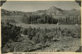
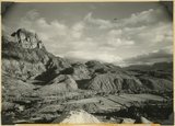
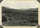
Kaibab Indian School looking north. Alluvial flats at head of Two Mile Wash. Branch of Sevier fault passes between Navajo (left distance) and Chinle-Navajo (middle distance), Mohave County, AZ. 1939
P0013 Herbert E. Gregory Photograph Collection
P0013n11_089_2671
252
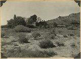
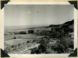
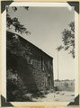
'Winsor Castle,' old stone fort at Pipe Springs, Mohave County, AZ. Sevier fault passes between Navajo sandstone." (upper right) and lower Moenkopi (foreground). 1939
P0013 Herbert E. Gregory Photograph Collection
P0013n11_090_2672
253
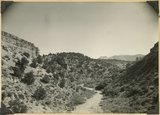
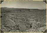
Alluvial terraces on Kanab Creek near mouth of Tiny Canyon, Kane County, UT. 1939. Excavated since 1882
P0013 Herbert E. Gregory Photograph Collection
P0013n11_090_2673
254
Fault in Jurassic formations 3 miles south of Mt. Carmel. Carmel limestone (left). Entrada and Carmel (right). Elkheart Cliffs (Navajo) (upper right). Kane County, UT, 1939
P0013 Herbert E. Gregory Photograph Collection
P0013n11_091_2674
255
General view of tilted Jurassic and Cretaceous beds looking northwest across Parunuweap Valley from base of Elkheart Cliffs southwest of Mt. Carmel; Valley of Muddy Brook (center) is at the contact of Winsor and Dakota formations (left) and Tropic shale (right), Kane County, UT, 1939
P0013 Herbert E. Gregory Photograph Collection
P0013n11_091_2675
256
View looking south down Meadow Brook across Parunuweap Canyon to Block Mesas on Moccasin Terrace. Canyon cut in San Rafael strata. Pinions or Juniper. Kane County, UT. 1939
P0013 Herbert E. Gregory Photograph Collection
P0013n11_092_2676
257
Landslide (all the material in view) near mouth of Birch Creek, Zion Canyon. Covers upper part of and Springdale member (lower left) of the Chinle. Still active: Virgin river flows in groove at left of road, Washington County, UT, 1939
P0013 Herbert E. Gregory Photograph Collection
P0013n11_092_2677
258
Landslide, 1 mile south of Springdale, covers strata from base of Navajo (top left) to Shinarump. Springdale member of Chinle (left middle). Washington County, UT. 1939
P0013 Herbert E. Gregory Photograph Collection
P0013n11_093_2678
259
Landslide at mouth of Parunuweap (right center) extends from south of Springdale (foreground) across Parunuweap to base of Eagle Crags (top center). Involves entire Chinle formation. Washington County, UT. 1939
P0013 Herbert E. Gregory Photograph Collection
P0013n11_093_2679
260
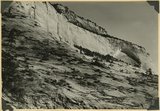
Navajo sandstone including Temple cap member (top). Shows typical recessed arch. Near east entrance, Zion Park, Kane County, UT. 1939
P0013 Herbert E. Gregory Photograph Collection
P0013n11_094_2680
261
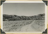
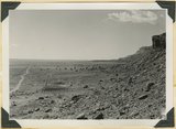
View looking south-southwest across Timpoweap Canyon (center) to crest of Hurricane Cliffs (skyline). Floor chiefly the surface of east dipping beds of Timpoweap member of the Moenkopi. Lava capped mesas of upper Moenkopi (left distance). West of Virgin City. Washington County, UT. 1939
P0013 Herbert E. Gregory Photograph Collection
P0013n11_094_2681
262
View looking up Virgin River from a point 2 miles west of Virgin City, valley floor lower Moenkopi. Virgin member caps mesa(front ). Shinarump the terraces upstream. Navajo sandstone of South Mountain (right). Kinesawa Mountain (left) on skyline, Washington County, UT. 1939
P0013 Herbert E. Gregory Photograph Collection
P0013n11_095_2682
263
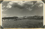
Hurricane Cliffs at Anderson Ranch. Kaibab and lower Moenkopi. Basalt (middle and upper right). Washington County, UT. 1939
P0013 Herbert E. Gregory Photograph Collection
P0013n11_095_2683
264
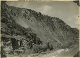
Wasatch formation near mouth of Red Canyon. Gray conglomerate unconformable over massive pink limestone. Above it friable limestone, volcanic ash and basalt, Garfield County, UT. 1939
P0013 Herbert E. Gregory Photograph Collection
P0013n11_097_2684
265
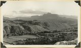
Sunset Cliffs as viewed east of Hatch. Sevier fault follows base of cliffs that include Cretaceous and Wasatch Pink Cliffs on skyline. Garfield County, UT, 1939
P0013 Herbert E. Gregory Photograph Collection
P0013n11_098_2685
266
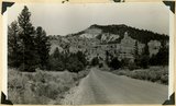
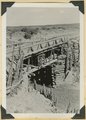
Bridge built by C.C.C. across recently eroded wash, near Pipe Springs. Mohave County, AZ. 1939
P0013 Herbert E. Gregory Photograph Collection
P0013n11_098_2686
267
Cedar Ridge. Cap of Shinarump conglomerate and upper Moenkopi extending south from Vermillion Cliffs onto Uinkaret Plateau west of Pipe Wash, Mohave County, AZ. 1939
P0013 Herbert E. Gregory Photograph Collection
P0013n11_099_2687
268
Settlement of Moccasin Springs looking eastward toward Kaibab Indian School. Kaibab Plateau on skyline. Mohave County, AZ. 1939
P0013 Herbert E. Gregory Photograph Collection
P0013n11_099_2688
269
View northward over Moccasin Springs along Sevier fault. Navajo (left) and Chinle (right), on skyline. 1939. Deep alluvium trenched by stream from springs (foreground)
P0013 Herbert E. Gregory Photograph Collection
P0013n11_100_2689
270
Gypsum in Curtis formation near Highway 89 crossing of Muddy Brook, Kane County, UT. 1939
P0013 Herbert E. Gregory Photograph Collection
P0013n11_100_2690
271
'Winsor Castle', old fort at Pipe Springs, looking south over Unikaret Plateau, Kanab Canyon upper right
P0013 Herbert E. Gregory Photograph Collection
P0013n11_101_2690
272
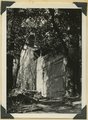
Door of "Winsor Castle," Pipe Springs, Mohave County, Ariz. 1939
P0013 Herbert E. Gregory Photograph Collection
P0013n11_101_2691
273
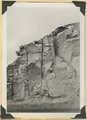
Walls of "Winsor Castle," headquarters for Pipe Springs National Monument. Modern doors and windows replace "rifle grooves," Mohave Co., Ariz. 1939
P0013 Herbert E. Gregory Photograph Collection
P0013n11_102_2692
274
Erosion surface at edge of Vermillion Cliffs west of Pipe Springs, Mohave County, AZ. Streams cross Sevier fault from downthrow to upthrow side. 1939
P0013 Herbert E. Gregory Photograph Collection
P0013n11_102_2693
275
Cowboy Butte 2 miles north of Fredonia. Moenkopi (Shnabkaib member at base) and Shinarump, Coconino County, AZ. 1939
P0013 Herbert E. Gregory Photograph Collection
P0013n11_103_2694
251
-
275
of
5,149
<
6
7
8
9
10
11
12
13
14
15
>