Home
Browse
Ask Us
Chat
Harmful Language Statement
Log in
Photo Archives
Advanced Search
About
Over 90,000 photos covering a variety of topics from Marriott Library Special Collections.
Year
1900
1901
1902
1903
1904
1905
1906
1907
1908
1909
1910
1911
1912
1913
1914
1915
1916
1917
1918
1919
1920
1921
1922
1923
1924
1925
1926
1927
1928
1929
1930
1931
1932
1933
1934
1935
1936
1937
1938
1939
1940
1941
1942
1943
1944
1945
1946
1947
1948
1949
1950
1951
1952
1953
1954
1955
1956
1957
1958
1959
1960
1961
1962
1963
1964
1965
1966
1967
1968
1969
TO
1900
1901
1902
1903
1904
1905
1906
1907
1908
1909
1910
1911
1912
1913
1914
1915
1916
1917
1918
1919
1920
1921
1922
1923
1924
1925
1926
1927
1928
1929
1930
1931
1932
1933
1934
1935
1936
1937
1938
1939
1940
1941
1942
1943
1944
1945
1946
1947
1948
1949
1950
1951
1952
1953
1954
1955
1956
1957
1958
1959
1960
1961
1962
1963
1964
1965
1966
1967
1968
1969
Type
Image
57
Image/StillImage
9
Format
image/jpeg
35
application/pdf
31
Collection Name
Herbert E. Gregory
25
Olive Woolley Burt
16
Everett Ruess Family
15
Carl Weeks
7
Ray Yourdon
1
Salt Lake Oratorio Society
1
Wallace Stegner
1
More
Filters:
Date:
"1939"
Collection:
"uum_map"
Spatial Coverage:
"Arizona"
1
-
25
of
66
<
1
2
3
>
Gallery view
Number of results to display per page
10
25
50
100
200
Sort by Relevance
Sort by Title A-Z
Sort by Title Z-A
Sort by Date Ascending
Sort by Date Descending
Sort by Last Modified Ascending
Sort by Last Modified Descending
Sort by Photo Number
Title
Collection Number And Name
Photo Number
1
Herbert E. Gregory Book 11: Colorado Plateau, 1938-1942
P0013 Herbert E. Gregory Photograph Collection
P0013n11
2
The Steamboat. Shnabkaib (bottom) and upper red level of Moenkopi capped in part by Shinarump 2 miles west of Fredonia, Coconino County, AZ. 1939
P0013 Herbert E. Gregory Photograph Collection
P0013n11_061_2628
3
The Steamboat. Shnabkaib (bottom) and upper red level of Moenkopi capped in part by Shinarump 2 miles west of Fredonia, Coconino County, AZ. 1939
P0013 Herbert E. Gregory Photograph Collection
P0013n11_062_2629
4
Northern edge Kanab Plateau. Village of Fredonia on surface eroded from lower Moenkopi beds and crossed by Kanab Creek. Buttes of Moenkopi capped by Shinarump (right), Coconino County, August, 1939
P0013 Herbert E. Gregory Photograph Collection
P0013n11_067_2637
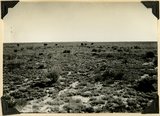
5
Surface of Uinkaret Plateau southwest of Cane Beds, Mohave County, AZ, Aug. 2, 1939
P0013 Herbert E. Gregory Photograph Collection
P0013n11_067_2638
6
Shinarump and Moenkopi beds disturbed by a local fault 3 miles north of Fredonia, Coconino County, AZ. 1939
P0013 Herbert E. Gregory Photograph Collection
P0013n11_069_2641
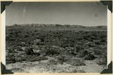
7
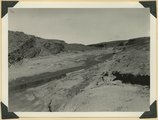
Erosion surface produced by bevelling Chinle strata at the base of Vermillion Cliffs south of Cane Beds, Mohave County, AZ, 1939
P0013 Herbert E. Gregory Photograph Collection
P0013n11_073_2648
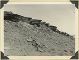
8
Moenkopi showing typical erosion of its shaly sandstones on Hurricane-Antelope Springs Road, Mohave County, AZ. 1939
P0013 Herbert E. Gregory Photograph Collection
P0013n11_074_2649
9
Fault in lower Moenkopi shaly sandstone head of Rock Canyon (of Short Creek), Mohave County, AZ, 1939
P0013 Herbert E. Gregory Photograph Collection
P0013n11_075_2651
10
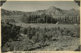
Folds in Moenkopi strata, Short Creek east of Rock Canyon, Mohave County, AZ, 1939
P0013 Herbert E. Gregory Photograph Collection
P0013n11_075_2652
11
South wall of Rock Canyon. Kaibab (on valley floor and up to first ledge), conglomerate, Moenkopi (upper part of slope and the cliffs), Mohave County, AZ, 1939
P0013 Herbert E. Gregory Photograph Collection
P0013n11_076_2653
12
Short Creek near the exit from its canyon, in Vermillion Cliffs. Alluvial terraces and broad channel made during past 50 years, Mohave County, AZ, 1939
P0013 Herbert E. Gregory Photograph Collection
P0013n11_076_2654
13
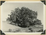
Cottonwood trees buried by sand dunes; trunks reexposed by recent excavations of alluvial valley fill, Short Creek, Mohave County, AZ, 1939
P0013 Herbert E. Gregory Photograph Collection
P0013n11_077_2655
14
Kaibab Indian School near Moccasin looking northeast toward head of Two Mile Wash. Deep alluvial fill. Moenkopi capped by Shinarump (upper right), Chinle and Glen Canyon beds cliffs at upper left and middle distance (Lambs Point). Branch of Sevier fault crosses divide between Two Mile Wash and Sand Creek at base of Indian Point (left middle), Mohave County, AZ. 1939
P0013 Herbert E. Gregory Photograph Collection
P0013n11_089_2670
15
Kaibab Indian School looking north. Alluvial flats at head of Two Mile Wash. Branch of Sevier fault passes between Navajo (left distance) and Chinle-Navajo (middle distance), Mohave County, AZ. 1939
P0013 Herbert E. Gregory Photograph Collection
P0013n11_089_2671
16
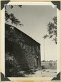
'Winsor Castle,' old stone fort at Pipe Springs, Mohave County, AZ. Sevier fault passes between Navajo sandstone." (upper right) and lower Moenkopi (foreground). 1939
P0013 Herbert E. Gregory Photograph Collection
P0013n11_090_2672
17
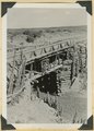
Bridge built by C.C.C. across recently eroded wash, near Pipe Springs. Mohave County, AZ. 1939
P0013 Herbert E. Gregory Photograph Collection
P0013n11_098_2686
18
Cedar Ridge. Cap of Shinarump conglomerate and upper Moenkopi extending south from Vermillion Cliffs onto Uinkaret Plateau west of Pipe Wash, Mohave County, AZ. 1939
P0013 Herbert E. Gregory Photograph Collection
P0013n11_099_2687
19
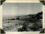
Settlement of Moccasin Springs looking eastward toward Kaibab Indian School. Kaibab Plateau on skyline. Mohave County, AZ. 1939
P0013 Herbert E. Gregory Photograph Collection
P0013n11_099_2688
20
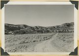
View northward over Moccasin Springs along Sevier fault. Navajo (left) and Chinle (right), on skyline. 1939. Deep alluvium trenched by stream from springs (foreground)
P0013 Herbert E. Gregory Photograph Collection
P0013n11_100_2689
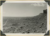
21
'Winsor Castle', old fort at Pipe Springs, looking south over Unikaret Plateau, Kanab Canyon upper right
P0013 Herbert E. Gregory Photograph Collection
P0013n11_101_2690
22
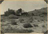
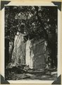
Door of "Winsor Castle," Pipe Springs, Mohave County, Ariz. 1939
P0013 Herbert E. Gregory Photograph Collection
P0013n11_101_2691
23
Walls of "Winsor Castle," headquarters for Pipe Springs National Monument. Modern doors and windows replace "rifle grooves," Mohave Co., Ariz. 1939
P0013 Herbert E. Gregory Photograph Collection
P0013n11_102_2692
24
Erosion surface at edge of Vermillion Cliffs west of Pipe Springs, Mohave County, AZ. Streams cross Sevier fault from downthrow to upthrow side. 1939
P0013 Herbert E. Gregory Photograph Collection
P0013n11_102_2693
25
Cowboy Butte 2 miles north of Fredonia. Moenkopi (Shnabkaib member at base) and Shinarump, Coconino County, AZ. 1939
P0013 Herbert E. Gregory Photograph Collection
P0013n11_103_2694
1
-
25
of
66
<
1
2
3
>