|
|
Title | Collection Number And Name | Photo Number |
| 151 |
 |
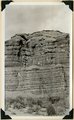
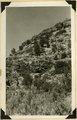
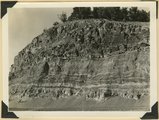
Massive sandstone of Wahweap (?) formation, Tenney Canyon, Kane County, Utah, 1938. | P0013 Herbert E. Gregory Photograph Collection | P0013n10_236_2506 |
| 152 |
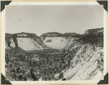
 |
Same as 1165 [White bed in Kaiparowits formation (bed 38 of measured section), Tenny Canyon, Kane County, UT 1938] | P0013 Herbert E. Gregory Photograph Collection | P0013n11_001_2527 |
| 153 |
 |
Same as 1167 [Moenkopi formation 2± miles west of Paria on old Kanab Trail. Kane County, UT, 1938] | P0013 Herbert E. Gregory Photograph Collection | P0013n11_001_2528 |
| 154 |
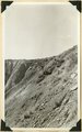 |
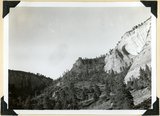
Fault. Wasatch Tertiary on left (west); Cretaceous on right; head of Paria Canyon. Garfield County, UT, 1938 | P0013 Herbert E. Gregory Photograph Collection | P0013n11_002_2529 |
| 155 |
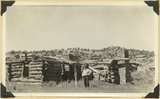 |
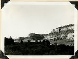
Headquarters of old Kitchen Ranch, Kitchen Canyon. Kane County, UT, 1938. Bronson Stringham standing | P0013 Herbert E. Gregory Photograph Collection | P0013n11_003_2530 |
| 156 |
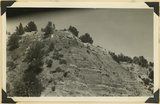 |
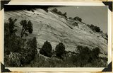
Entrada sandstone overlain by the heavy gypsum bed of the Curtis formation. Carmel limestone at left brought to level of Entrada by a fault, on Highway 15 near junction with Highway 89. Kane County, UT, 1938 | P0013 Herbert E. Gregory Photograph Collection | P0013n11_003_2531 |
| 157 |
 |
Temple Cap member of the Navajo formation overlain by Carmel limestone, head of Parunuweap Canyon. Kane County, UT, 1938 | P0013 Herbert E. Gregory Photograph Collection | P0013n11_004_2532 |
| 158 |
 |
Temple Cap member of the Navajo formation near east entrance to Zion National Park, Kane County, UT, 1938 | P0013 Herbert E. Gregory Photograph Collection | P0013n11_004_2533 |
| 159 |
 |
East Temple. Buttress forms wall of Pine Creek; Navajo sandstone; top, Temple cap member. Zion National Park, 1938 | P0013 Herbert E. Gregory Photograph Collection | P0013n11_005_2534 |
| 160 |
 |
Bridge Mountain. Navajo sandstone; view south base of East Temple across Pine Creek; Tunnel Road lower right. Zion National Park, 1938 | P0013 Herbert E. Gregory Photograph Collection | P0013n11_005_2535 |
| 161 |
 |
Part of Chinle formation above Springdale member; sandstone, shales and lime conglomerates. Pine Valley. Zion National Park, 1938 | P0013 Herbert E. Gregory Photograph Collection | P0013n11_006_2536 |
| 162 |
 |
Site of Springdale, Virgin River Valley, below mouth of Zion Canyon. At left, the Watchman. Navajo sandstone, underlaid by Chinle: middle cliff is Springdale member. Washington County, UT | P0013 Herbert E. Gregory Photograph Collection | P0013n11_007_2538 |
| 163 |
 |
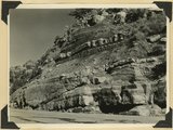
Contact Carmel limestone (top) and Navajo (bottom), between them calcareous and argillaceous shales. Kane County, UT | P0013 Herbert E. Gregory Photograph Collection | P0013n11_008_2539 |
| 164 |
 |
Lava flow over Navajo sandstone, near Pine Springs, Kolob Terrace. Washington County, UT | P0013 Herbert E. Gregory Photograph Collection | P0013n11_009_2540 |
| 165 |
 |
Wingate, Kayenta, and Navajo. Kanab Canyon 2+ miles above junction of Three Lakes. Kane County, UT | P0013 Herbert E. Gregory Photograph Collection | P0013n11_009_2541 |
| 166 |
 |
East wall Meadow Brook Canyon, near highway crossing. Carmel limestone (bottom), Entrada, Curtis, Winsor, Dakota (black band, upper left), base of Tropic shales. Kane County, UT | P0013 Herbert E. Gregory Photograph Collection | P0013n11_010_2542 |
| 167 |
 |
Navajo sandstone, above it (offset) Temple Cap member projected by Carmel limestone. View from base of East Temple. Washington County, UT | P0013 Herbert E. Gregory Photograph Collection | P0013n11_011_2543 |
| 168 |
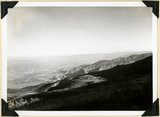 |
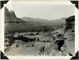
Near west edge of Kolob Terrace, looking northeast across mouth of Coal Creek; tilted rocks at Hurricane fault (middle); Cedar City, lower left. Iron County, UT | P0013 Herbert E. Gregory Photograph Collection | P0013n11_011_2544 |
| 169 |
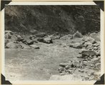 |
Virgin River in Zion National Park: rising flood from shower on Kolob Terrace | P0013 Herbert E. Gregory Photograph Collection | P0013n11_012_2545 |
| 170 |
 |
Virgin River in Zion National Park: rising flood from shower on Kolob Terrace | P0013 Herbert E. Gregory Photograph Collection | P0013n11_013_2546 |
| 171 |
 |
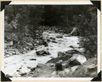
Virgin River in Zion National Park: flood stage | P0013 Herbert E. Gregory Photograph Collection | P0013n11_013_2547 |
| 172 |
 |
Virgin River in Zion National Park: flood stage | P0013 Herbert E. Gregory Photograph Collection | P0013n11_014_2548 |
| 173 |
 |
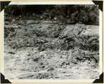
Virgin River in Zion National Park: erosion of land slide at flood stage | P0013 Herbert E. Gregory Photograph Collection | P0013n11_015_2549 |
| 174 |
 |
Cave Canyon walls of Navajo sandstone, above them shale and Temple Cap member forms second cliff, capped in turn with Carmel limestone. Zion National Park | P0013 Herbert E. Gregory Photograph Collection | P0013n11_027_2567 |
| 175 |
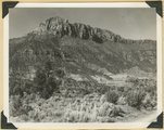 |
Smithsonian Butte from north base. Chinle, including Springdale member (middle ledge), Wingate? and Kayenta?, Navajo top. Washington County, UT | P0013 Herbert E. Gregory Photograph Collection | P0013n11_028_2568 |