Home
Browse
Ask Us
Chat
Harmful Language Statement
Log in
Photo Archives
Advanced Search
About
Over 90,000 photos covering a variety of topics from Marriott Library Special Collections.
Year
1930
1931
1932
1933
1934
1935
1936
1937
1938
TO
1930
1931
1932
1933
1934
1935
1936
1937
1938
Type
Image
12
Format
image/jpeg
12
Collection
Photo Archives
12
Filters:
Date:
"1937"
Spatial Coverage:
"Virgin River"
Type:
"Image"
1
-
25
of
12
Gallery view
Number of results to display per page
10
25
50
100
200
Sort by Relevance
Sort by Title A-Z
Sort by Title Z-A
Sort by Date Ascending
Sort by Date Descending
Sort by Last Modified Ascending
Sort by Last Modified Descending
Title
Date
Type
1
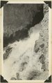
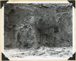
Cascade Falls, source of Virgin River. Point of emergence from Wasatch limestone. Garfield County, Utah, 1937.
1937
Image
2
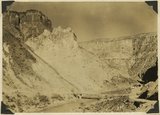
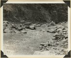
The Hurricane Fault where it crosses the Virgin River. La Verkin Warm Sulphur Springs in canyon.
1930; 1931; 1932; 1933; 1934; 1935; 1936; 1937
Image
3
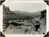
Site of Springdale, Virgin River Valley, below mouth of Zion Canyon. At left, the Watchman. Navajo sandstone, underlaid by Chinle: middle cliff is Springdale member. Washington County, UT
1937; 1938
Image
4
Source of the Virgin River. Looking northwest along Cascade Falls Trail. Spring issues from Wasatch limestone cliffs of Markagunt Plateau. Garfield County, Utah, 1937.
1937
Image
5
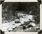
View of the Virgin River a few miles below the mouth of Zion Canyon, showing washed-out banks where farms once stood. Village of Grafton on the opposite side was once the center of a farming area.
1930; 1931; 1932; 1933; 1934; 1935; 1936; 1937
Image
6
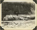
Virgin River at La Verkin Hot Springs. Shacks are shelters over intake pipes leading to the pool quarter of a mile down the river. Washington County, Utah, 1937.
1937
Image
7
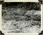
Virgin River in Zion National Park: erosion of land slide at flood stage
1937; 1938
Image
8
Virgin River in Zion National Park: flood stage
1937; 1938
Image
9
Virgin River in Zion National Park: flood stage
1937; 1938
Image
10
Virgin River in Zion National Park: rising flood from shower on Kolob Terrace
1937; 1938
Image
11
Virgin River in Zion National Park: rising flood from shower on Kolob Terrace
1937; 1938
Image
12
Wash of Virgin River at Grafton, 30 feet wide in 1860, now 1000 feet wide, Moenkopi forms banks, Navajo beyond, Washington County, Utah, 1930.
1930; 1931; 1932; 1933; 1934; 1935; 1936; 1937
Image
1
-
25
of
12