Over 90,000 photos covering a variety of topics from Marriott Library Special Collections.
| Title | Collection Number And Name | Photo Number | ||
|---|---|---|---|---|
| 1 | 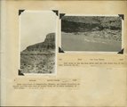 | Herbert E. Gregory Book 10: San Juan, Zion, Capitol Reef, 1915-1938 | P0013 Herbert E. Gregory Photograph Collection | P0013n10 |
| 2 | 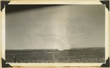 | View looking west toward Canaan Gap of Short Creek. Road on Arizona-Utah line; foreground, flat cut in lowest Chinle beds; background, cliffs and ridges of eastward dipping Shinarump overlying Moenkopi. Washington County, Utah, 1937. | P0013 Herbert E. Gregory Photograph Collection | P0013n10_171_2386 |
| 3 |  | Short Creek near village of Short Creek. Cutting of its channel 20-30 feet done since about 1885. Mohave County, Arizona, 1937. | P0013 Herbert E. Gregory Photograph Collection | P0013n10_172_2387 |
| 4 |  | Same as 799 (Short Creek near village of Short Creek. Cutting of its channel 20-30 feet done since about 1885. Mohave County, Arizona, 1937). Point of Vermillion Cliff in upper left. | P0013 Herbert E. Gregory Photograph Collection | P0013n10_172_2388 |
| 5 | 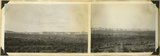 | Block mesas from the south, panorama. | P0013 Herbert E. Gregory Photograph Collection | P0013n10_174_2391 |
| 6 | 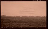 | Block mesas from south, panorama. | P0013 Herbert E. Gregory Photograph Collection | P0013n10_174_2391A |
| 7 |  | Plateau south of Block Mesas | P0013 Herbert E. Gregory Photograph Collection | P0013n10_176_2395 |
| 8 | 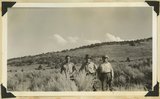 | Plateau south of Block mesas. Grantham, Stringham, and guide (right), 1937. | P0013 Herbert E. Gregory Photograph Collection | P0013n10_176_2395 |
| 9 | 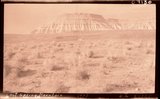 | Lost Spring Mountain, 1937. | P0013 Herbert E. Gregory Photograph Collection | P0013n10_177_2398 |
| 10 | 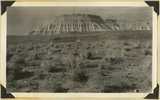 | Moenkopi capped by Shinarump, Lost Spring Mountain, 1937. | P0013 Herbert E. Gregory Photograph Collection | P0013n10_177_2398 |
| 11 |  | Squire Coop [5] | P0097 Salt Lake Oratorio Society photograph collection | P0097n02_02_181 |
| 12 | 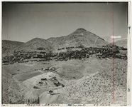 | Arizona, Jerome | P0244 Olive Woolley Burt Photograph Collection | P0244add1n3_01_0777 |
| 13 | 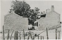 | First telegraph station in Arizona | P0244 Olive Woolley Burt Photograph Collection | P0244add1n3_01_0778 |
| 14 | 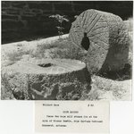 | Two mill stones located in Pipe Spring National Monument, Arizona | P0244 Olive Woolley Burt Photograph Collection | P0244add1n3_01_0779 |
| 15 | 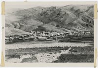 | Globe, copper mining town | P0244 Olive Woolley Burt Photograph Collection | P0244add1n3_11_0940 |
| 16 | 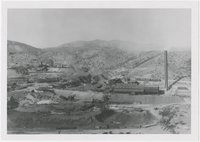 | Old Dominion smelter, Globe, Arizona | P0244 Olive Woolley Burt Photograph Collection | P0244add1n3_11_0942 |
| 17 | 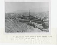 | Old Dominion copper smelter, early Globe, Arizona | P0244 Olive Woolley Burt Photograph Collection | P0244add1n3_11_0943 |
| 18 | 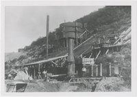 | Early smelter, Bisbee, Arizona | P0244 Olive Woolley Burt Photograph Collection | P0244add1n3_11_0945 |
| 19 |  | Brewery Gulch, early Bisbee, Arizona | P0244 Olive Woolley Burt Photograph Collection | P0244add1n3_11_0946 |
| 20 |  | Bit of Grand Canyon cornice work | P0244 Olive Woolley Burt Photograph Collection | P0244add1n3_11_0947 |
| 21 | 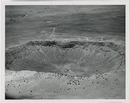 | Meteor Crater, Arizona | P0244 Olive Woolley Burt Photograph Collection | P0244add1n3_11_0948 |
| 22 |  | Bright Angel Trail, Grand Canyon | P0244 Olive Woolley Burt Photograph Collection | P0244add1n3_12_0961 |
| 23 | 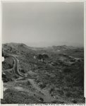 | Gold roads, mining camp & Hwy 66 near Oatman | P0244 Olive Woolley Burt Photograph Collection | P0244add1n3_15_1010 |
| 24 | 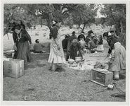 | People, Indians [32] | P0244 Olive Woolley Burt Photograph Collection | P0244add1n4_08_1222 |
| 25 |  | People, Indians [55] | P0244 Olive Woolley Burt Photograph Collection | P0244add1n4_08_1245 |