Home
Browse
Ask Us
Chat
Harmful Language Statement
Log in
Photo Archives
Advanced Search
About
Over 90,000 photos covering a variety of topics from Marriott Library Special Collections.
Year
1930
1931
1932
1933
1934
1935
1936
1937
TO
1930
1931
1932
1933
1934
1935
1936
1937
Type
Image
7
Format
image/jpeg
7
Collection
Photo Archives
7
Filters:
Date:
"1936"
Spatial Coverage:
"Virgin River"
Type:
"Image"
1
-
25
of
7
Gallery view
Number of results to display per page
10
25
50
100
200
Sort by Relevance
Sort by Title A-Z
Sort by Title Z-A
Sort by Date Ascending
Sort by Date Descending
Sort by Last Modified Ascending
Sort by Last Modified Descending
Title
Date
Type
1
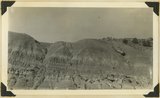
"Marls" in Chinle formation, Springdale, Washington County, Utah, 1936.
1936
Image
2
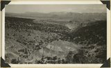
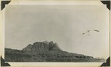
Grafton fault at west end of Smithsonian Butte, looking northward across Virgin River. Coalpits volcano in middle background, edge of Kolob plateau in distance. Washington County, Utah, 1936.
1936
Image
3
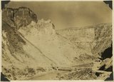
The Hurricane Fault where it crosses the Virgin River. La Verkin Warm Sulphur Springs in canyon.
1930; 1931; 1932; 1933; 1934; 1935; 1936; 1937
Image
4
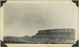
Moenkopi capped by Shinarump. Coalpits volcano in distance. Virgin River in foreground. Rockville, Washington County, Utah, 1936.
1936
Image
5
View looking north across Virgin River at Rockville. Foreground, Moenkopi capped by Shinarump; middle distance, Chinle; distance, Navajo forming Mount Kinesava. Washington County, Utah, 1936.
1936
Image
6
View of the Virgin River a few miles below the mouth of Zion Canyon, showing washed-out banks where farms once stood. Village of Grafton on the opposite side was once the center of a farming area.
1930; 1931; 1932; 1933; 1934; 1935; 1936; 1937
Image
7
Wash of Virgin River at Grafton, 30 feet wide in 1860, now 1000 feet wide, Moenkopi forms banks, Navajo beyond, Washington County, Utah, 1930.
1930; 1931; 1932; 1933; 1934; 1935; 1936; 1937
Image
1
-
25
of
7