Over 70,000 photos covering a variety of topics from Marriott Library Special Collections
TO
Filters: Date: "1936" Collection: "uum_map"
| Title | Collection Number And Name | Photo Number | ||
|---|---|---|---|---|
| 501 |
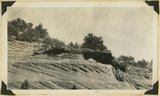 |
Wingate sandstone. Three Lakes Canyon, Kane County, Utah, 1936. | P0013 Herbert E. Gregory Photograph Collection | P0013n10_136_2320 |
| 502 |
 |
Wingate sandstone overlaid by Kayenta formation, Cave Lakes Canyon, Kane County, Utah, 1936. | P0013 Herbert E. Gregory Photograph Collection | P0013n10_136_2321 |
| 503 |
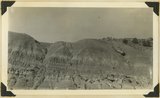 |
"Marls" in Chinle formation, Springdale, Washington County, Utah, 1936. | P0013 Herbert E. Gregory Photograph Collection | P0013n10_137_2322 |
| 504 |
 |
"Marls" in Chinle formation. Above them the Springdale member of Chinle, Springdale, Washington County, Utah, 1936. | P0013 Herbert E. Gregory Photograph Collection | P0013n10_138_2323 |
| 505 |
 |
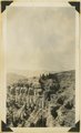
Upper part of Chinle formation. "Marls" in foreground. Near Kanab, Kane County, Utah, 1936. | P0013 Herbert E. Gregory Photograph Collection | P0013n10_138_2324 |
| 506 |
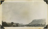 |
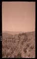
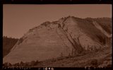
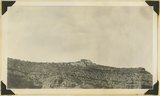
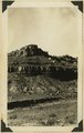
Mesas of Moenkopi capped by Shinarump. Virgin River looking downstream at Rockville, Washington County, Utah, 1936. | P0013 Herbert E. Gregory Photograph Collection | P0013n10_139_2325 |
| 507 |
 |
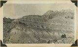
Looking north along Sevier fault at Orderville. Right, Carmel and Navajo; left, Straight Cliffs formation (Crfetaceous). Kane County, Utah, 1936. | P0013 Herbert E. Gregory Photograph Collection | P0013n10_139_2326 |
| 508 |
 |
Straight Cliffs, Tropic shale and Wahweap sandstones (Cretaceous), head of La Verkin Creek, Washington County, Utah, 1936. | P0013 Herbert E. Gregory Photograph Collection | P0013n10_140_2327 |
| 509 |
 |
Carmel limestone, Mt. Carmel Junction, 1936. | P0013 Herbert E. Gregory Photograph Collection | P0013n10_140_2328 |
| 510 |
 |
Mt. Carmel Junc. | P0013 Herbert E. Gregory Photograph Collection | P0013n10_140_2328 |
| 511 |
 |
Near Rockville | P0013 Herbert E. Gregory Photograph Collection | P0013n10_140_2329 |
| 512 |
 |
Upper Moenkopi capped by Shinarump near Rockville, 1936. | P0013 Herbert E. Gregory Photograph Collection | P0013n10_140_2329 |
| 513 |
 |
Chinle "marls" Springdale, 1936. | P0013 Herbert E. Gregory Photograph Collection | P0013n10_141_2330 |
| 514 |
 |
Springdale | P0013 Herbert E. Gregory Photograph Collection | P0013n10_141_2330 |
| 515 |
 |
Kanab Canyon | P0013 Herbert E. Gregory Photograph Collection | P0013n10_141_2331 |
| 516 |
 |
Wingate sandstone, Kanab Canyon, 1936. | P0013 Herbert E. Gregory Photograph Collection | P0013n10_141_2331 |
| 517 |
 |
E. Kanab | P0013 Herbert E. Gregory Photograph Collection | P0013n10_142_2332 |
| 518 |
 |
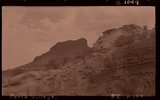
Top of Chinle, Wingate in background, E. Kanab, 1936. | P0013 Herbert E. Gregory Photograph Collection | P0013n10_142_2332 |
| 519 |
 |
Kolob Plateau | P0013 Herbert E. Gregory Photograph Collection | P0013n10_142_2333 |
| 520 |
 |
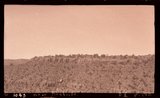
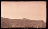
Kolob plateau, general surface. Pink cliffs in background, 1936. | P0013 Herbert E. Gregory Photograph Collection | P0013n10_142_2333 |
| 521 |
 |
Paria Village | P0013 Herbert E. Gregory Photograph Collection | P0013n10_143_2334 |
| 522 |
 |
Unconformity Moenkopi-Shinarump west Paria village, 1936. | P0013 Herbert E. Gregory Photograph Collection | P0013n10_143_2334 |
| 523 |
 |
Upper Moenkopi Shanabkaib member at base showing sandstone ledge, Shinarump at top, Rockville, Washington County, Utah, 1936. | P0013 Herbert E. Gregory Photograph Collection | P0013n10_143_2335 |
| 524 |
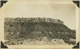 |
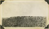
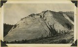
Moenkopi (upper two-thirds) overlaid by Shinarump 2 miles west of Rockville, Washington County, Utah, 1936. | P0013 Herbert E. Gregory Photograph Collection | P0013n10_143_2336 |
| 525 |
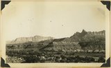 |
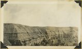
Looking southeast across Rockville, Moenkopi (at river), Shinarump (mesa caps), Chinle (broken slopes), Navajo (top), showing Eagle Crag (right), and South Mountain (left), Washington County, Utah, 1936. | P0013 Herbert E. Gregory Photograph Collection | P0013n10_144_2337 |