| Title | Date | Type | Setname | ||
|---|---|---|---|---|---|
| 1 | 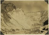 | The Hurricane Fault where it crosses the Virgin River. La Verkin Warm Sulphur Springs in canyon. | 1930; 1931; 1932; 1933; 1934; 1935; 1936; 1937 | Image | uum_map |
| 2 | 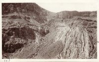 | Hurricane Fault, at Intersection of Virgin River | 1907; 1908; 1909; 1910; 1911; 1912; 1913; 1914; 1915; 1916; 1917; 1918; 1919; 1920; 1921; 1922; 1923; 1924; 1925; 1926; 1927; 1928; 1929; 1930; 1931; 1932; 1933; 1934; 1935 | Image/StillImage | uum_map |
| 3 |  | View of the Virgin River a few miles below the mouth of Zion Canyon, showing washed-out banks where farms once stood. Village of Grafton on the opposite side was once the center of a farming area. | 1930; 1931; 1932; 1933; 1934; 1935; 1936; 1937 | Image | uum_map |
| 4 |  | Virgin River - East of Fault Scarp | 1908; 1909; 1910; 1911; 1912; 1913; 1914; 1915; 1916; 1917; 1918; 1919; 1920; 1921; 1922; 1923; 1924; 1925; 1926; 1927; 1928; 1929; 1930; 1931; 1932; 1933; 1934; 1935 | Image/StillImage | uum_map |
| 5 |  | Virgin River from bridge at Mesquite, Nevada | 1907; 1908; 1909; 1910; 1911; 1912; 1913; 1914; 1915; 1916; 1917; 1918; 1919; 1920; 1921; 1922; 1923; 1924; 1925; 1926; 1927; 1928; 1929; 1930; 1931; 1932; 1933; 1934; 1935 | Image/StillImage | uum_map |
| 6 | 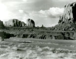 | Virgin River p. 4 | 1930; 1931; 1932; 1933; 1934; 1935; 1936; 1937; 1938; 1939; 1940; 1941; 1942; 1943 | Image/StillImage | dha_cp |
| 7 |  | Wash of Virgin River at Grafton, 30 feet wide in 1860, now 1000 feet wide, Moenkopi forms banks, Navajo beyond, Washington County, Utah, 1930. | 1930; 1931; 1932; 1933; 1934; 1935; 1936; 1937 | Image | uum_map |
| 8 | 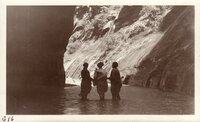 | Zion tour, late 1920s, early 1930s: Zion Canyon - Nellie - Mrs Kimball - Ethel Waddoups | 1925; 1926; 1927; 1928; 1929; 1930; 1931; 1932; 1933; 1934; 1935 | Image/StillImage | uum_map |