|
|
Title | Collection Number And Name | Photo Number |
| 101 |
 |
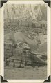
Old abandoned cotton mill at Washington, Utah. | P0013 Herbert E. Gregory Photograph Collection | P0013n10_062_2194 |
| 102 |
 |
View of the Virgin River a few miles below the mouth of Zion Canyon, showing washed-out banks where farms once stood. Village of Grafton on the opposite side was once the center of a farming area. | P0013 Herbert E. Gregory Photograph Collection | P0013n10_063_2195 |
| 103 |
 |
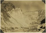
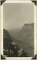
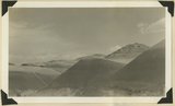
View from the top of the Hurricane Fault (La Verkin Hill), showing Pine Valley Mountain in the distance; the Vermillion Cliff formation in the middle distance, which is the same formation as Zion only much lower on the west side of the Hurricane Fault. | P0013 Herbert E. Gregory Photograph Collection | P0013n10_063_2196 |
| 104 |
 |
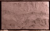
View of a branch of the Hurricane Fault showing tilted block on the left which tipped over between the forks with the main fault. Visible from highway at the summit of La Verkin Hill. Lava flow on top and sides of tilted block on left side of picture. | P0013 Herbert E. Gregory Photograph Collection | P0013n10_064_2197 |
| 105 |
 |
The Hurricane Fault where it crosses the Virgin River. La Verkin Warm Sulphur Springs in canyon. | P0013 Herbert E. Gregory Photograph Collection | P0013n10_064_2198 |
| 106 |
 |
Shale formation where fossils are found. Near the Pine Creek bridge at the base of the switchboard on new Mt. Carmel road, Zion Canyon. | P0013 Herbert E. Gregory Photograph Collection | P0013n10_065_2199 |
| 107 |
 |
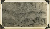
The Virgin Mesa from top of Hurricane Hill. | P0013 Herbert E. Gregory Photograph Collection | P0013n10_066_2200 |
| 108 |
 |
Virgin Mesa from highway below Rockville, Utah. | P0013 Herbert E. Gregory Photograph Collection | P0013n10_066_2201 |
| 109 |
 |
Crossbedding of sandstone along Mt. Carmel road. Indicating wind action and sand dune formation prior to the formation of rock. | P0013 Herbert E. Gregory Photograph Collection | P0013n10_067_2202 |
| 110 |
 |
Curvillinear fractures in sandstone, west wall of Temple of Sinawava, Zion Canyon. | P0013 Herbert E. Gregory Photograph Collection | P0013n10_068_2203 |
| 111 |
 |
Wind and water erosion in sandstone. In Zion Canyon on west side of the Virgin River, about one-half mile above checking station. | P0013 Herbert E. Gregory Photograph Collection | P0013n10_069_2204 |
| 112 |
 |
Half Arch. East side of Narrows, Zion Canyon, above Temple of Sinawava. | P0013 Herbert E. Gregory Photograph Collection | P0013n10_070_2205 |
| 113 |
 |
Hidden Canyon from Observation Point. A typical hanging canyon or valley. | P0013 Herbert E. Gregory Photograph Collection | P0013n10_071_2206 |
| 114 |
 |
Volcanic cone, two miles west of Hurricane, Utah. | P0013 Herbert E. Gregory Photograph Collection | P0013n10_071_2207 |
| 115 |
 |
Lava flow over gravel wash. South of Toquerville, Utah, along main road from Zion Canyon to Anderson's Ranch. | P0013 Herbert E. Gregory Photograph Collection | P0013n10_072_2208 |
| 116 |
 |
View southwest toward the rim of Bryce Canyon from the north side of lower canyon near the Fairy Temple trail. | P0013 Herbert E. Gregory Photograph Collection | P0013n10_074_2209 |
| 117 |
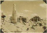 |
View east toward Seal Castle and Fairy Temple. "Lot's wife" in the foreground. | P0013 Herbert E. Gregory Photograph Collection | P0013n10_075_2210 |
| 118 |
 |
Shonesburg Gulch, branch of Parunumeap Canyon, Line Fold trail, Rockville to Mt. Carmel. Navajo sandstone underlaid by Kyenta and Chinle. Washington County, Utah, 1935. | P0013 Herbert E. Gregory Photograph Collection | P0013n10_130_2308 |
| 119 |
 |
Capitol Reef wash, cut in Navajo sandstone, Wayne County, Utah, 1935. | P0013 Herbert E. Gregory Photograph Collection | P0013n10_131_2310 |
| 120 |
 |
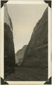
Lower part of wall of "Grand Gulch," Moenkopi, Chinle and Wingate strata. Wayne County, Utah, 1935. | P0013 Herbert E. Gregory Photograph Collection | P0013n10_132_2311 |
| 121 |
 |
[Grand Gulch, Wayne Co., Ut.] | P0013 Herbert E. Gregory Photograph Collection | P0013n10_132_2312 |
| 122 |
 |
Wall of "Grand Gulch," Moenkopi, Chinle and Wingate strata. Wayne County, Utah, 1935. | P0013 Herbert E. Gregory Photograph Collection | P0013n10_132_2312 |
| 123 |
 |
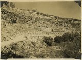
Mounds developed in Cretaceous (Tropic shale?) east of Notum Ranch. Wayne County, Utah, 1935. | P0013 Herbert E. Gregory Photograph Collection | P0013n10_133_2313 |
| 124 |
 |
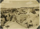
Table Cliff Plateau, looking northeast from Bryce Point. Paria River and town of Tropic in middle distance. Bryce National Park, Utah, 1935. | P0013 Herbert E. Gregory Photograph Collection | P0013n10_207_2461 |
| 125 |
 |
Basalt in Moenkopi, north wash. | P0013 Herbert E. Gregory Photograph Collection | P0013n10_217_2479 |