Over 70,000 photos covering a variety of topics from Marriott Library Special Collections
TO
| Title | Collection Number And Name | Photo Number | ||
|---|---|---|---|---|
| 526 |
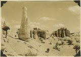 |
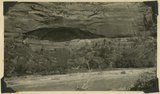
View east toward Seal Castle and Fairy Temple. "Lot's wife" in the foreground. | P0013 Herbert E. Gregory Photograph Collection | P0013n10_075_2210 |
| 527 |
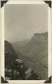 |
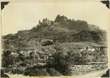
Shonesburg Gulch, branch of Parunumeap Canyon, Line Fold trail, Rockville to Mt. Carmel. Navajo sandstone underlaid by Kyenta and Chinle. Washington County, Utah, 1935. | P0013 Herbert E. Gregory Photograph Collection | P0013n10_130_2308 |
| 528 |
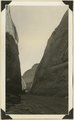 |
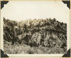
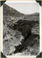
Capitol Reef wash, cut in Navajo sandstone, Wayne County, Utah, 1935. | P0013 Herbert E. Gregory Photograph Collection | P0013n10_131_2310 |
| 529 |
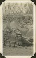 |
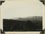
Lower part of wall of "Grand Gulch," Moenkopi, Chinle and Wingate strata. Wayne County, Utah, 1935. | P0013 Herbert E. Gregory Photograph Collection | P0013n10_132_2311 |
| 530 |
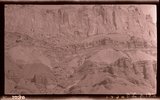 |
[Grand Gulch, Wayne Co., Ut.] | P0013 Herbert E. Gregory Photograph Collection | P0013n10_132_2312 |
| 531 |
 |
Wall of "Grand Gulch," Moenkopi, Chinle and Wingate strata. Wayne County, Utah, 1935. | P0013 Herbert E. Gregory Photograph Collection | P0013n10_132_2312 |
| 532 |
 |
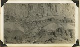
Mounds developed in Cretaceous (Tropic shale?) east of Notum Ranch. Wayne County, Utah, 1935. | P0013 Herbert E. Gregory Photograph Collection | P0013n10_133_2313 |
| 533 |
 |
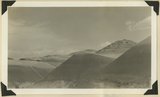
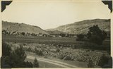
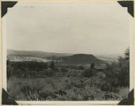
Table Cliff Plateau, looking northeast from Bryce Point. Paria River and town of Tropic in middle distance. Bryce National Park, Utah, 1935. | P0013 Herbert E. Gregory Photograph Collection | P0013n10_207_2461 |
| 534 |
 |
Basalt in Moenkopi, north wash. | P0013 Herbert E. Gregory Photograph Collection | P0013n10_217_2479 |
| 535 |
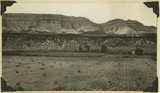 |
Elkheart Cliffs east of Mt. Carmel. | P0013 Herbert E. Gregory Photograph Collection | P0013n10_218_2480 |
| 536 |
 |
Same as 191 (Looking north across Orderville, Sevier fault), taken nearer Orderville. | P0013 Herbert E. Gregory Photograph Collection | P0013n10_218_2481 |
| 537 |
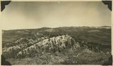 |
View NE across head of Kanab valley. Left, tilted Tertiary west of Sevier fault; right, Alton Cirque (lowland), above it, Pink Cliffs. | P0013 Herbert E. Gregory Photograph Collection | P0013n10_219_2482 |
| 538 |
 |
West edge Kolob plateau from New Harmony road. | P0013 Herbert E. Gregory Photograph Collection | P0013n10_219_2483 |
| 539 |
 |
One of "Three Lakes," Kanab Canyon. | P0013 Herbert E. Gregory Photograph Collection | P0013n10_220_2484 |
| 540 |
 |
Cliff dweller niche, base of Navajo sandstone. Zion Park. | P0013 Herbert E. Gregory Photograph Collection | P0013n10_221_2486 |
| 541 |
 |
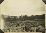
Eagle Crags. | P0013 Herbert E. Gregory Photograph Collection | P0013n10_221_2487 |
| 542 |
 |
Carmel on Navajo. Head of Parunuweap Canyon. | P0013 Herbert E. Gregory Photograph Collection | P0013n10_223_2488 |
| 543 |
 |
Coalpits volcano north of Grafton. | P0013 Herbert E. Gregory Photograph Collection | P0013n10_223_2489 |
| 544 |
 |
Volcano on Kolob plateau. | P0013 Herbert E. Gregory Photograph Collection | P0013n10_223_2490 |
| 545 |
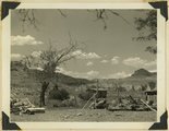 |
Remains of old town of Paria. | P0013 Herbert E. Gregory Photograph Collection | P0013n10_224_2491 |
| 546 |
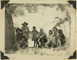 |
Mangum family with Herbert E. Gregory, Paria. | P0013 Herbert E. Gregory Photograph Collection | P0013n10_224_2492 |
| 547 |
 |
Tent Buttes, Straight Cliffs sandstone, east side Clear Creek Mountain. Kane County, UT, 1935 | P0013 Herbert E. Gregory Photograph Collection | P0013n11_019_2553 |
| 548 |
 |
Gully out into alluvium 15-25 feet since 1925 (?). Meadow Brook. Kane County, UT, 1935 | P0013 Herbert E. Gregory Photograph Collection | P0013n11_019_2554 |
| 549 |
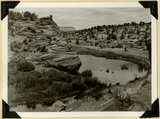 |
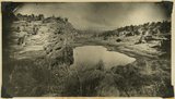
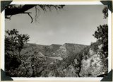
Upper Lake and part of Middle Lake in Three Lakes Canyon, base of Navajo sandstone. White Cliffs in distance. Kane County, UT | P0013 Herbert E. Gregory Photograph Collection | P0013n11_020_2555 |
| 550 |
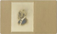 |
Joseph T. Kingsbury | P0029 Joseph Kingsbury Photograph Collection | P0029n01_10_02 |