Over 70,000 photos covering a variety of topics from Marriott Library Special Collections
TO
1 - 25 of 3
| Title | Date | Type | ||
|---|---|---|---|---|
| 1 |
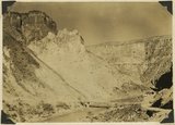 |
The Hurricane Fault where it crosses the Virgin River. La Verkin Warm Sulphur Springs in canyon. | 1930; 1931; 1932; 1933; 1934; 1935; 1936; 1937 | Image |
| 2 |
 |
View of the Virgin River a few miles below the mouth of Zion Canyon, showing washed-out banks where farms once stood. Village of Grafton on the opposite side was once the center of a farming area. | 1930; 1931; 1932; 1933; 1934; 1935; 1936; 1937 | Image |
| 3 |
 |
Wash of Virgin River at Grafton, 30 feet wide in 1860, now 1000 feet wide, Moenkopi forms banks, Navajo beyond, Washington County, Utah, 1930. | 1930; 1931; 1932; 1933; 1934; 1935; 1936; 1937 | Image |
1 - 25 of 3