|
|
Title | Collection Number And Name | Photo Number |
| 126 |
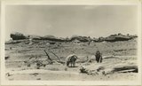 |
View at mouth of Fish Creek. Supai with cap of attenuated Coconino (?) or sandstone in Supai(?). San Juan County, UT, 1927 | P0013 Herbert E. Gregory Photograph Collection | P0013n09_077_1868 |
| 127 |
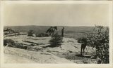 |
Looking into Road Canyon from old Mormon Road from Clay Hills to Bluff. Coconino cap rock. San Juan County, UT, 1927 | P0013 Herbert E. Gregory Photograph Collection | P0013n09_078_1869 |
| 128 |
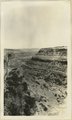 |
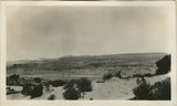
Fish Canyon near its head. Coconino(?) over Supai(?). Comb monocline in the distance. San Juan County, UT, 1927 | P0013 Herbert E. Gregory Photograph Collection | P0013n09_078_1870 |
| 129 |
 |
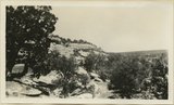
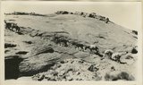
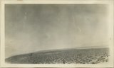
Surface of Grand Gulch plateau near Snow Flat. Coconino(?) sandstone, San Juan County, 1927 | P0013 Herbert E. Gregory Photograph Collection | P0013n09_079_1871 |
| 130 |
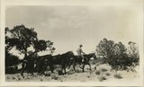 |
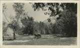
View at Snow Flat head of Fish Creek. San Juan County, UT, 1927 | P0013 Herbert E. Gregory Photograph Collection | P0013n09_079_1872 |
| 131 |
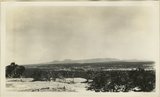 |
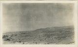
Grand Gulch Plateau near head of Fish Creek, toward Elk Ridge. San Juan County, UT, 1927 | P0013 Herbert E. Gregory Photograph Collection | P0013n09_080_1873 |
| 132 |
 |
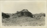
Butte of Moenkopi standing on Coconino(?) between Snow Flat and Kane Draw. San Juan County, UT, 1927 | P0013 Herbert E. Gregory Photograph Collection | P0013n09_080_1874 |
| 133 |
 |
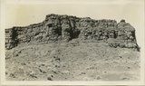
Top of Coconino(?) at head of Kane Draw tributary to Grand Gulch. San Juan County, 1927 | P0013 Herbert E. Gregory Photograph Collection | P0013n09_081_1875 |
| 134 |
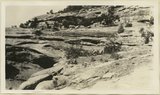 |
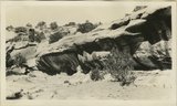
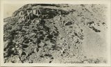
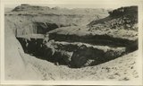
Coconino(?) at Dripping Springs, Grand Gulch, showing irregular bedding caused by lenses of red shale. San Juan County, UT, 1927 | P0013 Herbert E. Gregory Photograph Collection | P0013n09_081_1876 |
| 135 |
 |
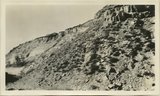
Coconino on rim of Grand Gulch near Dripping Springs. Recession of cliff along thin bed of red shale. Cliff rim under cliff. San Juan County, UT, 1927 | P0013 Herbert E. Gregory Photograph Collection | P0013n09_082_1877 |
| 136 |
 |
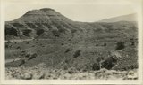
Moenkopi Cliff. 4 miles north of Clay Hills Divide. Top is massive wall 100 feet high. San Juan County, UT, 1927 | P0013 Herbert E. Gregory Photograph Collection | P0013n09_082_1878 |
| 137 |
 |
Middle Moenkopi near Clay Hills Divide. "Organ" weathering. San Juan County, UT. 1927 | P0013 Herbert E. Gregory Photograph Collection | P0013n09_083_1879 |
| 138 |
 |
Upper Moenkopi near Clay Hills Divide. Shinarump cap. San Juan County, UT, 1927 | P0013 Herbert E. Gregory Photograph Collection | P0013n09_083_1880 |
| 139 |
 |
Looking east across Castle Wash at the point where old Mormon Road leaves the wash to go to Lake Canyon. San Juan County, UT, 1927 | P0013 Herbert E. Gregory Photograph Collection | P0013n09_084_1881 |
| 140 |
 |
Camp in Lake Canyon. Walls of Navajo Sandstone. San Juan County, UT, 1927 | P0013 Herbert E. Gregory Photograph Collection | P0013n09_084_1882 |
| 141 |
 |
Lacustrine deposits in Lake Canyon at former "Lake." San Juan County, UT, 1927 | P0013 Herbert E. Gregory Photograph Collection | P0013n09_085_1883 |
| 142 |
 |
Lacustrine deposits in Lake Canyon at former "Lake." San Juan County, UT, 1927 | P0013 Herbert E. Gregory Photograph Collection | P0013n09_085_1884 |
| 143 |
 |
Trail up face of Gray Mesa, Navajo sandstone. San Juan County, UT, 1927 | P0013 Herbert E. Gregory Photograph Collection | P0013n09_086_1885 |
| 144 |
 |
Gray Mesa toward south end of Waterpocket fold. San Juan County, UT, 1927 | P0013 Herbert E. Gregory Photograph Collection | P0013n09_086_1886 |
| 145 |
 |
Carmel overlying Navajo Gray Mesa. San Juan County, UT, 1927 | P0013 Herbert E. Gregory Photograph Collection | P0013n09_087_1887 |
| 146 |
 |
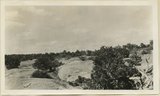
Navajo sandstone at Junction of Colorado and San Juan Rivers, San Juan County, UT, 1927 | P0013 Herbert E. Gregory Photograph Collection | P0013n09_087_1888 |
| 147 |
 |
Navajo sandstone at Junction of Colorado and San Juan Rivers, San Juan County, UT, 1927 | P0013 Herbert E. Gregory Photograph Collection | P0013n09_088_1889 |
| 148 |
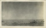 |
San Juan Canyon from near its mouth. San Juan County, UT, 1927 | P0013 Herbert E. Gregory Photograph Collection | P0013n09_088_1890 |
| 149 |
 |
Top of Wilson Mesa, Navajo Mountain at left; Kaiparowits plateau at right background. San Juan County, UT, 1927 | P0013 Herbert E. Gregory Photograph Collection | P0013n09_089_1891 |
| 150 |
 |
Moki Canyon trail down sand dunes near Red Cove Spring. Wingate, Todilto, Navajo. San Juan County, UT, 1927 | P0013 Herbert E. Gregory Photograph Collection | P0013n09_089_1892 |