|
|
Title | Collection Number And Name | Photo Number |
| 326 |
 |
Banded shales with 3 beds of gypsum, 'Marine Jurassic,' Cottonwood Wash section. Kane County, UT, 1924 | P0013 Herbert E. Gregory Photograph Collection | P0013n09_006_1732 |
| 327 |
 |
Contact McElmo and Dakota, Henrieville Wash. Garfield County, UT, 1924 | P0013 Herbert E. Gregory Photograph Collection | P0013n09_007_1733 |
| 328 |
 |
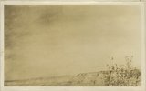
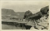
Cannonville, UT, looking east. September, 1924 | P0013 Herbert E. Gregory Photograph Collection | P0013n09_007_1734 |
| 329 |
 |
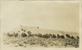
Vegetation (pinion, cedar) in shales just above Navajo sandstone, Cottonwood Wash, Kane County, UT, 1924 | P0013 Herbert E. Gregory Photograph Collection | P0013n09_008_1735 |
| 330 |
 |
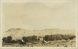
General view upper two thirds Waweap beds 1 mile southwest of Cannonville, Garfield County, UT 1924 | P0013 Herbert E. Gregory Photograph Collection | P0013n09_008_1736 |
| 331 |
 |
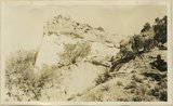
Detail view showing change in massiveness of beds of Waweap formation. along strike. Cannonville, Garfield County, UT, 1924 | P0013 Herbert E. Gregory Photograph Collection | P0013n09_009_1737 |
| 332 |
 |
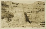
Yellow-red sandstone above gypsiferous shales, Waweap formation 3 miles SE of Cannonville. Equivalent of beds shown in photograph 1728. Garfield County, UT 1924 | P0013 Herbert E. Gregory Photograph Collection | P0013n09_009_1738 |
| 333 |
 |
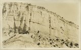
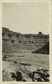
Cliffs of Waweap capped with Dakota. East side Dry Valley looking North. Top of Kaiparowits Plateau in distance. Kane County, UT. 1924 | P0013 Herbert E. Gregory Photograph Collection | P0013n09_010_1739 |
| 334 |
 |
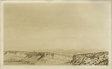
General view walls of Dry Valley, Kane County, UT 1924 | P0013 Herbert E. Gregory Photograph Collection | P0013n09_010_1740 |
| 335 |
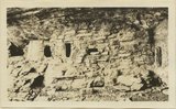 |
Cliff House, Fable Valley (Fred Lowrey, Honolulu) | P0013 Herbert E. Gregory Photograph Collection | P0013n09_145_1996 |
| 336 |
 |
Cliff House, Fable Valley (Fred Lowrey, Honolulu) | P0013 Herbert E. Gregory Photograph Collection | P0013n09_145_1997 |
| 337 |
 |
Cliff House, Fable Valley (Fred Lowrey, Honolulu) | P0013 Herbert E. Gregory Photograph Collection | P0013n09_145_1998 |
| 338 |
 |
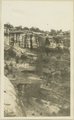
Survey headquarters, Blanding, UT. Lowrey | P0013 Herbert E. Gregory Photograph Collection | P0013n09_145_1999 |
| 339 |
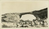 |
Edwin Bridge, White Canyon (Prof. L.M. Gould, University of Michigan, 1924.) | P0013 Herbert E. Gregory Photograph Collection | P0013n09_146_2000 |
| 340 |
 |
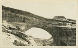
Caroline Bridge, White Canyon, 1924 | P0013 Herbert E. Gregory Photograph Collection | P0013n09_146_2001 |
| 341 |
 |
Augusta Bridge, White Canyon, 1924 | P0013 Herbert E. Gregory Photograph Collection | P0013n09_147_2002 |
| 342 |
 |
Waterfall after showers, White Canyon | P0013 Herbert E. Gregory Photograph Collection | P0013n09_147_2003 |
| 343 |
 |
Wall of White Canyon, M. L. Gould, 1924, | P0013 Herbert E. Gregory Photograph Collection | P0013n09_148_2004 |
| 344 |
 |
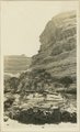
View of Allen Canyon country. Winter and summer Hogan, Piute Indians | P0013 Herbert E. Gregory Photograph Collection | P0013n09_149_2005 |
| 345 |
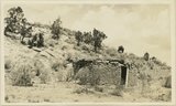 |
Rock house, Piutes. Allen Canyon, L. M. Gould, 1924 | P0013 Herbert E. Gregory Photograph Collection | P0013n09_149_2006 |
| 346 |
 |
San Juan River between narrows and mouth of Chinle, U. S. G. S., Miser, 418 | P0013 Herbert E. Gregory Photograph Collection | P0013n09_151_2007 |
| 347 |
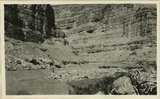 |
San Juan Canyon between Honoker trail and Johns Canyon, Goodridge formation, Miser | P0013 Herbert E. Gregory Photograph Collection | P0013n09_152_2008 |
| 348 |
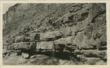 |
San Juan Canyon at mouth of Grand Gulch. Goodridge, Moonlight, and Hermit formations, Miser | P0013 Herbert E. Gregory Photograph Collection | P0013n09_152_2009 |
| 349 |
 |
Red House in Red Canyon, U. S. G. S., Miser, 448 | P0013 Herbert E. Gregory Photograph Collection | P0013n09_153_2010 |
| 350 |
 |
Sand Flat Skewer Camp, San Juan River | P0013 Herbert E. Gregory Photograph Collection | P0013n09_153_2011 |