| Title | Date | Type | Setname | ||
|---|---|---|---|---|---|
| 551 |
 |
Addleman, J. F. (child) | 1920; 1921; 1922; 1923; 1924; 1925; 1926; 1927; 1928; 1929; 1930 | Image/StillImage | dha_crscpc |
| 552 |
 |
Adkinson, Mrs. Robt. | 1920; 1921; 1922; 1923; 1924; 1925; 1926; 1927; 1928; 1929; 1930 | Image/StillImage | dha_crscpc |
| 553 |
 |
Administration Building of the Church of Jesus Christ of Latter Day Saints | 1920; 1921; 1922; 1923; 1924; 1925; 1926; 1927; 1928; 1929; 1930; 1931; 1932; 1933; 1934; 1935; 1936; 1937; 1938; 1939; 1940 | uum_map | |
| 554 |
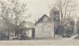 |
Adventist Church, 600 East 500 South. | 1900; 1901; 1902; 1903; 1904; 1905; 1906; 1907; 1908; 1909; 1910; 1911; 1912; 1913; 1914; 1915; 1916; 1917; 1918; 1919; 1920; 1921; 1922; 1923; 1924; 1925; 1926; 1927; 1928; 1929 | Image | uum_map |
| 555 |
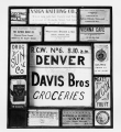 |
Advertisements in a window for grocery stores, restaurants, feed stores, pharmacies and other businesses circa 1920-1930s. | 1920; 1921; 1922; 1923; 1924; 1925; 1926; 1927; 1928; 1929; 1930; 1931; 1932; 1933; 1934; 1935; 1936; 1937; 1938; 1939 | Image | uum_map |
| 556 |
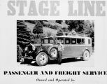 |
Advertizement for a stage line running up and down Big Cottonwood Canyon. | 1920; 1921; 1922; 1923; 1924; 1925; 1926; 1927; 1928; 1929 | Image | uum_map_usa |
| 557 |
 |
Aerial view from Exchange Place towards Capitol on Main Street (Sainsbury, photo) (negative) 1910-1930 | 1910; 1911; 1912; 1913; 1914; 1915; 1916; 1917; 1918; 1919; 1920; 1921; 1922; 1923; 1924; 1925; 1926; 1927; 1928; 1929; 1930 | Image/StillImage | uum_map |
| 558 |
 |
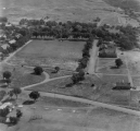
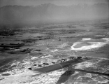
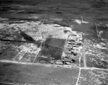
Aerial view of farmland. | 1920; 1921; 1922; 1923; 1924; 1925; 1926; 1927; 1928; 1929; 1930; 1931; 1932; 1933; 1934; 1935; 1936; 1937; 1938; 1939 | Image | uum_map |
| 559 |
 |
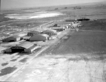
Aerial view of Fort Douglas. | 1920; 1921; 1922; 1923; 1924; 1925; 1926; 1927; 1928; 1929; 1930; 1931; 1932; 1933; 1934; 1935; 1936; 1937; 1938; 1939 | Image | uum_map |
| 560 |
 |
Aerial view of Fort Douglas. | 1920; 1921; 1922; 1923; 1924; 1925; 1926; 1927; 1928; 1929; 1930; 1931; 1932; 1933; 1934; 1935; 1936; 1937; 1938; 1939 | Image | uum_map |
| 561 |
 |
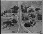
Aerial view of Helper, circa 1920. Published by A. J. Stafford. | 1915; 1916; 1917; 1918; 1919; 1920; 1921; 1922; 1923; 1924; 1925 | Image | uum_map |
| 562 |
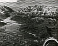 |
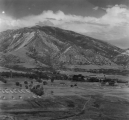
Aerial view of Mt. Timpanogos | 1920; 1921; 1922; 1923; 1924; 1925; 1926; 1927; 1928; 1929; 1930; 1931; 1932; 1933; 1934; 1935; 1936; 1937; 1938; 1939; 1940; 1941; 1942; 1943; 1944; 1945; 1946; 1947; 1948; 1949; 1950; 1951; 1952; 1953; 1954; 1955; 1956; 1957; 1958; 1959; 1960 | uum_map_usa | |
| 563 |
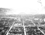 |
Aerial view of Salt Lake City [1] | 1920; 1921; 1922; 1923; 1924; 1925; 1926; 1927; 1928; 1929; 1930; 1931; 1932; 1933; 1934; 1935; 1936; 1937; 1938; 1939 | Image | uum_map |
| 564 |
 |
Aerial view of Salt Lake City [7] | 1910; 1911; 1912; 1913; 1914; 1915; 1916; 1917; 1918; 1919; 1920; 1921; 1922; 1923; 1924; 1925; 1926; 1927; 1928; 1929; 1930; 1931; 1932; 1933; 1934; 1935; 1936; 1937; 1938; 1939 | Image | uum_map |
| 565 |
 |
Aerial view of Saltair. | 1910; 1911; 1912; 1913; 1914; 1915; 1916; 1917; 1918; 1919; 1920; 1921; 1922; 1923; 1924; 1925; 1926; 1927; 1928; 1929 | Image | uum_map |
| 566 |
 |
Aerial view of Stockton | 1920; 1921; 1922; 1923; 1924; 1925; 1926; 1927; 1928; 1929; 1930; 1931; 1932; 1933; 1934; 1935; 1936; 1937; 1938; 1939; 1940 | Image/StillImage | dha_rucc |
| 567 |
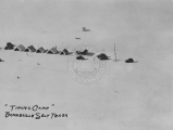 |
Aerial view of the "Timing Camp" on the Bonneville Salt Flats Raceway circa 1920s-1930s. | 1920; 1921; 1922; 1923; 1924; 1925; 1926; 1927; 1928; 1929; 1930; 1931; 1932; 1933; 1934; 1935; 1936; 1937; 1938; 1939 | Image | uum_map |
| 568 |
 |
Aerial view of the Bonneville Salt Flats Raceway circa 1920s-1930s. | 1920; 1921; 1922; 1923; 1924; 1925; 1926; 1927; 1928; 1929; 1930; 1931; 1932; 1933; 1934; 1935; 1936; 1937; 1938; 1939 | Image | uum_map |
| 569 |
 |
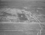
Aerial view of the football stadium. | 1920; 1921; 1922; 1923; 1924; 1925; 1926; 1927; 1928; 1929; 1930; 1931; 1932; 1933; 1934; 1935; 1936; 1937; 1938; 1939 | Image | uum_map |
| 570 |
 |
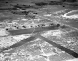
Aerial view of the Salt Lake Airport. | 1910; 1911; 1912; 1913; 1914; 1915; 1916; 1917; 1918; 1919; 1920; 1921; 1922; 1923; 1924; 1925; 1926; 1927; 1928; 1929; 1930; 1931; 1932; 1933; 1934; 1935; 1936; 1937; 1938; 1939 | Image | uum_map |
| 571 |
 |
Aerial view of the Salt Lake Airport. | 1910; 1911; 1912; 1913; 1914; 1915; 1916; 1917; 1918; 1919; 1920; 1921; 1922; 1923; 1924; 1925; 1926; 1927; 1928; 1929; 1930; 1931; 1932; 1933; 1934; 1935; 1936; 1937; 1938; 1939 | Image | uum_map |
| 572 |
 |
Aerial view of the Salt Lake Airport. | 1910; 1911; 1912; 1913; 1914; 1915; 1916; 1917; 1918; 1919; 1920; 1921; 1922; 1923; 1924; 1925; 1926; 1927; 1928; 1929; 1930; 1931; 1932; 1933; 1934; 1935; 1936; 1937; 1938; 1939 | Image | uum_map |
| 573 |
 |
Aerial view of the Salt Lake Airport. | 1910; 1911; 1912; 1913; 1914; 1915; 1916; 1917; 1918; 1919; 1920; 1921; 1922; 1923; 1924; 1925; 1926; 1927; 1928; 1929; 1930; 1931; 1932; 1933; 1934; 1935; 1936; 1937; 1938; 1939 | Image | uum_map |
| 574 |
 |
Aerial view of the Salt Lake Airport. | 1910; 1911; 1912; 1913; 1914; 1915; 1916; 1917; 1918; 1919; 1920; 1921; 1922; 1923; 1924; 1925; 1926; 1927; 1928; 1929; 1930; 1931; 1932; 1933; 1934; 1935; 1936; 1937; 1938; 1939 | Image | uum_map |
| 575 |
 |
Aerial view of the Salt Lake Airport. | 1910; 1911; 1912; 1913; 1914; 1915; 1916; 1917; 1918; 1919; 1920; 1921; 1922; 1923; 1924; 1925; 1926; 1927; 1928; 1929; 1930; 1931; 1932; 1933; 1934; 1935; 1936; 1937; 1938; 1939 | Image | uum_map |