| | Title | Collection Number And Name | Photo Number |
|---|
| 1 | 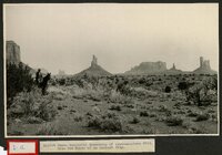 | Amidst these wonderful monuments of south-eastern Utah, like the ruins of an ancient city | P0004 Wasatch Mountain Club Photograph Collection | P0004n08_01_010 |
| 2 |  | Grand Canyon | P0004 Wasatch Mountain Club Photograph Collection | P0004n09_01_069 |
| 3 | 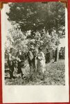 | Scenes in the beautiful Kaibab Forest [01] | P0004 Wasatch Mountain Club Photograph Collection | P0004n09_01_075 |
| 4 |  | Scenes in the beautiful Kaibab Forest [02] | P0004 Wasatch Mountain Club Photograph Collection | P0004n09_01_076 |
| 5 |  | In the Kaibab Forest | P0004 Wasatch Mountain Club Photograph Collection | P0004n12_01_134 |
| 6 | 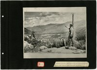 | Wasatch Mountain Club photo album, Book 7 | P0004 Wasatch Mountain Club Photograph Collection | P0004n14_book |
| 7 | 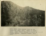 | West Kaibab fault at Oak Creek Mar, Ryan, AZ. Notch is fault plan. Basal Hermit brought to level of Middle Kaibab. Coconino County, AZ. 1922 | P0013 Herbert E. Gregory Photograph Collection | P0013n08_143_1589 |
| 8 | 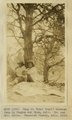 | Camp on 'Lost Trail' between Jump Up Canyon and Ryan, AZ. Dr. and Mrs. Noble. Coconino County, AZ. 1922 | P0013 Herbert E. Gregory Photograph Collection | P0013n08_143_1590 |
| 9 |  | Kanab Canyon, above mouth of Jump Up Canyon. Surface and water pocket of 'Esplanade' developed at top of Supai. Coconino County, AZ. 1922 | P0013 Herbert E. Gregory Photograph Collection | P0013n08_143_1591 |
| 10 | 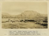 | Kanab Canyon, above Jump Up Canyon. Surface of Esplanade formed at top of Supai. Coconino County, AZ. 1922 | P0013 Herbert E. Gregory Photograph Collection | P0013n08_144_1592 |
| 11 |  | Kanab Valley, above the mouth of Jump Up Canyon. Section is Supai, erosional unconformity, Hermit Coconino, Kaibab sandstone, Kaibab limestone. Coconino County, AZ. 1922 | P0013 Herbert E. Gregory Photograph Collection | P0013n08_144_1593 |
| 12 |  | Kanab Creek, view looking toward mouth of Hack's Canyon. Stream intrenched in Supai, the top of which forms Esplanade. Strata are Supai, Hermit Coconino (forming slope), Kaibab sandstone and limestone, Kaibab cherty limestone. Coconino County, AZ. 1922 | P0013 Herbert E. Gregory Photograph Collection | P0013n08_145_1594 |
| 13 |  | Kanab Canyon, 2 miles south, tributary Little Springs Canyon. Section includes Hermit Coconino, Kaibab, Coconino County, AZ. 1922 | P0013 Herbert E. Gregory Photograph Collection | P0013n08_145_1595 |
| 14 |  | Kanab Canyon. View near mouth of tributary Little Springs Canyon. Coconino County, AZ. 1922 | P0013 Herbert E. Gregory Photograph Collection | P0013n08_146_1597 |
| 15 |  | Camp at Reservoir 2 miles south of Fredonia. Dr. and Mrs. Noble and three packers. Coconino County, AZ. 1922 | P0013 Herbert E. Gregory Photograph Collection | P0013n08_147_1600 |
| 16 |  | House of Henry Fraehier. Littlefield, Mojave County, AZ. 1922 | P0013 Herbert E. Gregory Photograph Collection | P0013n08_151_1609 |
| 17 |  | Froehmer House at Littlefield. 1922 | P0013 Herbert E. Gregory Photograph Collection | P0013n08_159_1628 |
| 18 |  | Looking up canyon of lower Kanab Creek from a point 3 miles below the mouth of Snake Gulch. AZ. 1922 | P0013 Herbert E. Gregory Photograph Collection | P0013n08_161_1637 |
| 19 | 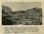 | Supai Sandstone, lower Kanab Creek. Mouth of Karks Canyon at left. Arrow points to horizon of bed of limestone conglomerate. AZ | P0013 Herbert E. Gregory Photograph Collection | P0013n08_161_1638 |
| 20 | 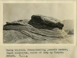 | Cross-bedding, summit member, Supai sandstone, mouth of Jump Up Canyon, AZ. 1922 | P0013 Herbert E. Gregory Photograph Collection | P0013n08_161_1639 |
| 21 | 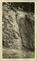 | [Faulting in rock layers, probably Kanab Creek Canyon, Arizona, 1922] | P0013 Herbert E. Gregory Photograph Collection | P0013n08_161_1640 |
| 22 | 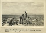 | First camp out of Fredonia, UT. 1922 | P0013 Herbert E. Gregory Photograph Collection | P0013n08_163_1632 |
| 23 | 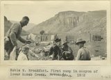 | Breakfast. First camp in canyon of lower Kanab Creek, AZ. 1922 | P0013 Herbert E. Gregory Photograph Collection | P0013n08_164_1633 |
| 24 |  | Panoramic with view attached | P0013 Herbert E. Gregory Photograph Collection | P0013n08_170_1666 |
| 25 | 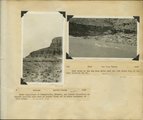 | Herbert E. Gregory Book 10: San Juan, Zion, Capitol Reef, 1915-1938 | P0013 Herbert E. Gregory Photograph Collection | P0013n10 |