|
|
Title | Collection Number And Name | Photo Number |
| 251 |
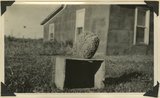 |
Septarium from the Dakota sandstone--common in this area. Abajo Mountains. Utah, San Juan, 1915. | P0013 Herbert E. Gregory Photograph Collection | P0013n10_038_2153 |
| 252 |
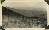
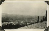 |
Cottonwood Canyon, Beef Basin and North Elks, looking west from West Mountain. Abajo Mountains. Utah, San Juan, 1915. | P0013 Herbert E. Gregory Photograph Collection | P0013n10_038_2154 |
| 253 |
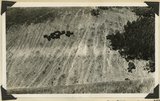 |
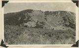
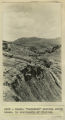
"The Washboard," head of North Canyon, looking west. Erosion caused by sheep grazing. Abajo Mountains. Utah, San Juan, 1915. | P0013 Herbert E. Gregory Photograph Collection | P0013n10_039_2155 |
| 254 |
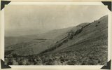 |
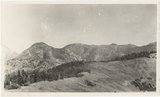
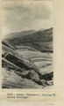
Roberson Pasture and Beef Basin, looking west. Abajo Mountains. Utah, San Juan, 1915. | P0013 Herbert E. Gregory Photograph Collection | P0013n10_040_2156 |
| 255 |
 |
Contact between Mancos shale and igneous rock, head of Harts Draw Wash, Abajo Mountains. Utah, San Juan, 1915. | P0013 Herbert E. Gregory Photograph Collection | P0013n10_040_2157 |
| 256 |
 |
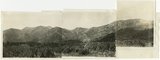
North Elk Ridge in background, divide between Shay and West Mts., in middle ground and Roberson pasture in foreground. Abajo Mountains. Utah, San Juan, 1915. | P0013 Herbert E. Gregory Photograph Collection | P0013n10_041_2158 |
| 257 |
 |
West slope of Horsehead Peak, Abajo Mountains. Utah, San Juan, 1915. | P0013 Herbert E. Gregory Photograph Collection | P0013n10_041_2159 |
| 258 |
 |
Panorama of head of Johnson Creek, from West Mountain. Abajo Mountains. 1915 | P0013 Herbert E. Gregory Photograph Collection | P0013n10_042_2160 |
| 259 |
 |
Panorama, looking west from Camp Jackson. West Peak in left center. Abajo Mountains. Utah, San Juan, 1915. | P0013 Herbert E. Gregory Photograph Collection | P0013n10_042_2161 |
| 260 |
 |
Herbert E. Gregory Book 13: Photographs taken on Yale Peruvian Expeditions, 1911-1915 | P0013 Herbert E. Gregory Photograph Collection | P0013n13 |
| 261 |
 |
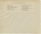
Guano Island, Peruvian coast. | P0013 Herbert E. Gregory Photograph Collection | P0013n13_001_9-2945 |
| 262 |
 |
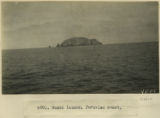
Payta, Panprama continues to left, showing at the extreme left the station of the Piura railroad | P0013 Herbert E. Gregory Photograph Collection | P0013n13_001_9-2947 |
| 263 |
 |
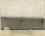
Pacasmayo. The cliffs and surf with distant view of port and pier from top of cliffs to the northwest | P0013 Herbert E. Gregory Photograph Collection | P0013n13_003_9-2950 |
| 264 |
 |
Payta. The beach. A typical dugout canoe, and characteristic houses of the better class. Looking east | P0013 Herbert E. Gregory Photograph Collection | P0013n13_003_9-2952 |
| 265 |
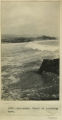 |
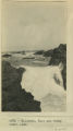
Mollendo. Crest of incoming wave | P0013 Herbert E. Gregory Photograph Collection | P0013n13_004_9-2953 |
| 266 |
 |
Crucero Alto, railroad pass | P0013 Herbert E. Gregory Photograph Collection | P0013n13_004_9-2954 |
| 267 |
 |
Mollendo. Surf and rocky coast line | P0013 Herbert E. Gregory Photograph Collection | P0013n13_005_9-2955 |
| 268 |
 |
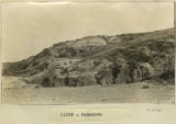
La Raya. Abandoned moraine | P0013 Herbert E. Gregory Photograph Collection | P0013n13_005_9-2956 |
| 269 |
 |
Cuzco. Weathering in igneous mass underlying Sacsahuanan, Cuzco | P0013 Herbert E. Gregory Photograph Collection | P0013n13_006_9-2957 |
| 270 |
 |
Cuzco. "Rodadero", looking NW across flutings | P0013 Herbert E. Gregory Photograph Collection | P0013n13_006_9-2958 |
| 271 |
 |
Cuzco. "Rodadero" showing sharp break in continuity of fluting | P0013 Herbert E. Gregory Photograph Collection | P0013n13_007_9-2959 |
| 272 |
 |
Cuzco. "Rodadero" showing change in direction of fluting. N 30 degrees E and E 60 degrees W in close proximity | P0013 Herbert E. Gregory Photograph Collection | P0013n13_007_9-2960 |
| 273 |
 |
Rodadero | P0013 Herbert E. Gregory Photograph Collection | P0013n13_008_9-2961 |
| 274 |
 |
Cuzco Valley | P0013 Herbert E. Gregory Photograph Collection | P0013n13_008_9-2962 |
| 275 |
 |
Rodadero | P0013 Herbert E. Gregory Photograph Collection | P0013n13_009_9-2963 |