|
|
Title | Collection Number And Name | Photo Number |
| 201 |
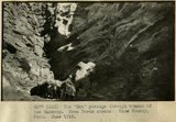 |
The 'Gut' passage through branch of the Wahweap. Mesa Verde strata. Kane County, UT. June 1918 | P0013 Herbert E. Gregory Photograph Collection | P0013n08_107_1515 |
| 202 |
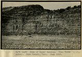 |
Bank of Upper Wahweap. Mesa Verde strata. Kane County, UT. June 1918 | P0013 Herbert E. Gregory Photograph Collection | P0013n08_107_1516 |
| 203 |
 |
Camp in Kanab Canyon 2 miles below mouth of Snake Gulch | P0013 Herbert E. Gregory Photograph Collection | P0013n08_164_1635 |
| 204 |
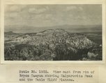 |
View east from rim of Bryce Canyon showing Kaiparowitz Peak and the Table Cliff Plateau | P0013 Herbert E. Gregory Photograph Collection | P0013n08_167_1654 |
| 205 |
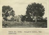 |
Mangum's hotel, Cannonville | P0013 Herbert E. Gregory Photograph Collection | P0013n08_167_1655 |
| 206 |
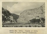 |
Canyon of Paria Creek in white Navajo sandstone | P0013 Herbert E. Gregory Photograph Collection | P0013n08_167_1656 |
| 207 |
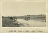 |
Pond on Kaiparowitz Plateau | P0013 Herbert E. Gregory Photograph Collection | P0013n08_173_1678 |
| 208 |
 |
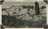
Extreme head of Gold Queen Gulch. Abajo Peak on the right. Slope composed of blue porphyry talus. Abajo Mountains. Utah, San Juan, 1915. | P0013 Herbert E. Gregory Photograph Collection | P0013n10_024_2126 |
| 209 |
 |
Shay Mountain, looking northwest across Indian Creek from the Abajo Mountain. Utah, San Juan, 1915. | P0013 Herbert E. Gregory Photograph Collection | P0013n10_024_2126ABC |
| 210 |
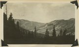 |
Head of Indian Creek, looking west. Mt. Linnaeus (West mountain) in left distance. Abajo Mountains. Utah, San Juan, 1915. | P0013 Herbert E. Gregory Photograph Collection | P0013n10_025_2127 |
| 211 |
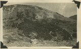 |
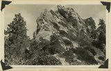
South side of Horsehead Peak, showing slide rock masses of porphyry, Abajo Mountains. Utah, San Juan, 1915. | P0013 Herbert E. Gregory Photograph Collection | P0013n10_025_2128 |
| 212 |
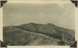 |
Jackson Divide and Mount Linnaeus (West Peak) looking west, Abajo Mountains. Utah, San Juan, 1915. | P0013 Herbert E. Gregory Photograph Collection | P0013n10_026_2129 |
| 213 |
 |
Divide between West and Shay Mountains. West side of Indian Creek, Abajo Mountains. Utah, San Juan, 1915. | P0013 Herbert E. Gregory Photograph Collection | P0013n10_026_2130 |
| 214 |
 |
Shallow lake between Johnson and Recapture Creeks. Looking west. Abajo Mountains. Lake on uneven surface of igneous sheet. Utah, San Juan, 1915. | P0013 Herbert E. Gregory Photograph Collection | P0013n10_027_2131 |
| 215 |
 |
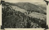
Head of North Canyon, showing sharp differentiation of vegetation. Abajo Mountains. Utah, San Juan, 1915. | P0013 Herbert E. Gregory Photograph Collection | P0013n10_027_2132 |
| 216 |
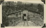 |
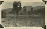
Tunnel house, Dream Mine, Johnson Creek. S. J. Houser, owner. Abajo Mountains. Utah, San Juan, 1915. | P0013 Herbert E. Gregory Photograph Collection | P0013n10_028_2133 |
| 217 |
 |
Dakota cliff, east wall of Bulldog Canyon. Abajo Mountains. Utah, San Juan, 1915. | P0013 Herbert E. Gregory Photograph Collection | P0013n10_028_2134 |
| 218 |
 |
Contact between Mancos shale and igneous rock, at head of Harts Draw, Abajo Mountain. Utah, San Juan, 1915. | P0013 Herbert E. Gregory Photograph Collection | P0013n10_029_2135 |
| 219 |
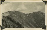
 |
North slope of Jackson Divide. Compare with no. 614. Abajo Mountains. Utah, San Juan, 1915. | P0013 Herbert E. Gregory Photograph Collection | P0013n10_029_2136 |
| 220 |
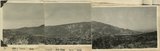
 |
South slope of Jackson Divide. (All south slopes are barren or grassed, all north ones forested.) Abajo Mountains. No. 614, Utah, San Juan, 1915. | P0013 Herbert E. Gregory Photograph Collection | P0013n10_030_2137 |
| 221 |
 |
Upper La Plata sandstone (light-colored), Johnson Creek, Abajo Mountains. Utah, San Juan, 1915. | P0013 Herbert E. Gregory Photograph Collection | P0013n10_030_2138 |
| 222 |
 |
Upturned Dakota sandstone, Johnson Creek, Abajo Mountains. Utah, San Juan, 1915. | P0013 Herbert E. Gregory Photograph Collection | P0013n10_031_2139 |
| 223 |
 |
Dakota sandstone (detail), Johnson Creek near stamp mill. Abajo Mountains, Utah, San Juan, 1915. | P0013 Herbert E. Gregory Photograph Collection | P0013n10_031_2140 |
| 224 |
 |
Head of Johnson Creek, Abajo Mountains. Utah, San Juan, 1915. | P0013 Herbert E. Gregory Photograph Collection | P0013n10_032_2141 |
| 225 |
 |
Head of Johnson Creek, slope facing southward. Abajo Mountains. Utah, San Juan, 1915. | P0013 Herbert E. Gregory Photograph Collection | P0013n10_032_2142 |