TO
Filters: Date: "1913"
| Title | Date | Type | Setname | ||
|---|---|---|---|---|---|
| 51 |
 |
Utah Valley | 1910; 1906; 1907; 1908; 1909; 1911; 1912; 1913; 1914 | Image | dha_ce |
| 52 |
 |
Beautiful view of a farm nestled in a valley | 1890; 1891; 1892; 1893; 1894; 1895; 1896; 1897; 1898; 1899; 1900; 1901; 1902; 1903; 1904; 1905; 1906; 1907; 1908; 1909; 1910; 1911; 1912; 1913; 1914; 1915; 1916; 1917; 1918; 1919 | Image | uum_map |
| 53 |
 |
Diary of Angus M. Woodbury from July 1, 1913 to October 13, 1913 | 1913 | uum_amwp | |
| 54 |
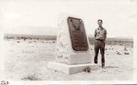 |
Johnsons Army Monument - Cedar Valley, Ut. - Alvin | 1910; 1911; 1912; 1913; 1914; 1915; 1916; 1917; 1918; 1919; 1920; 1921; 1922; 1923; 1924; 1925; 1926; 1927; 1928; 1929; 1930; 1931; 1932; 1933; 1934; 1935 | Image/StillImage | uum_map |
| 55 |
 |
Mountains and Field | 1910; 1906; 1907; 1908; 1909; 1911; 1912; 1913; 1914 | Image | dha_scp |
| 56 |
 |
Valley near Big Cottonwood Canyon | 1900; 1901; 1902; 1903; 1904; 1905; 1906; 1907; 1908; 1909; 1910; 1911; 1912; 1913; 1914; 1915; 1916; 1917; 1918; 1919; 1920; 1921; 1922; 1923; 1924; 1925 | Image/StillImage | dha_gmo |
| 57 |
 |
[view of river valley from cave] | 1910; 1911; 1912; 1913; 1914; 1915; 1916; 1917; 1918; 1919; 1920; 1921; 1922; 1923; 1924; 1925; 1926; 1927; 1928; 1929; 1930; 1931; 1932; 1933; 1934; 1935; 1936; 1937; 1938; 1939; 1940 | Image | uum_map |
| 58 |
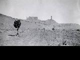 |
Fisher Towers (?) near Castle Valley, Utah | 1910; 1911; 1912; 1913; 1914; 1915; 1916; 1917; 1918; 1919; 1920; 1921; 1922; 1923; 1924; 1925; 1926; 1927; 1928; 1929; 1930; 1931; 1932; 1933; 1934; 1935; 1936; 1937; 1938; 1939; 1940; 1941; 1942; 1943; 1944; 1945; 1946; 1947; 1948; 1949; 1950; 1951; 195 | uum_map_rr | |
| 59 |
 |
Gunnison Butte, looking west | 1910; 1911; 1912; 1913; 1914; 1915; 1916; 1917; 1918; 1919; 1920; 1921; 1922; 1923; 1924; 1925; 1926; 1927; 1928; 1929; 1930; 1931; 1932; 1933; 1934; 1935; 1936; 1937; 1938; 1939; 1940; 1941; 1942; 1943; 1944; 1945 | Image/StillImage | dha_sim |
| 60 |
 |
Uintah School 1906-1940 | 1906; 1907; 1908; 1909; 1910; 1911; 1912; 1913; 1914; 1915; 1916; 1917; 1918; 1919; 1920; 1921; 1922; 1923; 1924; 1925; 1926; 1927; 1928; 1929; 1930; 1931; 1932; 1933; 1934; 1935; 1936; 1937; 1938; 1939; 1940 | Image/StillImage | ucl_maps |
| 61 |
 |
Utah Lake Area - Utah Valley | 1910; 1906; 1907; 1908; 1909; 1911; 1912; 1913; 1914 | Image | dha_ce |
| 62 |
 |
Vernal Dino Dig/ Petroglyphs - [looking out over valley] | 1910; 1911; 1912; 1913; 1914; 1915; 1916; 1917; 1918; 1919; 1920; 1921; 1922; 1923; 1924; 1925; 1926; 1927; 1928; 1929; 1930; 1931; 1932; 1933; 1934; 1935; 1936; 1937; 1938; 1939; 1940 | Image | uum_map |
| 63 |
 |
Cuzco Valley. Detail. | 1912; 1913; 1914; 1915 | Image | uum_map |
| 64 |
 |
Cuzco Valley. Abandoned moraine and cirque on Seneca, facing Chincheros road. | 1912; 1913; 1914; 1915 | Image | uum_map |
| 65 |
 |
Cuzco Valley. Abandoned moraine. Looking down Junapincha. Elev. 15,000 ft. | 1912; 1913; 1914; 1915 | Image | uum_map |
| 66 |
 |
Cuzco Valley. Divided spurs. Carao Valley | 1912; 1913; 1914; 1915 | Image | uum_map |
| 67 |
 |
Cuzco Valley. Erosion feature. Pink sandstone. 3 miles north of Angostura | 1912; 1913; 1914; 1915 | Image | uum_map |
| 68 |
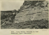 |
Cuzco Valley. Faulting in Pink Sandstone. Upper Junajaneha | 1912; 1913; 1914; 1915 | Image | uum_map |
| 69 |
 |
Cuzco Valley. Looking down Huatanay, from above Anta Branch, 1 mile NW of Cuzco. | 1912; 1913; 1914; 1915 | Image | uum_map |
| 70 |
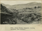 |
Cuzco Valley. Ongapata. Looking upstream. Note terraces | 1912; 1913; 1914; 1915 | Image | uum_map |
| 71 |
 |
Cuzco Valley. Same as 2976. Nearer view, 200 ft. upstream | 1912; 1913; 1914; 1915 | Image | uum_map |
| 72 |
 |
Orpheum Theatre Stage Crew | 1910; 1906; 1907; 1908; 1909; 1911; 1912; 1913; 1914 | Image | dha_scp |
| 73 |
 |
Wind beveling of cross-bedded sandstone, Red Lake Valley | 1913 | Image | uum_map |
| 74 |
 |
Cuzco Valley Choquo branch. Looking S or SE across Huancaro from west side. (compare 2987, 2988, and 2989) | 1912; 1913; 1914; 1915 | Image | uum_map |
| 75 |
 |
Cuzco Valley, Terrace. Ongapata. Looking upstream from 1/2 mile above mouth. Camera pointing south | 1912; 1913; 1914; 1915 | Image | uum_map |
