|
|
Title | Collection Number And Name | Photo Number |
| 276 |
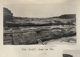 |
Same as 735 (Grand Falls, Photo G417) | P0013 Herbert E. Gregory Photograph Collection | P0013n06_078b_0984 |
| 277 |
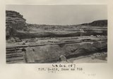 |
Same as 735 (Grand Falls, Photo G418) | P0013 Herbert E. Gregory Photograph Collection | P0013n06_078b_0985 |
| 278 |
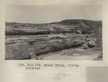 |
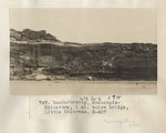
Grand Falls, Little Colorado (Photo N-M175) | P0013 Herbert E. Gregory Photograph Collection | P0013n06_079_0986 |
| 279 |
 |
Grand Falls, Little Colorado (Photo N-M175) | P0013 Herbert E. Gregory Photograph Collection | P0013n06_079_0986 |
| 280 |
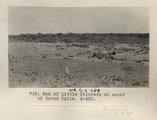 |
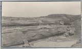
Bed of Little Colorado at crest of Grand Falls (Photo G420) | P0013 Herbert E. Gregory Photograph Collection | P0013n06_079_0987 |
| 281 |
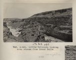 |
Little Colorado looking down stream from Grand Falls (Photo G421) | P0013 Herbert E. Gregory Photograph Collection | P0013n06_080_0988 |
| 282 |
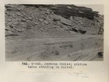 |
Permian shales; picture taken standing on Kaibab (Photo G422) | P0013 Herbert E. Gregory Photograph Collection | P0013n06_080_0989 |
| 283 |
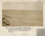 |
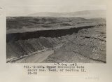
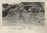
Peneplain; looking southeast from cliffs 5± mi. N 80 deg E, Black Falls (Photo N-M176 and G423) | P0013 Herbert E. Gregory Photograph Collection | P0013n06_081_0990 |
| 284 |
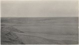 |
Peneplain; looking southeast from cliffs 5± mi. N 80 deg E, Black Falls (Photo N-M176 and G423) | P0013 Herbert E. Gregory Photograph Collection | P0013n06_081_0990 |
| 285 |
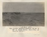 |
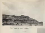
Dolores section, 5± mi. N 80° E, Black Falls (No. 2 etc. of Section IX-13) (Photo G424) | P0013 Herbert E. Gregory Photograph Collection | P0013n06_081_0991 |
| 286 |
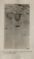 |
Detail, Dolores section, as in No. 742 (Photo G425) | P0013 Herbert E. Gregory Photograph Collection | P0013n06_082_0992 |
| 287 |
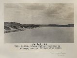 |
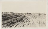
Black Falls, looking up stream; canyon filled with sand (Photo G426) | P0013 Herbert E. Gregory Photograph Collection | P0013n06_082_0993 |
| 288 |
 |
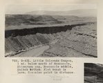
Shinarump 2± mi. below Black Point (Photo N-M177) | P0013 Herbert E. Gregory Photograph Collection | P0013n06_083_0994 |
| 289 |
 |
Unconformity, Moencopie-Shinarump, 1 mi. below bridge, Little Colorado (Photo G427) | P0013 Herbert E. Gregory Photograph Collection | P0013n06_083_0995 |
| 290 |
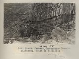 |
Contact, Moencopie-Shinarump, Mouth of Moencopie (Photo G428) | P0013 Herbert E. Gregory Photograph Collection | P0013n06_084_0996 |
| 291 |
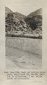 |
Wall of Little Colorado, sectioned IX, 25-28; Kaibab to Shinarump, 1 mi. below mouth of Moencopie (Photo N-M178) | P0013 Herbert E. Gregory Photograph Collection | P0013n06_084_0997 |
| 292 |
 |
Little Colorado canyon, 1 mi. below mouth of Moencopie. Shinarump cap, Moencopie middle, Kaibab bottom. Flat bench is lava. Coconino point in distance (Photo G430) | P0013 Herbert E. Gregory Photograph Collection | P0013n06_085_0998 |
| 293 |
 |
Upper Moencopie beds about Nos. 7-26 of Section IX, 25-28 (Photo G430) | P0013 Herbert E. Gregory Photograph Collection | P0013n06_085_0999 |
| 294 |
 |
Little Colorado Canyon, 1 mi. below mouth of Moencopie, Shinarump cap, Moencopie middle, Kaibab bottom. Flat bench is lava. Coconino point in distance (Photo G431) | P0013 Herbert E. Gregory Photograph Collection | P0013n06_086_1000 |
| 295 |
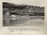 |
Shinarump-Moencopie contact 1 mi. below bridge, Little Colorado (Photo N-M179) | P0013 Herbert E. Gregory Photograph Collection | P0013n06_086_1001 |
| 296 |
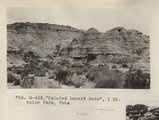 |
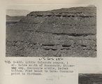
"Painted Desert Bads", 1 mi. below Farm, Tuba (Photo G432) | P0013 Herbert E. Gregory Photograph Collection | P0013n06_087_1002 |
| 297 |
 |
Same as 754 (Painted Desert, Tuba, Photo G433) | P0013 Herbert E. Gregory Photograph Collection | P0013n06_087_1003 |
| 298 |
 |
Same as 754 (Painted Desert, Tuba, Photo G434) | P0013 Herbert E. Gregory Photograph Collection | P0013n06_088_1004 |
| 299 |
 |
Wind erosion, La Plata, Tuba (Photo G435) | P0013 Herbert E. Gregory Photograph Collection | P0013n06_088_1005 |
| 300 |
 |
Wind erosion, La Plata, Tuba (Photo G435) | P0013 Herbert E. Gregory Photograph Collection | P0013n06_088_1005 |