Over 70,000 photos covering a variety of topics from Marriott Library Special Collections
TO
| Title | Collection Number And Name | Photo Number | ||
|---|---|---|---|---|
| 176 |
 |
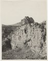
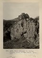
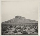
Eroded neck at northwest corner of Moqui Butte area (Photo G233) | P0013 Herbert E. Gregory Photograph Collection | P0013n05_38_0733 |
| 177 |
 |
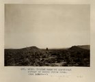
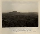
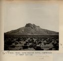
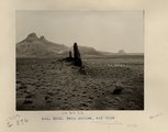
Round Top and Montezuma's Chair. Moqui BUttes. Looking southwest from 5± mi. southwest of Cedar Springs. Heald, photo. 1911 (Photo N-M125) | P0013 Herbert E. Gregory Photograph Collection | P0013n05_39_0734 |
| 178 |
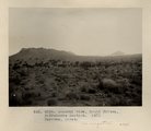 |
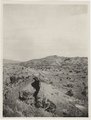
General view, Moqui Buttes, Biddehoche Section. Barrows, photo. 1911 (Photo G234) | P0013 Herbert E. Gregory Photograph Collection | P0013n05_40_0735 |
| 179 |
 |
Dike (diabase?), Stiles Ranche, Moqui Buttes region, AZ. 1911 (Photo G235) | P0013 Herbert E. Gregory Photograph Collection | P0013n05_40_0736 |
| 180 |
 |
Dike (diabase?), Stiles Ranche, Moqui Buttes region, AZ. 1911 (Photo G235) | P0013 Herbert E. Gregory Photograph Collection | P0013n05_41_0736 |
| 181 |
 |
Dike (diabase), Stiles Ranche, 30± mi. north of Winslow, AZ. 1911 (Photo G236) | P0013 Herbert E. Gregory Photograph Collection | P0013n05_41_0737 |
| 182 |
 |
Dike (diabase), Stiles Ranche, 30± mi. north of Winslow, AZ. 1911 (Photo G236) | P0013 Herbert E. Gregory Photograph Collection | P0013n05_42_0737 |
| 183 |
 |
Dike (diabase), Stiles Ranche 30± mi. north of Winslow, AZ. 1911 (Photo G237) | P0013 Herbert E. Gregory Photograph Collection | P0013n05_43_0738 |
| 184 |
 |
Butte, 3± mi. west of Stiles Ranche (Photo G238) | P0013 Herbert E. Gregory Photograph Collection | P0013n05_43_0739 |
| 185 |
 |
Butte, 3± mi. west of Stiles Ranche (Photo G238) | P0013 Herbert E. Gregory Photograph Collection | P0013n05_44_0739 |
| 186 |
 |
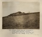
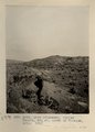
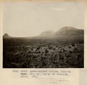
General view, Moqui Buttes region, Cedar Springs area. Barrows, photo. 1911 (Photo G239) | P0013 Herbert E. Gregory Photograph Collection | P0013n05_45_0740 |
| 187 |
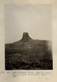 |
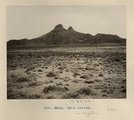
Chimney Butte, volcanic neck, 25± mi. north of Winslow, AZ. 1911 (Photo G240) | P0013 Herbert E. Gregory Photograph Collection | P0013n05_46_0741 |
| 188 |
 |
Same as Photo G240 (Chimney Butte, Photo G241) | P0013 Herbert E. Gregory Photograph Collection | P0013n05_47_0742 |
| 189 |
 |
Same as Photo G240 (Chimney Butte, Photo G241) | P0013 Herbert E. Gregory Photograph Collection | P0013n05_47_0742 |
| 190 |
 |
Basalt, Cedar Springs, AZ. 35± mi. north of Winslow. 1911 (Photo G242) | P0013 Herbert E. Gregory Photograph Collection | P0013n05_48_0743 |
| 191 |
 |
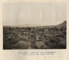
Lava-capped buttes, Coyote wash, 30± mi. north of Winslow, AZ. 1911 (Photo G243) | P0013 Herbert E. Gregory Photograph Collection | P0013n05_49_0744 |
| 192 |
 |
Lava-capped butte, near Stiles ranche. Barrows, photo (Photo G244) | P0013 Herbert E. Gregory Photograph Collection | P0013n05_49_0745 |
| 193 |
 |
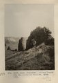
Round Top and Montezuma's Chair from near Cedar Springs (Photo G245) | P0013 Herbert E. Gregory Photograph Collection | P0013n05_50_0746 |
| 194 |
 |
Lava-capped butte, northwest of Cedar Springs (Photo G246) | P0013 Herbert E. Gregory Photograph Collection | P0013n05_50_0749 |
| 195 |
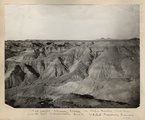 |
Bad lands, Chinle strata in Hopi Buttes region, north east of Holbrook, Ariz. USGS, probably Darton | P0013 Herbert E. Gregory Photograph Collection | P0013n05_50verso_0748 |
| 196 |
 |
Lava-capped butte, northwest of Cedar Springs (Photo G246) | P0013 Herbert E. Gregory Photograph Collection | P0013n05_51_0749 |
| 197 |
 |
Twin Buttes, volcanic neck, 6± mi. south of Biddehoche, Ariz. 1911 (Photo G247) | P0013 Herbert E. Gregory Photograph Collection | P0013n05_51_0750 |
| 198 |
 |
Twin Buttes (Photo G248) | P0013 Herbert E. Gregory Photograph Collection | P0013n05_52_0751 |
| 199 |
 |
Twin Buttes, and dike (Photo G249) | P0013 Herbert E. Gregory Photograph Collection | P0013n05_53_0752 |
| 200 |
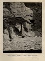 |
Detail, ash, Twin Buttes (Photo G250) | P0013 Herbert E. Gregory Photograph Collection | P0013n05_54_0753 |