|
|
Title | Collection Number And Name | Photo Number |
| 151 |
 |
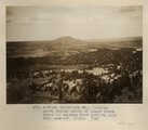
Todilto park, looking south. Defiance Mesas in skyline. Heald, photo. 1911 (Photo N-M117) | P0013 Herbert E. Gregory Photograph Collection | P0013n05_25_0710 |
| 152 |
 |
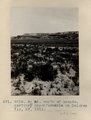
Baigaiche Mt., looking south across mouth of Black creek where it emerges from Todilto Park. Mrs. Gregory, photo. 1911 (Photo N-M118) | P0013 Herbert E. Gregory Photograph Collection | P0013n05_26_0711 |
| 153 |
 |
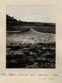
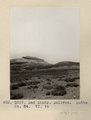
3± mi. north of Ganado. Tertiary unconformable on Dolores. VII, 19. 1911 (Photo G218) | P0013 Herbert E. Gregory Photograph Collection | P0013n05_27_0712 |
| 154 |
 |
Farmer Ant, Ganado. 1911 (Photo G219) | P0013 Herbert E. Gregory Photograph Collection | P0013n05_27_0713 |
| 155 |
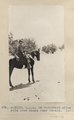 |
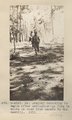
E.H.G. on horseback after ride over mesas near Ganado. 1911 (Photo N-M119) | P0013 Herbert E. Gregory Photograph Collection | P0013n05_28_0714 |
| 156 |
 |
Dr. Gregory returning to wagon after extinguishing fire in woods on road from Ganado to the sawmill. 1911 (Photo N-M120) | P0013 Herbert E. Gregory Photograph Collection | P0013n05_28_0715 |
| 157 |
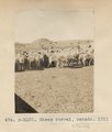 |
Sheep corral, Ganado. 1911 (Photo N-M122) | P0013 Herbert E. Gregory Photograph Collection | P0013n05_29_0716 |
| 158 |
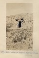 |
Hogan at Sunrise Springs store (Photo G220) | P0013 Herbert E. Gregory Photograph Collection | P0013n05_29_0717 |
| 159 |
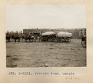 |
Freight team, Ganado (Photo N-M121) | P0013 Herbert E. Gregory Photograph Collection | P0013n05_29_0718 |
| 160 |
 |
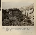
Cliffs west of Cornfields, south of Ganado; on west side of Pueblo Colorado Wash. Heald, 1911 (Photo N-M123) | P0013 Herbert E. Gregory Photograph Collection | P0013n05_30_0719 |
| 161 |
 |
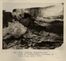
Dakota unconformity on McElmo. Tse-bito wash. VII, 4. 1911 (Photo G221) | P0013 Herbert E. Gregory Photograph Collection | P0013n05_30_0720 |
| 162 |
 |
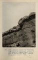
Tertiary limestone near mouth of Tsebito wash, northeast of White Cone, AZ. 1911 (Photo G222) | P0013 Herbert E. Gregory Photograph Collection | P0013n05_31_0721 |
| 163 |
 |
Tertiary limestone unconformably overlaying sandstone (McElmo?) near mouth of Tsebito wash, northeast of White Cone, AZ (Tusayan topographic sheet). 1911 (Photo G223) | P0013 Herbert E. Gregory Photograph Collection | P0013n05_32_0722 |
| 164 |
 |
Jetty-to Springs, Mesa Verde sandstone on Mancos shale. 1911 (Photo G224) | P0013 Herbert E. Gregory Photograph Collection | P0013n05_33_0723 |
| 165 |
 |
Jetty-to Springs, Mesa Verde sandstone on Mancos shale. 1911 (Photo G224) | P0013 Herbert E. Gregory Photograph Collection | P0013n05_33_0723 |
| 166 |
 |
McElmo-Dakota unconformity southwest of Jetty-to. 1911 (Photo N-M124) | P0013 Herbert E. Gregory Photograph Collection | P0013n05_33_0724 |
| 167 |
 |
Jetty-to Springs, Mesa Verde sandstone on Mancos shale. 1910 (Photo G225) | P0013 Herbert E. Gregory Photograph Collection | P0013n05_34_0725 |
| 168 |
 |
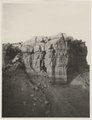
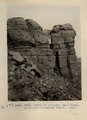
Bad Lands, Dolores. Lower Pueblo Colorado Wash. Section VI, 79-80. 1911 (Photo G226) | P0013 Herbert E. Gregory Photograph Collection | P0013n05_35_0726 |
| 169 |
 |
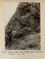
Bad Lands. Dolores. Butte No. 24. VI, 76 (Photo G227) | P0013 Herbert E. Gregory Photograph Collection | P0013n05_35_0727 |
| 170 |
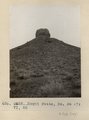 |
Moqui Butte, No. 36, VI, 82 (Photo G228) | P0013 Herbert E. Gregory Photograph Collection | P0013n05_36_0728 |
| 171 |
 |
Moqui Butte No. 23. VI, 75 (Photo G229) | P0013 Herbert E. Gregory Photograph Collection | P0013n05_36_0729 |
| 172 |
 |
Moqui Butte No. 23, VI, 75 (Photo G230) | P0013 Herbert E. Gregory Photograph Collection | P0013n05_37_0730 |
| 173 |
 |
Ash and tuff near Biddehoche. VI, 84 (Photo G231) | P0013 Herbert E. Gregory Photograph Collection | P0013n05_37_0731 |
| 174 |
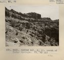 |
Bedded ash, 2± mi. south of Cedar Springs. VI, 73 (2) (Photo G232) | P0013 Herbert E. Gregory Photograph Collection | P0013n05_37_0732 |
| 175 |
 |
Eroded neck at northwest corner of Moqui Butte area (Photo G233) | P0013 Herbert E. Gregory Photograph Collection | P0013n05_38_0733 |