|
|
Title | Collection Number And Name | Photo Number |
| 226 |
 |
Cross bedding, Nazlini canyon, 2± mi. above store. Moencopie. 1911 (Photo G269) | P0013 Herbert E. Gregory Photograph Collection | P0013n05_65_0775 |
| 227 |
 |
Unconformity, Shinarump on Moencopie, Nazlini canyon, 3± mi. below store. VII, 23 (Photo G270) | P0013 Herbert E. Gregory Photograph Collection | P0013n05_65_0776 |
| 228 |
 |
Old store, Nazlini canyon, VII, 23 (Photo N-M126) | P0013 Herbert E. Gregory Photograph Collection | P0013n05_66_0777 |
| 229 |
 |
Bad Lands (Dolores) near Chinlee. VII, 26 (Photo G271) | P0013 Herbert E. Gregory Photograph Collection | P0013n05_66_0778 |
| 230 |
 |
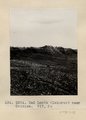
Shinarump Unconformity, Chinlee. VII, 26 (Photo G272) | P0013 Herbert E. Gregory Photograph Collection | P0013n05_67_0779 |
| 231 |
 |
Edna's Needle, LaPlata, west of Chinlee. VII, 29 (Photo G274) | P0013 Herbert E. Gregory Photograph Collection | P0013n05_67_0780 |
| 232 |
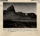 |
General view of LaPlata, west of Chinlee. VII, 29 (Photo G273) | P0013 Herbert E. Gregory Photograph Collection | P0013n05_67_0781 |
| 233 |
 |
Erosion on column, LaPlata, west of Chinlee. VII, 33 (Photo G275) | P0013 Herbert E. Gregory Photograph Collection | P0013n05_68_0782 |
| 234 |
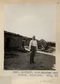 |
G.W. McAdam and store, Chinlee. VII, 26 (Photo N-M127) | P0013 Herbert E. Gregory Photograph Collection | P0013n05_68_0783 |
| 235 |
 |
Dolores shales and marls, 2± mi. above Round Rock store on Carriso Creek at Plue Point (Pish-dot-klish-is-a). VII, 40 (Photo G276) | P0013 Herbert E. Gregory Photograph Collection | P0013n05_68_0784 |
| 236 |
 |
Bed (9), section of Dolores and LaPlata west of Chinlee. VII, 28 (Photo G277) | P0013 Herbert E. Gregory Photograph Collection | P0013n05_69_0785 |
| 237 |
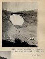 |
Window, (LaPlata) west of Chinlee. VII, 29 (Photo G279) | P0013 Herbert E. Gregory Photograph Collection | P0013n05_69_0786 |
| 238 |
 |
Bed (4), section of Dolores and LaPlata, west of Chinlee. VII, 28 (Photo G278) | P0013 Herbert E. Gregory Photograph Collection | P0013n05_69_0787 |
| 239 |
 |
Window in LaPlata, west of Chinlee. Bed (1), Dolores-LaPlata section, VII, 29 (Photo G280) | P0013 Herbert E. Gregory Photograph Collection | P0013n05_70_0788 |
| 240 |
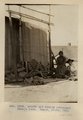 |
Arnold and family (Chinlee) Navajo loom. Heald, photo, 1911 (Photo G282) | P0013 Herbert E. Gregory Photograph Collection | P0013n05_71_0789 |
| 241 |
 |
Petrified wood in forest south of Tsen-a-kahn. VII, 36 (Photo G283) | P0013 Herbert E. Gregory Photograph Collection | P0013n05_72_0790 |
| 242 |
 |
Fossil tree, between Chinlett and Round Rock (Photo G283A) | P0013 Herbert E. Gregory Photograph Collection | P0013n05_72_0791 |
| 243 |
 |
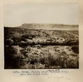
Tse-na-kahn, looking northwest. LaPlata sandstone (Photo G-284) | P0013 Herbert E. Gregory Photograph Collection | P0013n05_73_0792 |
| 244 |
 |
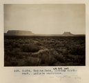
Tse-na-kahn (Round Rock), from southeast. New Mexico. Heald, photo. 1911 (Photo N-M128) | P0013 Herbert E. Gregory Photograph Collection | P0013n05_74_0793 |
| 245 |
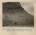 |
Cross-bedded LaPlata sandstone, west of Chinlee. VII, 33 (Photo G285) | P0013 Herbert E. Gregory Photograph Collection | P0013n05_74_0794 |
| 246 |
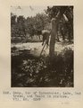 |
Camp, top of Kukachukai. Lake, Oak trees, and Heald in picture. VII, 50 (Photo G287) | P0013 Herbert E. Gregory Photograph Collection | P0013n05_75_0795 |
| 247 |
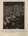 |
Quartzite columns, Lukachukai Mts. VII, 50 (Photo G288) | P0013 Herbert E. Gregory Photograph Collection | P0013n05_76_0796 |
| 248 |
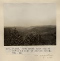 |
View south from top of Butte at head of Spruce Brook. VII, 52 (Photo G-289) | P0013 Herbert E. Gregory Photograph Collection | P0013n05_76_0797 |
| 249 |
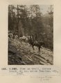 |
View on trail, Spruce Brook, 5+ mi. above Tsa-lee. VII, 1911 (Photo G-290) | P0013 Herbert E. Gregory Photograph Collection | P0013n05_77_0798 |
| 250 |
 |
Dike, Whiskey Creek. 1911 (Photo G291) | P0013 Herbert E. Gregory Photograph Collection | P0013n05_77_0799 |