Home
Browse
Ask Us
Chat
Harmful Language Statement
Log in
Advanced Search
Year
1880
1881
1882
1883
1884
1885
1886
1887
1888
1889
1890
1891
1892
1893
1894
1895
1896
1897
1898
1899
1900
1901
1902
1903
1904
1905
1906
1907
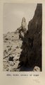
1908
1909
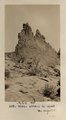
1910
1911
1912
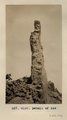
1913
1914
1915
1916
1917
1918
1919
1920
1921
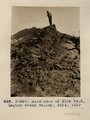
1922
1923
1924
1925
1926
1927
1928
1929
1930
1931
1932
1933
1934
1935
1936
1937
1938
1939
1940
1941
1942
1943
1944
TO
1880
1881
1882
1883
1884
1885
1886
1887
1888
1889
1890
1891
1892
1893
1894
1895
1896
1897
1898
1899
1900
1901
1902
1903
1904
1905
1906
1907
1908
1909
1910
1911
1912
1913
1914
1915
1916
1917
1918
1919
1920
1921
1922
1923
1924
1925
1926
1927
1928
1929
1930
1931
1932
1933
1934
1935
1936
1937
1938
1939
1940
1941
1942
1943
1944
Type
Image
76
Image/StillImage
39
Text
6
Format
image/jpeg
84
application/pdf
14
Collection
Classified Photographs
1
Mormon Settlement in Arizona
6
Photo Archives
91
UAIDA Main Collection
23
Filters:
Date:
"1910"
Spatial Coverage:
"Arizona"
26
-
50
of
121
<
1
2
3
4
5
>
Gallery view
Number of results to display per page
10
25
50
100
200
Sort by Relevance
Sort by Title A-Z
Sort by Title Z-A
Sort by Date Ascending
Sort by Date Descending
Sort by Last Modified Ascending
Sort by Last Modified Descending
Title
Date
Type
Setname
26
Camp in cave by spring, 8+ mi. southeast of Agathla Needle, 1910 (Photo N-M104)
1910
Image
uum_map
27
Canyon de Chelly near junction with Canyon del Muerto, 1910 (Edna H. Gregory photo, N-M101)
1910
Image
uum_map
28
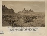
Cha-ez Kla. (No. 4). Volcanic neck or dike, 2+ mi, south of Agathla Needle, Ariz., 1910 (Photo G147)
1910
Image
uum_map
29
Cliff dwelling in Canyon de Chelly (or near mouth of del Muerto), 1910 (photo by Edna H. Gregory)
1910
Image
uum_map
30
Cliff, LaPlata on Dolores at mouth of Sagy at Sosi canyon, Ariz., 1910 (Photo G166)
1910
Image
uum_map
31
Cliff, LaPlata on Dolores at mouth of Sagy at Sosi canyon, AZ. 1910 (Photo G166)
1910
Image
uum_map
32
Cliff-vein in Canyon de Chelly, 1910.
1910
Image
uum_map
33
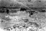
Cornhusking Navajos
1890; 1910
Image/StillImage
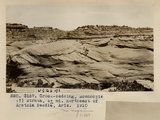
uaida_main
34
Cross-bedding, Moencopie (?) strata, 6+ mi. northeast of Agathla Needle, Ariz., 1910 (Photo G157)
1910
Image
uum_map
35
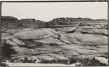
Cross-bedding, Moencopie (?) strata, 6± mi. northeast of Agathla Needle, Ariz., 1910 (Photo G157)
1910
Image
uum_map
36
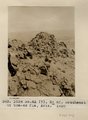
Detail of dike 6 mi. SE of Agathla Needle, Laguna Creek valley, 1910 (Photo G149)
1910
Image
uum_map
37
Detail of dike 6 mi. SE of Agathla Needle, Laguna Creek valley, 1910 (Photo G150)
1910
Image
uum_map
38
Detail of dike 6 mi. SE of Agathla Needle, Laguna Creek valley, 1910 (Photo G151)
1910
Image
uum_map
39
Diaries of John Bushman, 1871-1923, part 2: 1890-1923
1890; 1891; 1892; 1893; 1894; 1895; 1896; 1897; 1898; 1899; 1900; 1901; 1902; 1903; 1904; 1905; 1906; 1907; 1908; 1909; 1910; 1911; 1912; 1913; 1914; 1915; 1916; 1917; 1918; 1919; 1920; 1921; 1922; 1923
Text
uum_msa
40
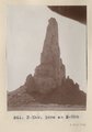
Dike east of Dike no. 2, Laguna Creek valley, Ariz., 1910 (Photo N-M87)
1910
Image
uum_map
41
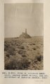
Dike no. 3, 6+ mi. southeast of Agathla Needle, Laguna Creek valley, view from southeast, Ariz., 1910 (Photo G148)
1910
Image
uum_map
42
Dike no. 4A 2+ mil. southeast of Cha-ez Kla, Ariz., 1910.
1910
Image
uum_map
43
Dike or volcanic neck no. 2, Laguna Creek valley, 10+ mi. southeast of Agathla Needle, 1910 (Photo by C.C. Colville)
1910
Image
uum_map
44
Dike or volcanic neck no. 2, Laguna Creek valley, 10+ mi. southeast of Agathla Needle, 1910 (Photo NM88)
1910
Image
uum_map
45
Dike or volcanic neck no. 2, Laguna Creek valley, 10+ mi. southeast of Agathla Needle, 1910 (Photo NM89)
1910
Image
uum_map
46
Dinosaur tracks (J. Wetherill photo)
1910
Image
uum_map
47
Dinosaur tracks, Navajo Canyon (Photo Hopkins, Salt Lake City)
1910
Image
uum_map
48
Dinosaur tracks, Navajo Canyon, Ariz., 1910 (Photo G185)
1910
Image
uum_map
49
Dinosaur tracks, Navajo Canyon, Ariz., 1910 (Photo G185)
1910
Image
uum_map
50
Dr. Pogue on Greybird, 1910
1910
Image
uum_map
26
-
50
of
121
<
1
2
3
4
5
>